Earthquakes
Sunday, March 06, 2011 at 12:31:57 UTC
Sunday, March 06, 2011 at 09:31:57 AM at epicenter
Time of Earthquake in other Time Zones
Location:
18.115°S, 69.391°W
Depth:
101.3 km (62.9 miles) set by location program
Region:
TARAPACA, CHILE
Distances:
92 km (57 miles) E of Tacna, Peru
108 km (67 miles) ENE of Arica, Tarapaca, Chile
193 km (119 miles) ESE of Moquegua, Peru
1704 km (1058 miles) N of SANTIAGO, Region Metropolitana, Chile

Mount Bulusan volcano spews ash in Sorsogon province, eastern Philippines, Nov 2010.
In its 8 a.m. update, Phivolcs also noted weak steaming activity at the southeast thermal vent.
"Bulusan Volcano's status remains at Alert Level 1. This means that the source of activity is hydrothermal and shallow. Entry to the 4-kilometer radius Permanent Danger Zone (PDZ) is strictly prohibited, since the area is at risk to sudden steam and ash explosions," it said.
Citing the prevailing wind direction, Phivolcs reminded residents in the northwest and southwest sectors of the volcano to take precautions against ash falls.
It also said civil aviation authorities must warn pilots to avoid flying close to the volcano's summit as ejected ash and volcanic fragments from sudden explosions may be hazardous to aircraft.
Friday, March 04, 2011 at 15:46:12 UTC
Saturday, March 05, 2011 at 02:46:12 AM at epicenter
Time of Earthquake in other Time Zones
Location:
49.828°S, 164.042°E
Depth:
20.4 km (12.7 miles)
Region:
AUCKLAND ISLANDS, NEW ZEALAND REGION
Distances:
178 km (110 miles) WNW of Auckland Island, New Zealand
498 km (309 miles) SW of Invercargill, New Zealand
637 km (395 miles) SSW of Queenstown, New Zealand
1263 km (784 miles) SW of WELLINGTON, New Zealand
The epicenter of the tremor, which occurred at 11:00 pm local time (0500 GMT Monday), was located six kilometers (four miles) northeast from the town of Greenbrier, according to the US Geological Survey.
There were no immediate reports of casualties or major damage. But KARK 4 TV said that callers to its newsroom from the Greenbrier area reported pictures and decorations being shaken off the walls.
The reading was based on the open-ended Moment Magnitude scale, now used by US seismologists, which measures the area of the fault that ruptured and the total energy released.
The earthquake, which hit at a depth of 3.8 kilometers, was smaller than those measured in the area last weekend. There was constant seismic activity around Krýsuvík yesterday but no other quakes were stronger than three points on the Richter scale, Morgunbladid reports.
According to the Icelandic Meteorological Office, there is no reason to conclude that this is anything else than a conventional series of earthquakes while the tremors are all at the same depth - so far, all quakes hit at a depth of three to five kilometers.
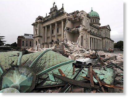
The aftershock struck 10km south of Christchurch and 10km west of Lyttelton at a depth of 5km, GeoNet reported.
There were no reports of damage, Radio New Zealand reported.
Meanwhile, a 4.5-magnitude earthquake rattled Wellington.
The quake struck at 10:07pm, and was centred 20km northwest of Wellington at a depth of 40km, GeoNet reported.
The quake was felt strongly as far north as Otaki and as far south as Blenheim.
There were no reports of damage, a Fire Service spokeswoman said.
The quake shook an area near the Geysers at 6:19 p.m. and had a depth of 1.6 miles, according to the USGS. That tremor was centered one mile north-northwest of The Geysers.
Tuesday, March 01, 2011 at 00:53:46 UTC
Monday, February 28, 2011 at 05:53:46 PM at epicenter
Time of Earthquake in other Time Zones
Location:
29.605°S, 112.107°W
Depth:
10 km (6.2 miles) set by location program
Region:
EASTER ISLAND REGION
Distances:
377 km (234 miles) SW of Hanga Roa, Easter Island
3931 km (2441 miles) W of SANTIAGO, Region Metropolitana, Chile

In this image provided by the Arkansas Geological Survey near Greenbrier, Ark., Thursday, Feb. 17, 2011, a seismic chart illustrating earthquake activity at Woolly Hollow State Park from noon to midnight on Feb. 16, is shown.
The U.S. Geological Survey recorded the quake at 11 p.m. Sunday, centered beneath the ground about four miles northeast of Greenbrier. It was the largest of more than 800 quakes to strike the area since September in what is now being called the Guy-Greenbrier earthquake swarm.
"You don't know what to expect. It's unnerving," said Corinne Tarkington, an employee at a local flower and gift shop. "I woke up last night to the sound of my house shaking."
What woke Tarkington was a magnitude 4.7 earthquake - the largest to hit the state in 35 years. No injuries or major damage have been reported, but the escalation in the severity of quakes in and around the small north-central Arkansas town has many residents on edge. Some said they're seeing gradual damage to their homes, such as cracks in walls and driveways.
"We probably had 40 to 50 calls last night," Greenbrier police Sgt. Rick Woody said, noting that the tone of the calls had changed. After previous quakes, most callers simply wanted to find out if a loud noise they'd heard was an earthquake, he said.