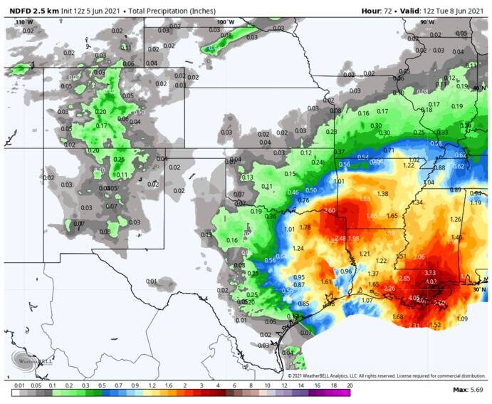
© WeatherBellThe Weather Service's forecast for heavy rainfall.
If you live along the western Gulf of Mexico coast, odds are that this spring had you ready to build an ark.
Some parts of Texas and Louisiana have seen more than 2½ feet of rainfall since the start of April, and more is on the way.Another three to six inches of rain, and maybe more in spots, is set to target already waterlogged areas through early next week. Flash flood watches are in effect for much of the Louisiana coastline.
In Texas, numerous rivers and streams have overtopped their banks due to recent rains, prompting
flood warnings for waterways in the zone from around Victoria to Beaumont.
Signs also point to a continued wet and rainy pattern over the upcoming week and a half, with continued bouts of rainfall set to renew flood concerns.
Scattered downpours and thunderstorms began lifting north across the greater Houston area around lunchtime Friday, and expanded in areal coverage and intensity throughout the afternoon and evening. A secondary batch of showers took shape in central and east coastal Louisiana and grew northward as well. Rainfall rates briefly topped two inches per hour.
Backbuilding storms dropped between two and three inches of water locally on the west side of Galveston Bay, prompting flash flood warnings on Friday.
On Saturday morning, a few isolated pop-up cells were drifting over East Texas and western Louisiana, but a slug of heavy rain was falling in eastern Louisiana. New Orleans had picked up a half-inch through 7 a.m.
The entire Louisiana coastline remains under a flash flood watch, with a broad three to five inches of rain likely through Sunday evening. A few spots could total half a foot or more, contributing to new flooding issues and exacerbating existing ones.
Hit-or-miss showers will last through the overnight into Sunday, at which point a more persistent band of downpours may develop and train, or sweep downpours over the same area, in southern Louisiana. That could bring about a local flooding bull's eye.
Farther west, only isolated to widely scattered, slow-moving thunderstorms are expected in Central and East Texas, leading to lower confidence as to where pockets of heavy rain could occur. One neighborhood may pick up a quick two or more inches while an adjacent one hardly sees a drop of water.
"Some clusters look possible and could bring about some street flooding, but the nearly unanswerable problem at this point is the where?" wrote the Weather Service in Houston.
The National Weather Service Weather Prediction Center, which specializes in precipitation forecasts, highlighted much of Louisiana as having an elevated risk of excessive rainfall and flooding. The agency noted that soil moisture in parts of Louisiana is already running at 150 to 200 percent of normal, with a few locales in Texas at 400 percent of the norm.
That means the ground is saturated and can't absorb much additional runoff.
The past few months have featured exceptional and, in some cases, extreme, rainfall totals. Flash flood emergencies were issued 2½ weeks ago in Baton Rouge and Lake Charles after serious flooding dropped over a foot of rain in hours. Lake Charles — which last August suffered a direct strike from Category 4 Hurricane Laura and then was battered by Hurricane Delta just over a month later — picked up 6.35 inches in two hours. Vehicles
succumbed to rising floodwaters, and some people were forced to
swim to higher ground. A rain gauge west of Lake Charles measured 15.07 inches.
In Baton Rouge, one person died when their vehicle hydroplaned; 13 inches of rain fell south of the airport.
Between April 1 and Thursday, Baton Rouge's airport had logged 27.69 inches of rainfall, 2½ times the average. New Orleans stands at 26.36 inches, and Lake Charles at 26.06 inches.
In Houston, April was dry, but nearly a foot of rain fell at Bush Intercontinental Airport during May. Hobby Airport picked up 10.3 inches.
The upcoming weather pattern continues to favor sporadic heavy rainfall for a few more days. A general two to four inches of rain is likely from eastern Central Texas, including Dallas, to the Louisiana border, around Monday. A drying trend is likely as high pressure dominates later next week.
Reader Comments
to our Newsletter