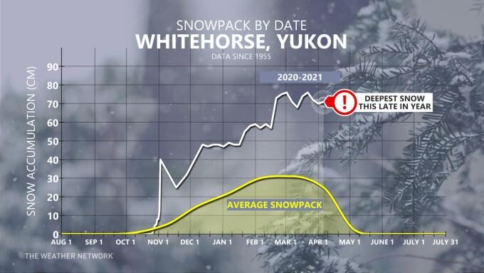
It snowed before Halloween, and it never really stopped snowing.
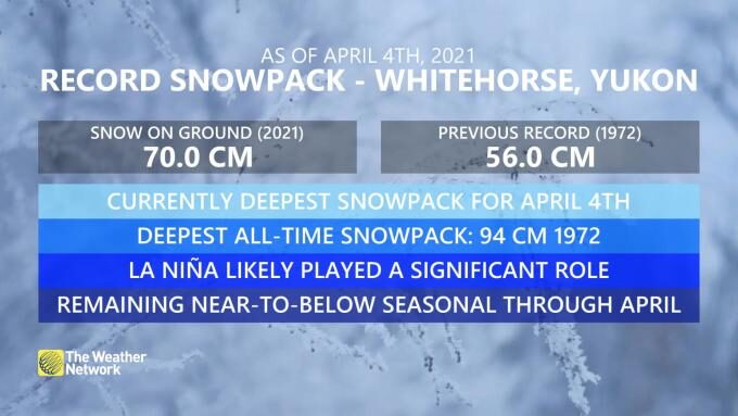
As of April 5th, there's 70 cm of snow on the ground across Whitehorse, Yukon; for the city of 25,000, it's a tremendous amount - the most on record for April 4th.
For reference, the snowpack usually peaks around 30 cm of snow, and by late April, the snow base remarkably diminishes to near zero. The sheer resiliency of the Yukon snowpack is quite peculiar.
The region was even greeted by a rare atmospheric river back in early December. It's typical to get a meandering Jet Stream in La Niña conditions, along with above-normal precipitation across parts. The atmosphere essentially behaved like an El Niño for January, limiting the amount of frigid air available in the region; when the active storm track kicked in, excess moisture moved into Yukon. It rarely was too cold to snow.
It's not a record deep snowpack, mind you. That goes to 1972, where 94 cm accumulated on the ground.
With temperatures expected to remain quite chilly over the next couple of weeks, some of the snow might inevitably survive the first couple of weeks of May.
A formidable shot of January-like cold is en route to Alaska and parts of northern Canada this weekend. Although the odds are low, Anchorage might see the chilliest temperature of the season - extraordinarily rare for April.
Expect to see a temperature below -20°C by Saturday a.m.
With the temperature barely dropping to freezing before midnight last night, Anchorage extends their run of days with freezing temps to 161 in a row - good for 9th place. Top 5 is not out of the question. @capture907 @AlaskaWx pic.twitter.com/b2yJi1UY7Y
— Brian Brettschneider (@Climatologist49) April 5, 2021
The city also can't catch a cold break, as it's in the midst of a streak of 161 days recording a temperature below the freezing mark. Yikes.
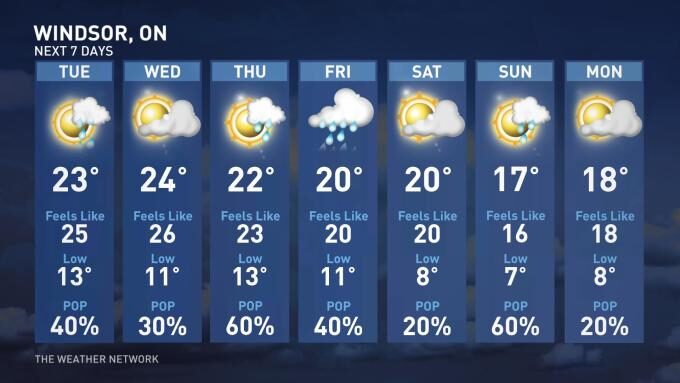
Contrast this with Windsor, Ont., which is flirting with some early summer vibes. Check out this tantalizingly warm seven-day forecast for the region.


Reader Comments
to our Newsletter