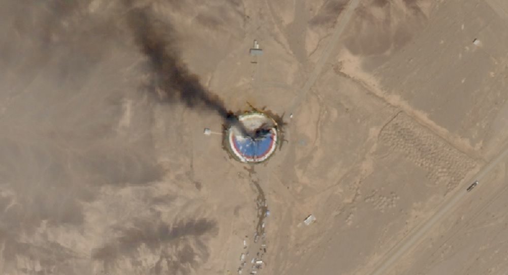
In a tweet posted Friday, US President Donald Trump posted a highly-detailed aerial photo of Iran's Semnan Space Center Launch Site One, damaged and charred after an explosion which supposedly happened during the fueling of a rocket.
"The United States of America was not involved in the catastrophic accident during final launch preparations for the Safir SLV Launch at Semnan Launch Site One in Iran. I wish Iran best wishes and good luck in determining what happened at Site One," Trump tweeted, accompanied by the photo.
Comment: Since no one actually accused the US of being "involved" in the event, why would Trump make this declaration? Similarly, one wonders Trumps motives for (potentially) 'accidentally' revealing unknown tech?
However, it was the photo that attracted the attention of viewers, as the launch site is depicted in uncommonly high resolution.
"I've never seen anything like this before," said David Schmerler, a leading expert on open-source imagery analysis, according to Business Insider. "I know that [the US military has] amazing capabilities, but I don't know what this is."
Ankit Panda, an adjunct senior fellow at the Federation of American Scientists who specializes in analyzing satellite images, says the photo could only have been taken by a highly-classified military satellite. According to Panda, no commercial satellite he knows of is capable of such high resolution. The WorldView-2 satellite, produced by Maxar, can only provide a 46-centimeter resolution, a National Public Radio report says.
"The resolution is amazingly high," says Panda. "I would think it's probably below well below 20 centimeters, which is much higher than anything I've ever seen."
Others, however, say that satellites have limitations, and suggest that the photo was taken from a drone.
"The atmosphere is thick enough that after somewhere around 11 to 9 centimeters, things get wonky," says Melissa Hanham, deputy director of the Open Nuclear Network at the One Earth Foundation.
But if it was a drone, this means either the US regularly violates Iranian airspace to spy or it has a drone so advanced it can fly well above national airspace. While the former revelation is likely to cause a political-military scandal, the latter means Trump just revealed another piece of highly-advanced and classified technology.
"These are closely held national secrets," Panda told National Public Radio. "We don't even share a lot of this kind of imagery with our closest allies."
He explained that the tweet revealed to Tehran a specific US military capability that can now be counteracted. "The Russians and the Chinese, you're letting them know that these are the kind of things that the United States has the capability of seeing," he says.
A US intelligence official confirmed to CNBC on Friday that Trump's tweet image comes from a classified intelligence briefing he received early in the day. The tweet sparked a storm of jokes about how Trump superseded the long and complicated bureaucratic process of declassifying intelligence by means of a simple phone-camera snap of the briefing (one can clearly see the phone flash on the photo). In the meantime, others engaged in online attempts to decipher what, when and where could have taken the photo.
Later on Friday, Trump defended his move, saying he had the "absolute right" to share the photo.
"I just wish Iran well. They had a big problem. And we had a photo and I released it, which I have the absolute right to do. And we'll see what happens," Trump said, according to The Hill.


Comment: See also: Putin details why Russia's military tech changes balance of power