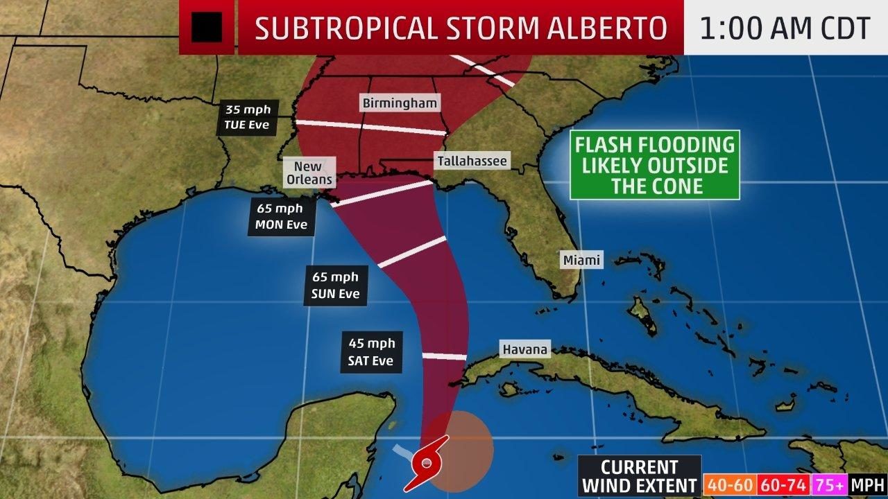
The red-shaded area denotes the potential path of the center of the system. It's important to note that impacts (particularly heavy rain, high surf, coastal flooding, winds) with any system usually spread beyond its forecast path.
While it's still way too early to tell if Alberto will gain enough steam as it crosses the Gulf of Mexico over the weekend, there's a chance the storm could become the earliest land-falling hurricane on record.
Forecasts now call for top winds of 65 mph, 9 mph below the threshold for a Cat 1 hurricane, by Monday when it's near the north Gulf Coast. But shear is expected to drop, with some models opening a window just big enough for a more intense system to develop.
"This thing could become a hurricane," said AccuWeather senior meteorologist Dan Kottlowski, "and people should think about that possibility as it approaches the northern Gulf Coast."
If it does, Alberto would be the first since Alma appeared north of Panama in 1970 and briefly threatened the Caribbean for two days before fizzling south of Cuba.
Hurricanes rarely form so early because ocean waters are usually too cool, said Phil Klotzbach, a meteorologist with Colorado State University's Tropical Meteorology Project which issues a popular preseason forecast based on historical trends. But the Gulf provides a perfect pocket where conditions can collide to create a hurricane-inducing environment.
"The Gulf is one of the places where stuff is warm enough," he said.
Aside from Alma, five other May hurricanes have been recorded in the last two centuries. The end of the season, when summer heat drags on, is more likely to burp out a late finale, with twice as many occurring. Storms and depressions form far more often. More than four dozen occurred in April and May.
At this point, Alberto is still classified as a subtropical storm, a kind of hybrid, lopsided system created in part by cool air lingering in the upper atmosphere from a late season blast out of the northeast. Which is also rare, Klotzbach said. It's the first subtropical system to appear so far south since Olga in 2007, he said. Why? Because cool air is also rare this late in the year.
As it rolls north, forecasters expect Alberto to transition to a pure tropical storm over warm waters, allowing it to become better defined. For the record, Klotzbach is not completely convinced a hurricane could happen, just a jittery open to the season, which officially starts June 1.
"Given last year and the amount we had, people are freaking out already. And it's not just the general public," he said. "I have a friend in insurance and he says all the insurance people are freaking out."


Reader Comments
to our Newsletter