Irma's behavior has been remarkably steady over the last couple of days. At least one eyewall replacement cycle has occurred, a process that can lead to short-term weakening followed by a restrengthening a day or two later as the new eyewall takes over. Since Friday, Irma's top sustained winds have oscillated within the 110-120 mph range, crossing the boundary between Category 2 and 3 strength several times. As of 5:00 pm EDT, Irma's estimated top winds were 115 mph. The first Hurricane Hunter flight into Irma, which was in progress Sunday evening, found a dropsonde-measured surface pressure of 961 millibars and a remotely-estimated pressure of 958 mb, both of which are considerably lower than the 5 pm NHC estimate of 969 mb. Surface winds of 113 mph were estimated in the northeast eyewall.
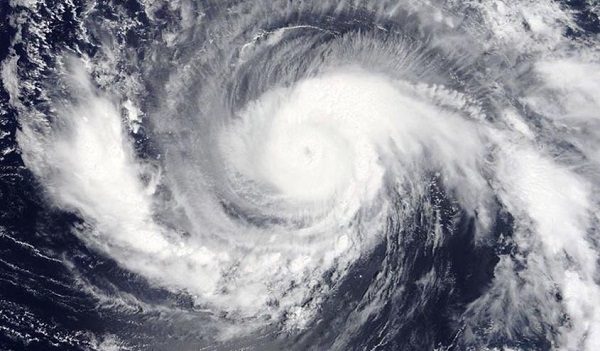
Irma has healthy upper-level outflow in all directions (see Figure 1), which is one important measure of a hurricane's potential for growth. Irma is also getting larger-a trend that may continue all week-with tropical-storm-force winds now extending out up to 140 miles on its north side.
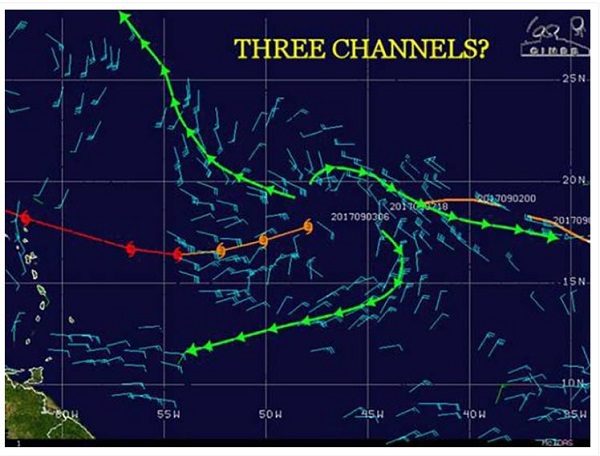
Irma has been angling west-southwest since Saturday. That general motion is expected to continue through Monday, until Irma rounds the base of an upper-level ridge and heads west-northwest. The timing and angle of that turn is crucial to potential impacts on the Leewards. The official NHC track as of 5 pm EDT Sunday brings Irma's center within 100 miles of Anguilla by Wednesday afternoon and very near the Turks and Caicos Islands by late Thursday into Friday.
Outlook for Irma for the week ahead
Computer model guidance through Friday has been increasingly consistent on Irma's arcing path. There is a good chance Irma will pass just north of Puerto Rico and Hispaniola, but the track will be close enough to demand vigilance. The model consistency also suggests that Irma is likely to track over or near the Turks and Caicos Islands and into at least eastern parts of The Bahamas by Friday or Saturday. This is obviously a concern for residents there, and it also raises concerns about Irma's longer-term future. Some of the strongest hurricanes in western Atlantic history have reached their peak intensities while passing through or near the very warm waters of the Eastern Bahamas. Sea surface temperatures (SSTs) are even warmer than usual here-around 29°C (84°F), or roughly 0.5°C above average for this time of year. Moreover, the warmth extends to great depths, leading to unusually high values of oceanic heat content (see Figure 2). High ocean heat content helps keep hurricanes from churning up cooler waters that might impede their growth.
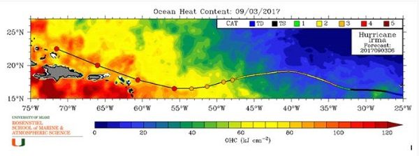
Competing factors have kept Irma's strength fairly steady over the last couple of days, with low wind shear of 5-10 knots (supportive of strengthening) but SSTs only marginally warm (about 27-28°C or 81-82°F) and mid-level relative humidities on the dry side (about 50-55%). As noted above, SSTs along Irma's path will be rising to around 29°C over the next couple of days, and mid-level RH should be increasing to around 60-65%. Wind shear will also be increasing, to around 10-15 knots, but Irma should be able to fight off the effects of this amount of shear given the other factors in its favor.
Several computer models have been confronting meteorologists with some eye-opening intensity forecasts for Hurricane Irma, especially for the period around next weekend, when Irma is currently predicted to be arcing northwest from the Eastern Bahamas. We cannot rule out the chance that Irma will reach Category 5 strength, but we can safely discount some of the most extreme model-generated intensities. The GFS global model and the new HMON regional hurricane model have consistently been deepening Irma to pressures below 900 millibars (mb). However, neither of these models fully incorporates the interaction between ocean and atmosphere that serves as a check on a hurricane's peak strength. A better guide to how strong Irma might get is the European global model and the HWRF regional hurricane model, which extends out to 126 hours (just over five days). The HWRF, in particular, has proven to be our most reliable model-based intensity guidance in recent years. The 0Z and 12Z Sunday operational runs of the European model deepen Irma to the 920-930 mb range, and the 0Z, 6Z, and 12Z runs of the HWRF show similar intensities. Even these less-extreme numbers are nothing to sneeze at: they suggest Irma will be a very formidable hurricane.
For historical context, the lowest hurricane-related pressure ever measured at the surface north of the Caribbean and east of Florida is 921 mb in the Bahamas Hurricane of 1932. Hurricane Hunter dropsondes found a surface pressure of 919 mb within Hurricane Gloria (1985). Such pressures can support a Category 4 or 5 hurricane, but the peak winds depend on the size of the hurricane. As hurricanes move poleward, they typically get bigger. In a larger hurricane, the pressure force from a given central pressure will extend over a larger area, meaning that the top sustained winds will probably be lower but that a larger area could experience high winds and storm surge. This was the case with Hurricane/Superstorm Sandy, which brought record-low surface pressures and record-high surge across a large area despite winds of marginal hurricane force at best.
Long-range track outlook
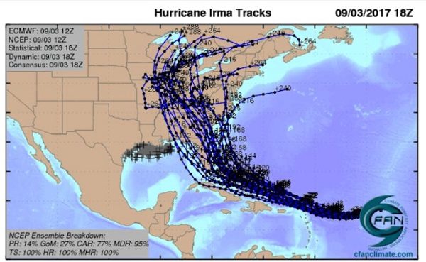
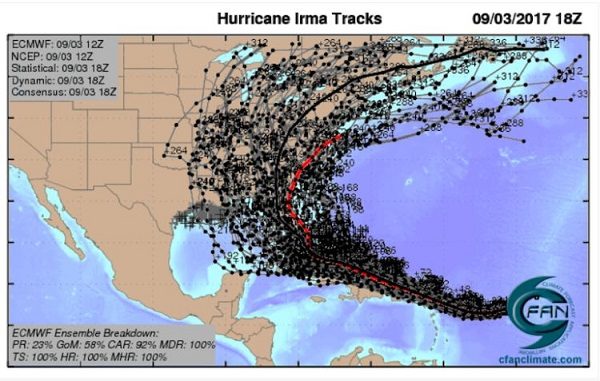
Beyond Friday, there is greater model divergence on what will happen with Irma's track-no surprise, given that the typical error in track forecasts goes up significantly in this time frame. Over the last day, there has been some convergence of two of our best long-range track models, the GFS and European models, toward a possible landfall in or near the Carolinas around Monday. Both models are consistent in bringing a strong upper-level trough across the United States and off the East Coast by this weekend. The models also suggest that a small weakness will be left behind, somewhere near the lower- to mid-Mississippi Valley. If so, this could help bring Irma toward the United States. However, the path of least resistance for Irma might instead be toward the large departing trough and out to sea into the Northwest Atlantic. These two scenarios have hugely different implications, but they depend on fairly subtle differences in the atmosphere that may not become clear for several more days to come.
As shown in Figures 5, 6, and 7, there remains a wide spread of possibilities in the GFS and Euro ensemble runs (which are produced by carrying out multiple runs of the same model, using small variations in the starting-point data to mimic uncertainty in our observations). Moreover, the 12Z Sunday operational run of the European model takes Irma out to sea before a U.S. landfall-another sign that it is way too soon to predict Irma's track beyond late this week with any confidence.
Bottom line: Irma is a growing threat to the Leeward Islands, the Greater Antilles, and the Eastern Bahamas. Irma is expected to be drawing closer to the East Coast as a powerful Category 4 hurricane this weekend, but it is still too soon to predict the timing and location of any potential landfall with confidence, and it is still possible Irma will move out to sea.
New tropical depression possible in the central Atlantic
A tropical wave located about 300 miles southwest of the Cabo Verde Islands on Sunday afternoon was moving west at about 10 mph. Satellite images on Sunday afternoon showed the wave had a modest amount of spin, but heavy thunderstorm activity was thin and poorly organized. Conditions were favorable for development, with low wind shear of 5 - 10 knots, SSTs near 28°C (82°F), and a moist surrounding atmosphere.
The 0Z and 12Z Sunday operational runs of our three reliable models for predicting tropical cyclone genesis-the GFS, European and UKMET models-had two of the three, the European and UKMET, predict development of this wave by mid-week, over the central tropical Atlantic. The GFS model delayed development until Friday, when it predicted the system would be close to the Lesser Antilles Islands. Over 40% of the 70 forecasts from the 0Z Sunday GFS and European model ensemble predicted development. The wave will move west to west-northwest over the coming week, and residents of the Lesser Antilles Islands should keep an eye on this system. In its tropical weather outlook issued at 2 pm EDT Sunday, the National Hurricane Center gave this system 2-day and 5-day odds of development of 0% and 60%, respectively. The next name on the Atlantic list of storms is Jose.
If Jose develops and ends up within about 850 miles of Irma, it is possible that the two systems will influence each other's tracks via the Fujiwhara phenomenon. This could push Irma's track slightly toward the southwest and Jose's track slightly northeast. If Jose does develop, the physics within global models would account for such interaction in their track forecasts.
Gulf of Mexico disturbance not expected to develop
A trough of low pressure in the southwestern Gulf of Mexico's Bay of Campeche is producing disorganized heavy thunderstorms. SSTs are very warm, but wind shear is moderate to high, 10 - 25 knots, and none of our reliable models for predicting tropical cyclone genesis develop the system over the next five days. About 40% of the 50 members of the 0Z Sunday European model ensemble developed the system, and about 10% of the GFS ensemble members did so. These model runs generally kept the system bottled up in the southwestern Gulf of Mexico. In its tropical weather outlook issued at 2 pm EDT Sunday, the National Hurricane Center gave this system 2-day and 5-day odds of development of 10%.


Comment: There are hurricane watches in place for Puerto Rico and Floridians are being warned to prepare: