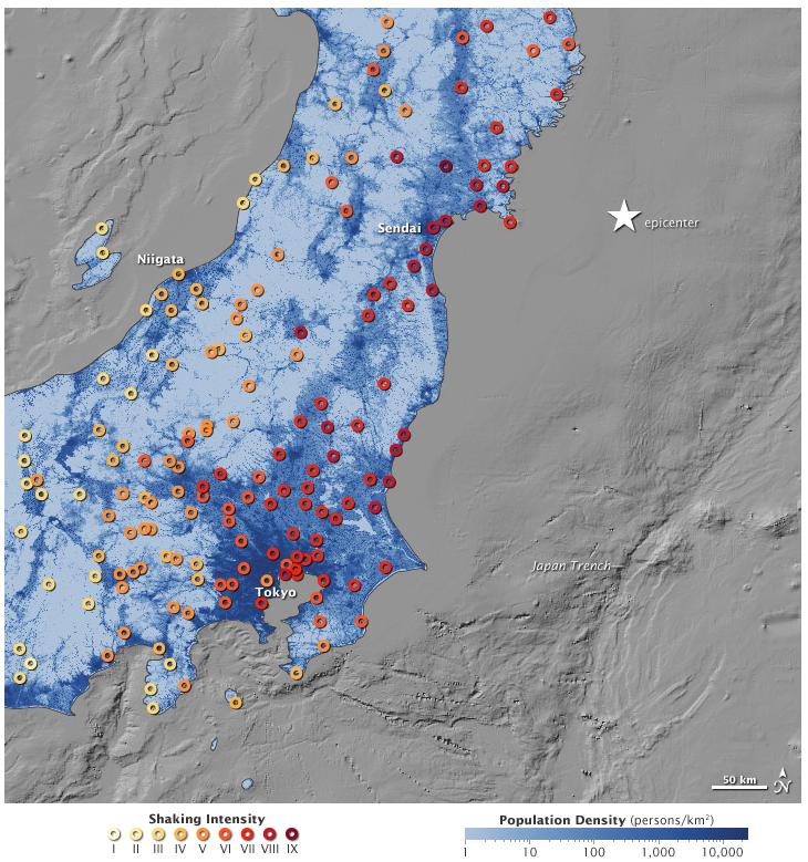
This map shows the ground motion and shaking intensity from the earthquake at dozens of locations across Japan. Each circle represents an estimate of shaking as recorded by the USGS, in conjunction with regional seismic networks. Shades of pale yellow represent the lowest intensity and deep red represents high intensity. The ground shaking data is overlaid on a map of population density provided by Oak Ridge National Laboratory.
A shaking intensity of VI is considered "strong" and can produce "light damage," while a IX on the scale is described as "violent" and likely to produce "heavy damage." The pattern of shaking appears to run parallel to the offshore subduction trench, with the intensity decreasing more from east to west, as opposed to north and south. Ground motion also seems to be more intense in coastal and riverine areas, where settlements are built on softer sediments and less bedrock.
Note the number of VIIs and VIIIs near Tokyo, well away from the epicenter; the lack of a severe human toll in that metropolitan area is surely a testament to the quality of the nation's earthquake preparedness.
In the week after the main quake, Japan endured 262 aftershocks of at least magnitude 5, according to JMA. Forty-nine of them were magnitude 6 or greater, and three were magnitude 7 or higher. (For comparison, the Christchurch earthquake of February 2011 was a magnitude 6.3.) The aftershocks have been almost entirely offshore, in a zone stretching about 500 kilometers (300 miles) from Iwate to Ibaraki prefectures.
References
- Japanese Meteorological Agency (2011). The 2011 off the Pacific coast of Tohoku Earthquake. Accessed March 18, 2011.
- Kyodo News (2011, March 19). Record aftershocks registered in Japan after March 11 quake. Accessed March 18, 2011.
- USGS (2011) Magnitude 9.0-Near the Coast of Honshu, Japan. Accessed March 18, 2011.
- USGS (n.d.) Shake Maps. Accessed March 18, 2011.


Reader Comments
to our Newsletter