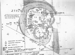
How big was the meteorite? The best guess is that it or perhaps it was a comet ice mass left a circular crater dome measuring about 4 ½ miles in diameter. The entire "disturbed area" is about eight miles in diameter.
The meteorite hit with such force and velocity that, as it plunged into the earth, it lifted Shakopee dolomite (rock resembling limestone from the Ordovician period) up to the planet's surface from some 2,000 feet below. Much of this rock then stood vertically rather than horizontally. Eventually, over the eons, glaciers and water eroded away much of the crater, but still leaving numerous stone outcroppings.
It became what modern-day meteorologists and geologists call the Kentland Crater, the fourth largest known impact site in the United States. They've been studying the crater for the past 70 years.
Here's the time to explain that, despite the evidence, some believe what happened was not a meteorite strike but rather an earthquake or explosion of gases erupting up through the earth's surface.

Interest in the crater remains so strong that Susan Daniel, community relations coordinator for the company, spends considerable time conducting tours and answering questions about the crater.
While school children show up by the bus loads and geologists and meteorologists still beat a path to the crater site, interestingly enough many Hoosiers never have heard of it. As a matter of fact, I've mentioned it to perhaps as many as 50 persons and only one had any idea what I was talking about.
Nor is visiting the crater site the easiest thing to do.
If the area has had recent rain, passage down into the quarry becomes difficult. My friend Howie Snider and I had to cancel three proposed trips because of rain. Certainly you want to call Susan Daniel to make arrangements for your visit.
Finally, we had a good day. After showing us some rocks from the quarry and explaining how the operation functions, Susan piled Howie and me into her truck and away we went. First we traveled down in the quarry to the raised platform where visitors usually are taken. It provides a panoramic view.
I'm not sure I can describe the other twists and turns we took as we explored other parts of the quarry. I was especially looking for photo possibilities showing the vertical rock structure still visible in a number of quarry walls.
Hard to believe but two hours had passed by the time when we returned to the quarry office.


Reader Comments
to our Newsletter