Earthquakes
S


Seismograph

Magnitude 6.6 earthquake strikes off Indonesia's Java island

maps
The United States Geological Survey (USGS) has said that a 6.6-magnitude earthquake struck off the coast of Indonesia's Java island on Friday, causing buildings in Jakarta to shake.

At 0905 GMT, the quake struck to the island's southwest at a depth of 37 kilometres (23 miles).

The tremor was felt in the capital and rattled buildings. No tsunami warning was issued, and there were no early reports of injuries or damage.

Following the quake, some Jakarta residents were evacuated from their homes, and hundreds waited outside.


Seismograph

Shallow 6.0 magnitude earthquake in northern Mid-Atlantic Ridge

grpaph
UTC time: Monday, January 10, 2022 23:26 PM
Your time: Monday, January 10, 2022, 11:26 PM GMT
Magnitude Type: mww
USGS page: M 6.0 - northern Mid-Atlantic Ridge
USGS status: Reviewed by a seismologist
Reports from the public: 1 person
10 km depth

Seismograph

2 powerful earthquakes of magnitudes 6.8 and 6.6 hit Alaska - 3 of such strength globally within 12 hours

maps
6.6 magnitude earthquake 175 km from Unalaska, Alaska, United States

UTC time: Tuesday, January 11, 2022 12:39 PM
Your time: Tuesday, January 11, 2022, 12:39 PM GMT
Magnitude Type: mww
USGS page: M 6.6 - 60 km SE of Nikolski, Alaska
USGS status: Reviewed by a seismologist
Reports from the public: 4 people

11 km depth

Comment: These latest powerful quakes follow closely on the heels of another of similar strength off the coast of Cyprus about 12 hours earlier.


Seismograph

Best of the Web: Cyprus earthquake: Powerful 6.6 magnitude tremor rocks region shaking homes

maps
A powerful earthquake measuring 6.6 has sent tremors across a region around Cyprus in the Mediterranean with reports of people feeling their houses shake.

The quake was at a depth of 2 km (1.24 miles), said the European Mediterranean Seismological Centre (EMSC).

It was centred 30 miles west-northwest of the town of Polis in Cyprus around 1am local time and the tremor was felt across the island and the region, including reports from as far away as Turkey, Israel and Lebanon.

There are no reports of damage or injuries.

But people have taken to social media having felt the force of the earthquake.


Comment: If confirmed as a 6.6M, it would be the strongest earthquake on the island since 1996.


Seismograph

Shallow 6.2 magnitude earthquake off Kermadec Islands

maps
Very strong magnitude 6.2 earthquake at 10 km depth

Date & time: Jan 10, 2022 00:06:31 UTC - 20 hours ago
Local time at epicenter: Sunday, Jan 9, 2022 12:06 pm (GMT -12)
Magnitude: 6.2
Depth: 10.0 km
Epicenter latitude / longitude: 33.7964°S / 179.5534°E

Info

Geomythology looks to ancient stories for hints of scientific truth

Everyone loves a good story, especially if it's based on something true.

Consider the Greek legend of the Titanomachy, in which the Olympian gods, led by Zeus, vanquish the previous generation of immortals, the Titans. As recounted by the Greek poet Hesiod, this conflict makes for a thrilling tale - and it may preserve kernels of truth.

The eruption around 1650 B.C. of the Thera volcano could have inspired Hesiod's narrative. More powerful than Krakatoa, this ancient cataclysm in the southern Aegean Sea would have been witnessed by anyone living within hundreds of miles of the blast.
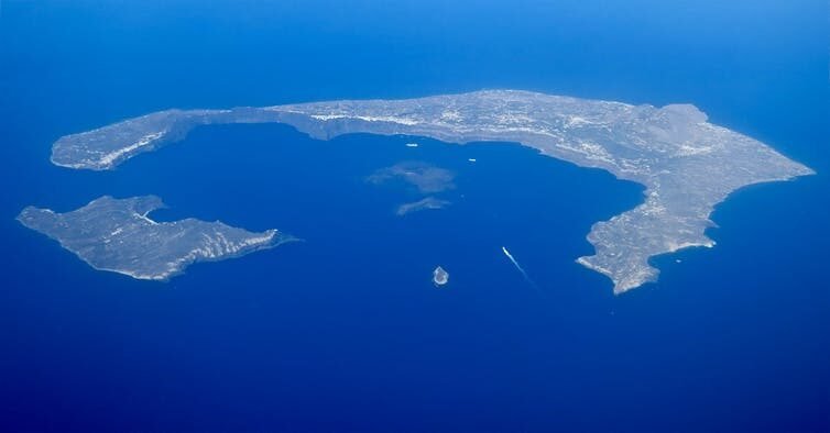
Thera Volcano
© Steve Jurvetson, CC BYThe massive eruption of the Thera volcano more than 3,500 years ago left behind a hollowed out island, today known as Santorini.
Historian of science Mott Greene argues that key moments from the Titanomachy map on to the eruption's "signature." For example, Hesiod notes that loud rumbles emanated from the ground as the armies clashed; seismologists now know that harmonic tremors - small earthquakes that sometimes precede eruptions - often produce similar sounds. And the impression of the sky - "wide Heaven" - shaking during the battle could have been inspired by shock waves in the air caused by the volcanic explosion. Hence, the Titanomachy may represent the creative misreading of a natural event.

In 2021 I published the first textbook in the field, Geomythology: How Common Stories Reflect Earth Events. As the book demonstrates, researchers in both the sciences and the humanities practice geomythology. In fact, geomythology's hybrid nature may help to bridge the gap between the two cultures. And despite its orientation toward the past, geomythology might also provide powerful resources for meeting environmental challenges in the future.

Seismograph

Strong shallow 6.6-magnitude earthquake hits China's Qinghai province: USGS

maps
The epicentre of the quake, which struck at about 1:45 am at a shallow depth of 10km

A strong earthquake with a magnitude of 6.6 struck China's remote northwestern Qinghai province early Saturday, the US Geological Survey said.

The epicentre of the quake, which struck at about 1:45 am (1745 GMT) at a shallow depth of 10 kilometres (six miles), was located about 140 kilometres north-northwest of the city of Xining, US seismologists said.


Source: AFP

Seismograph

Strong magnitude 6.1 earthquake shakes Nicaragua

mapped
A strong earthquake shook Nicaragua Thursday morning, sending people fleeing into the streets, but there were no initial reports of damage.

The U.S. Geological Survey said the earthquake had a preliminary magnitude of 6.1 — down from an initial calculation of 6.2. It was centered on the country's Pacific coast about 36 miles (59 kilometers) south of Corinto. The earthquake was at a depth of 17 miles (27.5 kilometers).

It was felt strongly in Managua, the capital, where residents milled about outside their homes and workers cleared government buildings. Travelers at the capital's international airport were evacuated from the terminal.

The earthquake, which hit at 10:25 a.m. (11:25 a.m. EST; 1625 GMT), was also felt to the north in El Salvador.

Vice President and first lady Rosario Murillo told government media that despite the earthquake's strength there had been no immediate reports of victims nor damage.

Source: AP

Seismograph

Strong mag. 6.0 earthquake - Banda Sea, Indonesia

maps
Strong magnitude 6.0 earthquake at 556 km depth

Date & time: Jan 4, 2022 20:55:47 UTC - 15 hours ago
Local time at epicenter: Wednesday, Jan 5, 2022 5:55 am (GMT +9)
Magnitude: 6
Depth: 556.2 km
Epicenter latitude / longitude: 4.7993°S / 125.0518°E (Banda Sea, Indonesia)

Seismograph

Strong magnitude 6.1 earthquake - North Atlantic Ocean

mapped
Very strong magnitude 6.1 earthquake at 10 km depth

Date & time: Jan 4, 2022 03:18:37 UTC - 6 hours ago
Local time at epicenter: Tuesday, Jan 4, 2022 1:18 am (GMT -2)
Magnitude: 6.1
Depth: 10.0 km
Epicenter latitude / longitude: 35.2646°N / 35.2407°W