Earthquakes
S


Seismograph

Shallow 6.3 magnitude earthquake in southern Indian Ocean

graph
6.3 magnitude earthquake

UTC time: Friday, February 04, 2022 20:25 PM
Your time: Friday, February 4, 2022, 8:25 PM GMT
Magnitude Type: mww
USGS page: M 6.3 - southeast Indian Ridge
USGS status: Reviewed by a seismologist
Reports from the public: 0 people

10 km depth

Seismograph

6.5 magnitude earthquake strikes northern Peru near Ecuador border, USGS says

quake
A preliminary-magnitude 6.5 earthquake struck northern Peru near the Ecuador border region on Thursday morning, the US Geological Survey said.

The quake occurred shortly before 11 a.m. and was centered about 32 miles northwest of Barranca and 110 miles north of Rioja, according to the USGS. Whether it resulted in any significant injuries or damage was not immediately clear.

The temblor's depth was measured at about 62 miles.

Seismograph

Shallow magnitude 6.5 earthquake in the Kermadec Islands region

maps
6.5 magnitude earthquake

UTC time: Saturday, January 29, 2022 02:46 AM
Your time: Saturday, January 29, 2022, 2:46 AM GMT
Magnitude Type: mww
USGS page: M 6.5 - Kermadec Islands region
USGS status: Reviewed by a seismologist
Reports from the public: 2 people

10 km depth

Seismograph

Shallow 6.1 magnitude earthquake off Panama

maps
6.1 magnitude earthquake 282 km from Punta de Burica, Chiriquí, Panama

UTC time: Friday, January 28, 2022 11:14 AM
Your time: Friday, January 28, 2022, 11:14 AM GMT
Magnitude Type: mww
USGS page: M 6.1 - 282 km SW of Arenas, Panama
USGS status: Reviewed by a seismologist
Reports from the public: 3 people

10 km depth

Seismograph

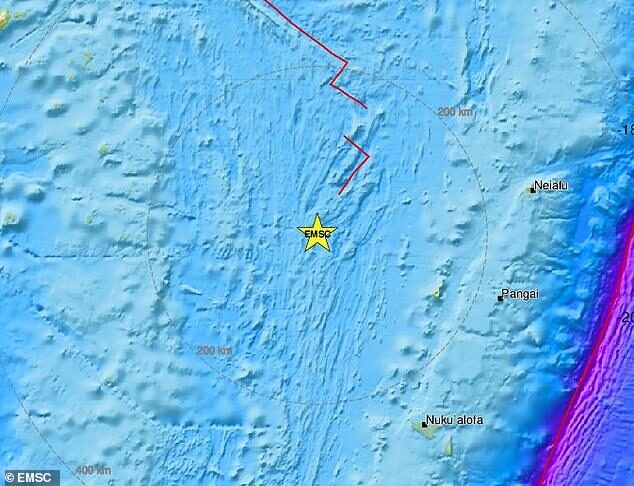
Tonga region hit by magnitude 6.2 earthquake just weeks after huge volcanic eruption and tsunami devastated the islands

A magnitude 6.2 earthquake has struck an area of the Pacific Ocean located around 130 miles from the island of Lifuka, which forms part of Tonga
Tonga has been rocked by a magnitude 6.2 earthquake, just weeks after a devastating volcanic eruption and tsunami.

The quake struck 130 miles west of the island of Lifuka around 7.40pm local time on Thursday, the United States Geological Survey said.

Lifuka is part of the low-lying Haʻapai Islands chain which was hard-hit in the Hunga-Tonga eruption, with several of the islands seeing all their buildings swept away in the subsequent tsunami.

There was no immediate word on damage from Thursday's earthquake, with communications in the region still badly disrupted after the eruption severed an underwater internet cable that is still being repaired.

However, the National Weather Service located in nearby American Samoa said no tsunami had been caused - meaning any damage is likely to be limited.

Seismograph

Haiti earthquakes kill two, send residents flooding into the streets

MAPS
Haiti was struck by a 5.3 magnitude earthquake and a series of smaller tremors on Monday that killed two people and led panicked residents of the Caribbean nation's southern peninsula to flood into the streets.

The U.S. Geological Survey reported that the first quake hit an area near the city of Les Cayes and was followed by tremors of 4.4 and 5.1 in the same area, just six months after a major tremor in the same region killed more than 2,000 people.

One person died in Fond des Nègres and a second in Anse-à-Veau, where 35 homes were destroyed, Haiti's civil protection authority said in a tweet, adding that a road and a bridge had also been destroyed.

Jean Robert Léger, a resident of the town of Pestel on the southern peninsula, said the impact appeared to be minimal.

Seismograph

Magnitude 6 earthquake - South Atlantic Ocean, South Sandwich Islands

maps
Very strong magnitude 6.0 earthquake at 11 km depth

Date & time: Jan 25, 2022 01:24:33 UTC - 10 hours ago
Local time at epicenter: Monday, Jan 24, 2022 11:24 pm (GMT -2)
Magnitude: 6
Depth: 11.0 km
Epicenter latitude / longitude: 55.388°S / 28.7949°W

Bizarro Earth

Why no one is freaking out about the looming massive earthquake threat in the Pacific Northwest

A monstrous earthquake in the Pacific Northwest is a certainty. We just don't know when.
Earthquake Illustration
© FINGERMEDIUM / GETTY IMAGES
For many people, natural disasters inspire both fascination and fear. They're a sign of nature's power to not only create, but also destroy. At the same time, they're a reminder of the human potential for ingenuity when it comes to protecting ourselves from the forces we cannot control.

In this case, there are two opposing forces: the North American Plate, an enormous tectonic plate that carries the entire continental United States on its back, versus the 90,000-square-mile Juan de Fuca Plate, located in the ocean off Washington, Oregon, and Northern California. For the past 200 million years, these two have been squaring off in an epic wrestling match in an area known as the Cascadia Subduction Zone, or CSZ. Trust us, nobody wants to see the end of this round. Yet only a few people seem truly bothered: seismologists, emergency management professionals, and those who have experienced earthquakes before.

It's certain that the Northwest will experience a devastating earthquake again, says Chris Goldfinger, an oceanographer at Oregon State University and one of the world's leading experts on subduction zone earthquakes. "We have no idea of the timing and how urgent it is," Goldfinger tells Pop Mech. "People tend to ignore it in that case." The majority of the public, as well as most governments in the Northwest, aren't yet pushing to implement the extensive infrastructure changes and early-warning communications systems needed to save tens of thousands of lives.

The Juan de Fuca Plate has been steadily pushing against the Pacific Coast as it slides beneath the North American Plate. But the roughly 47-million-square-mile North American Plate isn't budging. Instead, it's locked tightly against the Juan de Fuca's surface.
Seismograph

Magnitude 6.2 earthquake strikes near Unalaska, Alaska

maps
A magnitude 6.2 earthquake struck south of Unalaska in Alaska, a major fishing port with 4,700 full-time residents, on Friday, the Alaska Earthquake Center at the University of Alaska Fairbanks said.

The quake struck at 8:17 p.m. (0517 GMT on Saturday), the center said.

The United States Geological Survey (USGS), which registered the quake at 6.2 magnitude, said it struck 74 km (46 miles) south of Unalaska at a depth of 3 km (2 miles).

The U.S. Tsunami Warning System said there was no tsunami warning after the quake.

(Reporting by Akriti Sharma in Bengaluru and Yereth Rosen; Editing by William Mallard)

Source: Reuters

Seismograph

Magnitude 6 quake strikes Talaud Islands, Indonesia

maps
An earthquake of magnitude 6 struck the Talaud Islands in Indonesia on Saturday, the GFZ German Research Center for Geosciences (GFZ) said.

The quake was at a depth of 24 km (15 miles), GFZ said.