Earthquakes
S


Info

Searching for earthquakes in the Ionosphere

Earthquake Damage
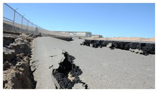
© Adam DuBrowa/FEMAA magnitude 7.2 earthquake damaged roads across northwestern Mexico and Southern California (like this one in Calexico) when it struck on 4 April 2010.
In 2010, at 40 minutes past 3:00 in the afternoon on 4 April — Easter Sunday — northwestern Mexico started to shake. A magnitude 7.2 earthquake was rattling the Baja California region, ultimately causing three deaths and more than 100 injuries. The quake caused widespread damage in the border cities of Mexicali, Mexico, and Calexico, Calif. The quake made skyscrapers sway in San Diego, more than 160 kilometers west.

The earthquake sent waves through the ground around it, but high in the atmosphere, a very different sort of perturbation might have offered a forewarning of the earthquake's impending arrival, had anyone been able to see it. Subtle fluctuations in Earth's ionosphere, a region of charged particles high above the surface, preceded the Baja earthquake, said the authors of a new paper published in Advances in Space Research. Somehow, the fault that caused the earthquake may have been telegraphing its impending rupture, sending out a rush of electrically charged particles that resonated in the ionosphere.

The ionosphere, which begins about 48 kilometers above Earth's surface and stretches to around 965 kilometers, is where incoming energy from the Sun ionizes molecules in the atmosphere, knocking off electrons. The abundance of charged particles means the ionosphere reacts to electric and magnetic fields, something other regions of the atmosphere generally do not do.

Using data from the Massachusetts Institute of Technology's Haystack Observatory on the density of electrons in the ionosphere, a team of Chinese and U.S. researchers analyzed the atmosphere above the Baja California region for 72 days both before and after the earthquake. After controlling for other things that might have been affecting the ionosphere, they said they saw a clear anomaly — a spike in the number of ionospheric electrons — on 25 March, 10 days before the earthquake. The electron spike was located over the earthquake's epicenter, and it didn't look like anything else they'd seen in the data.

We can imagine it to be something like ripples in a lake, said Chen Zhou, a researcher at Wuhan University in China and a coauthor of the paper. The electron signal looked like a brief, but telling, redistribution of particles from their normal movements and positions, one researchers were able to catch as it went by.

Zhou and his colleagues said their work could support a theory that faults release electrical energy in the days leading up to an earthquake. How exactly this happens isn't clear — some scientists think it's the result of radon gas released by a fault ionizing air molecules, whereas others hold that rocks under stress can release bursts of electrons.
Seismograph

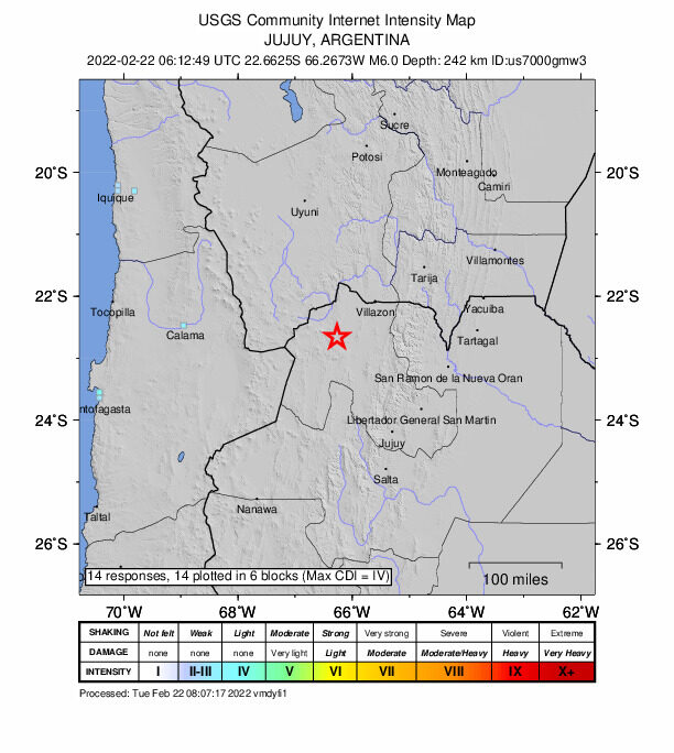
Magnitude 6.0 earthquake hits Argentina

maps
A magnitude 6.0 earthquake struck Argentina on Tuesday.

No material damage or casualties have been reported so far.

The quake's epicenter was 58 kilometers (36 miles) west of Abra Pampa, a town in the northwestern Jujuy province, at a depth of 242 kilometers (150 miles), according to the US Geological Survey (USGS).

Seismograph

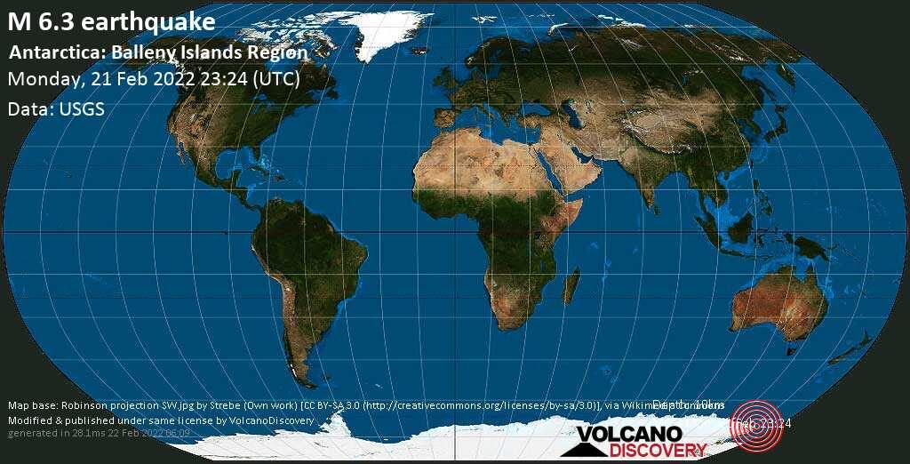
Strong shallow magnitude 6.3 earthquake near Balleny Islands off Antarctica

maps
Very strong magnitude 6.3 earthquake at 10 km depth

Date & time: Feb 21, 2022 23:24:12 UTC
Local time at epicenter: Tuesday, Feb 22, 2022 at 12:24 pm (GMT +13)
Magnitude: 6.3
Depth: 10.0 km
Epicenter latitude / longitude: 69.7601°S / 165.4321°E (South Pacific Ocean, Antarctica)

Bizarro Earth

Geologists map 9.0 magnitude quake's impact on the Cascadia subduction zone

CAscadia Subduction Zone
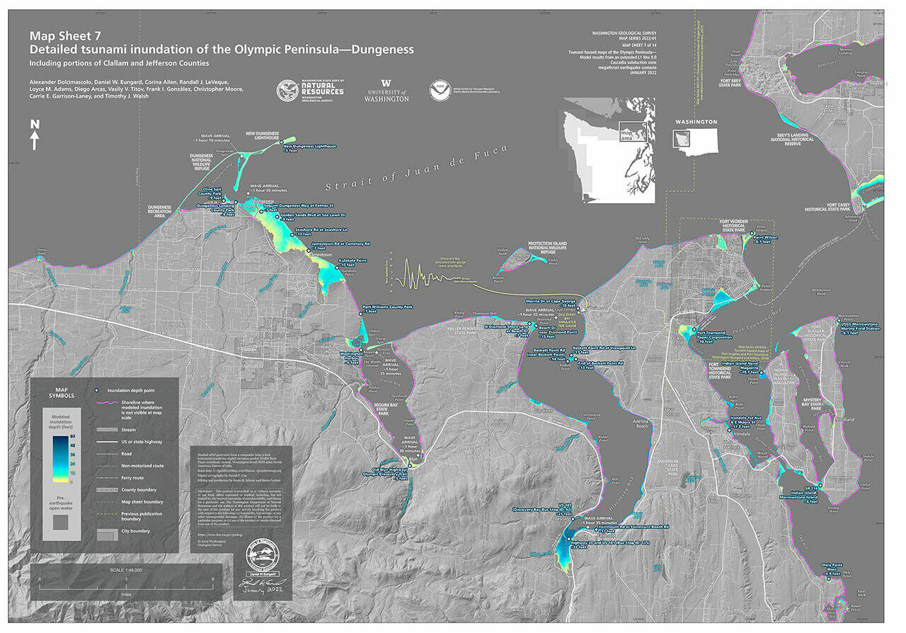
© Photo courtesy of Department of Natural ResourcesNew maps from the Department of Natural Resources show the potential flooding impact from a tsunami caused by a 9.0 earthquake along the Cascadia subduction zone.
New maps through a study by geologists with the Washington Geological Survey division of the Washington Department of Natural Resources show that a 9.0 magnitude earthquake could be devastating to the state's coastlines and roadways, including along the entirety of the Olympic Peninsula.

The new study, which became available days after the undersea volcanic eruption by Tonga on Jan. 15, uses a simulated magnitude 9.0 earthquake on the Cascadia subduction zone, according to DNR staff.

Geologists predict the first tsunami waves could reach La Push 10 minutes from the start of the earthquake, and Washington's Pacific coast in about 30 minutes.

Port Angeles would see waves about an hour from the earthquake's start, Dungeness at about 80 minutes, Miller Peninsula about 85 minutes, Blyn 90 minutes and Discovery Bay about 95 minutes.

Along the Pacific coast, flooding could reach or exceed 60 feet, geologists predict, and 100 feet at Yellow Banks Beach in Olympic National Park.

The Sequim area could see inundation of about 10 feet in Dungeness, 7 feet in Port Williams County Park, and portions of Gardiner and the Miller Peninsula, 6 feet at Washington Harbor, and 5 feet in Blyn.

Discovery Bay has the largest potential for flooding at a predicted 33 feet, which would likely block and/or destroy portions of U.S. Highway 101 and State Route 112.

Commissioner of Public Lands Hilary Franz said via press release that the "report shows what we've long known — there won't be time for our coastal communities to react after a major earthquake, so it's vital we provide these detailed models and keep our communities safe when, not if, the next Cascadia mega-quake hits."

DNR staff said the last Cascadia rupture occurred 321 years ago, and experts estimate a 10-17 percent chance of a rupture in the next 50 years.

Geologists' model does not include tide stages or local tsunamis triggered by earthquake-induced landslides.

Seismograph

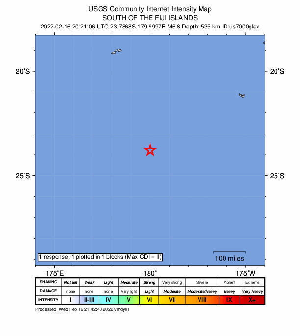
No tsunami threat to Hawaii following 6.8-magnitude earthquake south of Fiji

fiji
There is no tsunami threat to Hawaii following a 6.8-magnitude earthquake just south of Fiji. The earthquake occurred at 10:21 a.m. Hawaii standard time.

"A destructive Pacific-wide tsunami is not expected and there is no tsunami threat to Hawaii," according to a statement from the Pacific Tsunami Warning Center in Honolulu.

Seismograph

6.2 magnitude earthquake hits Guatemala

A car crushed by falling debris from a collapsing building in Guatemala's Totonicapán city
A major earthquake measuring 6.2 in magnitude has struck Guatemala reducing buildings to rubble.

The quake hit the Central American nation on Wednesday morning, with the epicentre in Nueva Concepción, the European Mediterranean Seismological Centre (EMSC) said.

It was at a depth of 96 km (60 miles), EMSC said.

The initial tremor was felt at 1.12am local time, before two aftershocks followed at 1.50am and 1.56am, measuring 5 and 4.8, according to reports.

An image of a car having been crushed by falling debris from a collapsing building was taken in Totonicapán city this morning.

While other snaps show rocks having fallen across a road and emergency workers digging through rubble.


Seismograph

'Invisible' earthquake caused mysterious 2021 tsunami, scientists find

2021 tsunami
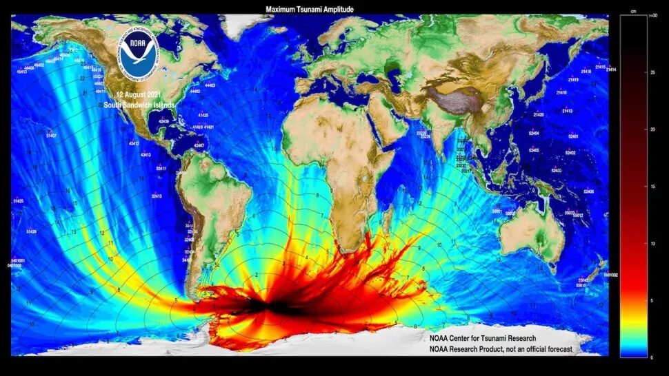
From its origin point in the South Atlantic, the 2021 tsunami sent ripples all over the world.
Some tsunami-generating earthquakes are invisible to our monitoring systems.

The mysterious source of a globe-spanning tsunami that spread as far as 6,000 miles (10,000 kilometers) from its epicenter was an "invisible" earthquake, a new study has found.

In August 2021, an enormous tsunami rippled out into the North Atlantic, Pacific and Indian oceans. It was the first time a tsunami had been recorded in three different oceans since the catastrophic 2004 Indian Ocean earthquake; at the time, scientists thought it was caused by a 7.5-magnitude earthquake detected near the South Sandwich Islands (a British Overseas Territory in the southern Atlantic Ocean).

But not everything was as it seemed. Scientists were baffled to find that the supposed epicenter of the earthquake was 30 miles (47 km) below the ocean floor, which is far too deep to cause a tsunami, and that the tectonic plate rupture that spawned it was nearly 250 miles (400 km) long — that kind of rupture should have caused a much larger earthquake.

Attention

9 earthquakes under Lake Erie already in 2022

Lake Erie
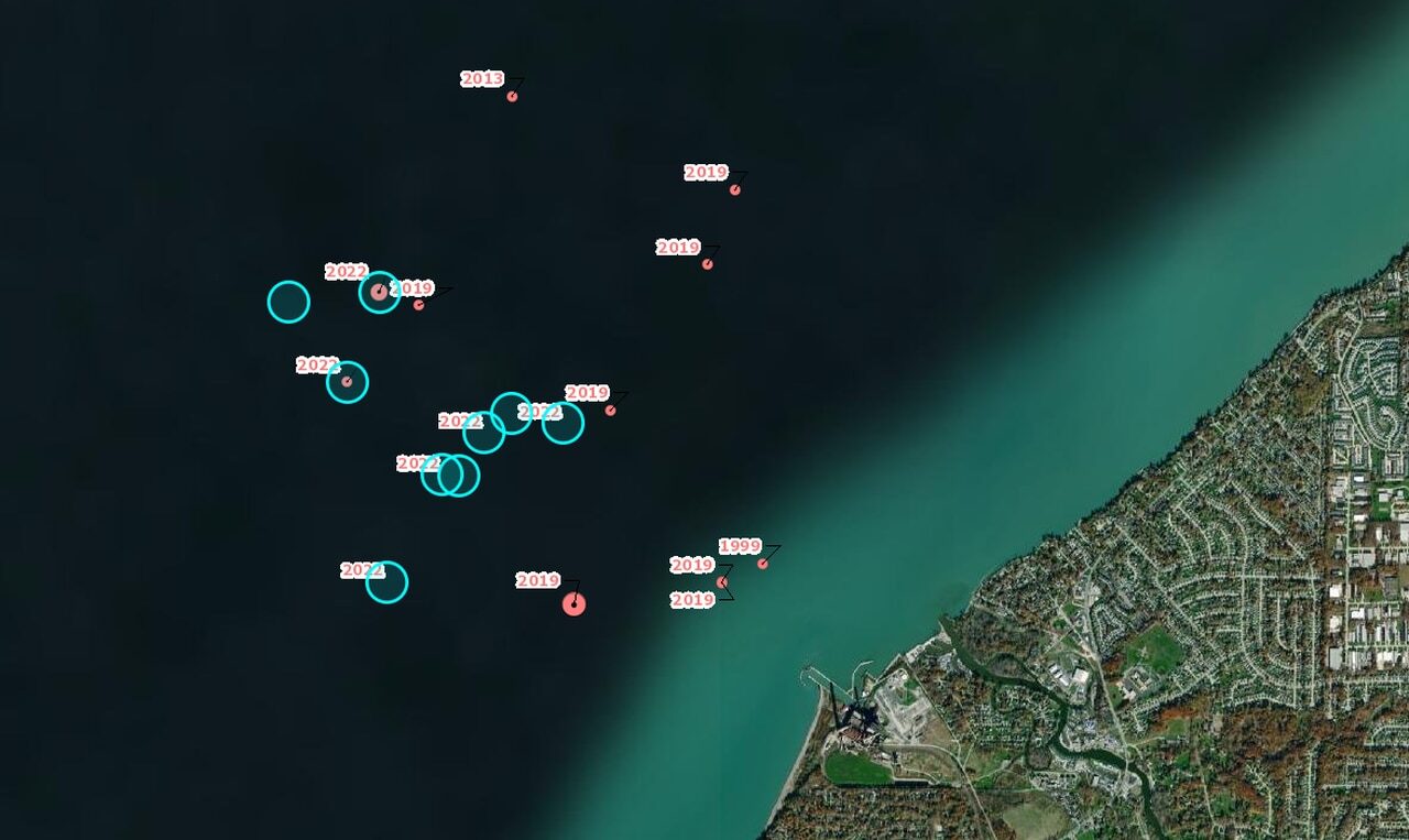
Nine small earthquakes have shaken Lake Erie off Lake County, Ohio, in the first six weeks of 2022, according to Ohio Department of Natural Resources seismic monitoring.

The Earth is trembling underneath Lake Erie.

Nine weak, shallow earthquakes have already struck central Lake Erie in the first weeks of 2022, according to the Ohio Department of Natural Resources, which, alongside the U.S. Geological Survey (USGS), tracks seismic activity in the region.

The quake epicenters are clustered about two miles offshore of Lake County east of Cleveland. They range from 1.3 to 3.0 in magnitude and some are being felt locally on shore. Quake depths range from 2.1 to 7.4 kilometers under the surface.

Comment: Notably, and possibly as a sign of an uptick in geologic activity in the region, a study of Lake Michigan published in March of 2021, using a 30-year data set of deep water measurements, found that deep water temperature there had been rising, and 'scientists don't know why'.

lake erie michigan
© GoogleRed pin shows location of Lake Erie, to the left is Lake Michigan
See also: And check out SOTT radio's:


Bizarro Earth

Hidden magnitude-8.2 earthquake source of mysterious 2021 global tsunami

Hidden Earthquake
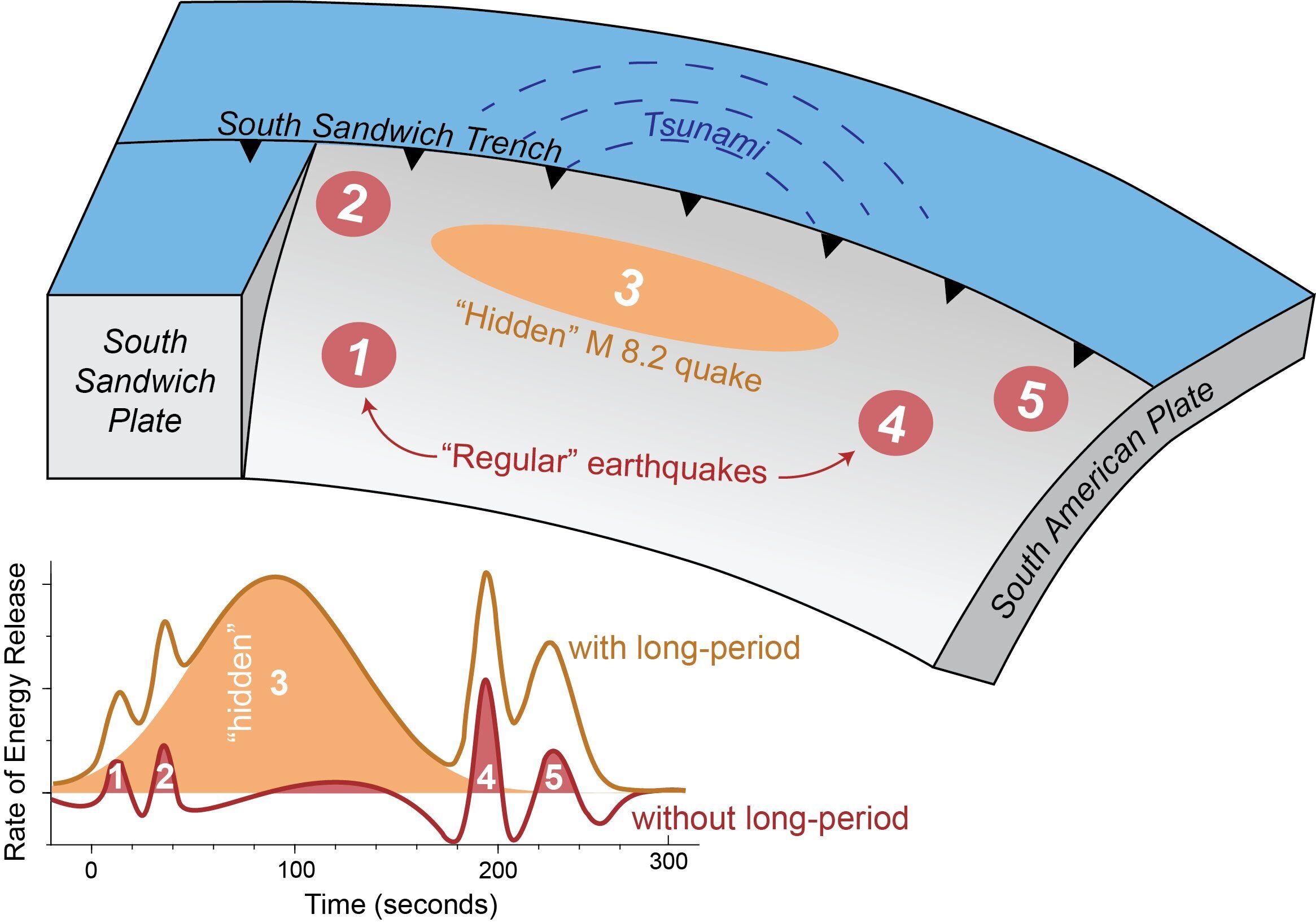
© Zhe Jia and AGUA magnitude 8.2 earthquake was “hidden” within a magnitude 7.5 earthquake in 2021, sending a mysterious tsunami around the world, according to a new study in Geophysical Research Letters.
Scientists have uncovered the source of a mysterious 2021 tsunami that sent waves around the globe.

In August 2021, a magnitude 7.5 earthquake hit near the South Sandwich Islands, creating a tsunami that rippled around the globe. The epicenter was 47 kilometers below the Earth's surface — too deep to initiate a tsunami — and the rupture was nearly 400 kilometers long, which should have generated a much larger earthquake.

Seismologists were puzzled and sought to understand what really happened that day in the remote South Atlantic.

A new study revealed the quake wasn't a single event, but five, a series of sub-quakes spread out over several minutes. The third sub-quake was a shallower, slower magnitude 8.2 quake that hit just 15 kilometers below the surface. That unusual, "hidden" earthquake was likely the trigger of the worldwide tsunami.

The study was published in the AGU journal Geophysical Research Letters, which publishes short-format, high-impact papers with implications that span the Earth and space sciences.

Because the South Sandwich Islands earthquake was complex, with multiple sub-quakes, its seismic signal was difficult to interpret, according to lead study author Zhe Jia, a seismologist at the California Institute of Technology. The magnitude 8.2 quake was hidden within the tangle of seismic waves, which interfered with each other over the course of the event. The hidden quake's signal wasn't clear until Jia filtered the waves using a much longer period, up to 500 seconds. Only then did the 200-second-long quake, which Jia said accounted for over 70% of the energy released during the earthquake, become clear.

"The third event is special because it was huge, and it was silent," Jia said. "In the data we normally look at [for earthquake monitoring], it was almost invisible."

Seismograph

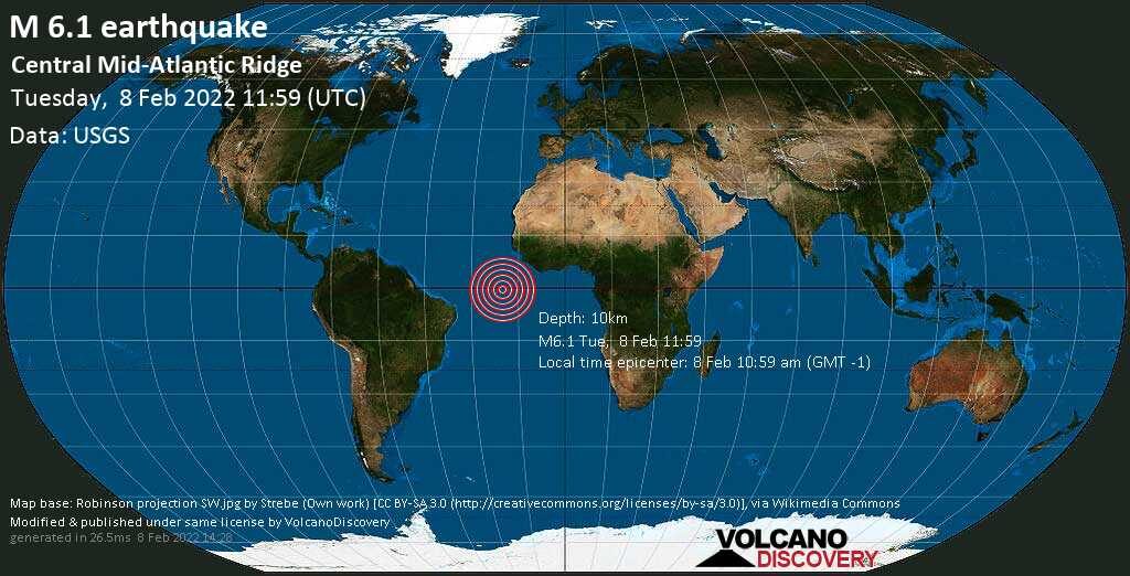
Shallow 6.2 magnitude earthquake at Mid-Atlantic Ridge

quake
6.2 magnitude earthquake

UTC time: Tuesday, February 08, 2022 11:59 AM
Your time: Tuesday, February 8, 2022, 11:59 AM GMT
Magnitude Type: mww
USGS page: M 6.2 - central Mid-Atlantic Ridge
USGS status: Reviewed by a seismologist
Reports from the public: 0 people

10 km depth