Earthquakes
S


Seismograph

6.4 magnitude earthquake shakes Philippines' main island

maps
A powerful earthquake struck off the Philippines' main island Monday, jolting buildings in the capital Manila, but there were no immediate reports of damage and a tsunami warning was not issued.

The shallow 6.4-magnitude quake hit about 110 kilometres (68 miles) off Morong in Bataan province on Luzon island at 5:05 am (2105 GMT), with residents in nearby Manila woken by their buildings shaking.

Shallow quakes tend to do more damage than deep tremors, but the Philippine Institute of Volcanology and Seismology said damage was not expected.

Comment: This significant quake struck within 5 minutes of another major one off West Sumatra, Indonesia.


Seismograph

Shallow 6.7-magnitude earthquake strikes off Indonesia's Sumatra

maps
A strong quake struck off the west coast of Indonesia's Sumatra island early on Monday (March 14), sending residents fleeing from their homes, but no damage or victims were reported immediately.

The shallow 6.7-magnitude earthquake hit at 2109 GMT (5:09am, Singapore time) at a depth of 21 kilometres (13 miles), with its epicentre 167 kilometres west of the coastal city of Pariaman, the United States Geological Survey (USGS) said.

The epicentre was 197 kilometres from Padang, the capital and largest city in West Sumatra province.


Comment: Just 4 minutes before this quake struck another of similar strength hit off the Phillipines.


Seismograph

6.1-magnitude earthquake hits Fiji region - USGS

maps
An earthquake with a magnitude of 6.1 jolted Fiji region at 05:34:18 GMT on Monday, the U.S. Geological Survey (USGS) said.

The epicenter, with a depth of 581.81 km, was initially determined to be at 20.3797 degrees south latitude and 178.4313 degrees west longitude.

Bizarro Earth

Geologists unravel plate tectonic chain reaction

A plate tectonic chain reaction.
© Utrecht UniversityA plate tectonic chain reaction.
Geologists at Utrecht University are working hard to unravel the secrets of plate tectonics, the mechanism that continuously shapes Earth's crust and is causing earthquakes and volcanic eruptions. This time, another mystery has been dissected. In the Earth's geological past, there were 'short' periods of a few million years during which many tectonic plates around the world suddenly changed their speed and direction. What caused these abrupt changes in plate movements? Earlier research showed that changes in movement between two plates can result from continental collisions or rising mantle plumes. But could such collisions or mantle plumes set off a global chain reaction? Now geologists have succeeded in finding evidence that supports this. "With this discovery, we are able to better understand the driving forces behind plate movements, and thus processes such as mountain formation or volcanism."

This paper, published in Nature Geoscience, was a collaboration between geoscientists from Utrecht University, Australian National University, and Ben-Gurion University of the Negev. To test their hypothesis, the researchers asked themselves the following question: did the formation of a new subduction zone north of Arabia that was triggered by a mantle plume that caused a super volcano near Madagascar ~100 million years ago set off a chain reaction? Utrecht professor of plate tectonics and paleogeography Douwe van Hinsbergen, geologist, former Utrecht PhD student and first author Derya Gürer, and geophysicist Roi Granot, analysed the consequences step by step. "If our hypothesis is correct, the new subduction zone that formed north of Arabia should have caused forces that accelerated, and rotated the African Plate in the 10 million years after subduction initiation. However, to analyse this, we had to solve a major problem," says Gürer.

Seismograph

Magnitude 6.6 earthquake strikes Kermadec Islands: USGS

graph
A magnitude-6.6 earthquake struck Kermadec Islands in New Zealand on Wednesday, according to the United States Geological Survey (USGS).

The epicenter was recorded at a depth of 36.2 kilometers.

Seismograph

Shallow magnitude 6.2 earthquake hits Indonesia's Sumatra island, killing at least 10 (UPDATE)

maps
At least two people have died and 20 people injured in West Pasaman regency in Indonesia, following a 6.2-magnitude earthquake on Friday (Feb 25) morning, National Disaster Management Agency (BNPB) chief Suharyanto said at a media briefing.

Some buildings, including a school and a bank in the Sumatra province, have also been damaged.

The agency is sending its quick response team to Pasaman and West Pasaman regencies, two most affected regions, Mr Suharyanto added.

The quake struck Sumatra island's north at a depth of 12km, about 70km from the town of Bukittinggi in West Sumatra province, the United States Geological Survey (USGS) said.

No tsunami warning was issued, but the quake was felt in the neighbouring provinces of Riau and North Sumatra, and as far away as Singapore and Malaysia.


Comment: Update:The York Press reports on February 27:
At least 10 dead in Indonesia earthquake as search continues

Search efforts were continuing on Sunday in the hardest-hit areas of Indonesia's Sumatra island after a strong earthquake killed 10 people, injured nearly 400 others and left thousands displaced, a disaster official said.

Rescuers retrieved two more bodies late on Saturday from the rubble of homes toppled by the magnitude 6.2 earthquake that shook West Sumatra province on Friday morning, said National Disaster Mitigation Agency spokesman Abdul Muhari.

Six people died in Pasaman district and four in neighboyring West Pasaman district, he said.

Rescuers were still searching for four villagers believed to be buried under tons of mud that tumbled down from the surrounding hills triggered by the quake.

At least 388 people were injured by the earthquake,
whose tremors were felt as far away as Malaysia and Singapore, and about 42 people were still receiving treatment for serious injuries, Mr Muhari said.

More than 13,000 people fled their homes to temporary shelters, mostly in devastated areas of Pasaman and West Pasaman districts, the closest areas to the epicentre as more than 1,400 houses and buildings were damaged, he said in a statement.

Indonesia, a vast archipelago of 270 million people, is frequently struck by earthquakes, volcanic eruptions and tsunamis because of its location on the Ring of Fire, an arc of volcanoes and fault lines across the Pacific.

The last major earthquake was in January 2021 when a magnitude 6.2 quake killed at least 105 people and injured nearly 6,500. More than 92,000 people were displaced after it struck Mamuju and Majene districts in West Sulawesi province.

A powerful Indian Ocean quake and tsunami in 2004 killed nearly 230,000 people in a dozen countries, most of them in Indonesia.

Info

Searching for earthquakes in the Ionosphere

Earthquake Damage
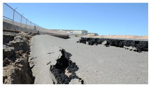
© Adam DuBrowa/FEMAA magnitude 7.2 earthquake damaged roads across northwestern Mexico and Southern California (like this one in Calexico) when it struck on 4 April 2010.
In 2010, at 40 minutes past 3:00 in the afternoon on 4 April — Easter Sunday — northwestern Mexico started to shake. A magnitude 7.2 earthquake was rattling the Baja California region, ultimately causing three deaths and more than 100 injuries. The quake caused widespread damage in the border cities of Mexicali, Mexico, and Calexico, Calif. The quake made skyscrapers sway in San Diego, more than 160 kilometers west.

The earthquake sent waves through the ground around it, but high in the atmosphere, a very different sort of perturbation might have offered a forewarning of the earthquake's impending arrival, had anyone been able to see it. Subtle fluctuations in Earth's ionosphere, a region of charged particles high above the surface, preceded the Baja earthquake, said the authors of a new paper published in Advances in Space Research. Somehow, the fault that caused the earthquake may have been telegraphing its impending rupture, sending out a rush of electrically charged particles that resonated in the ionosphere.

The ionosphere, which begins about 48 kilometers above Earth's surface and stretches to around 965 kilometers, is where incoming energy from the Sun ionizes molecules in the atmosphere, knocking off electrons. The abundance of charged particles means the ionosphere reacts to electric and magnetic fields, something other regions of the atmosphere generally do not do.

Using data from the Massachusetts Institute of Technology's Haystack Observatory on the density of electrons in the ionosphere, a team of Chinese and U.S. researchers analyzed the atmosphere above the Baja California region for 72 days both before and after the earthquake. After controlling for other things that might have been affecting the ionosphere, they said they saw a clear anomaly — a spike in the number of ionospheric electrons — on 25 March, 10 days before the earthquake. The electron spike was located over the earthquake's epicenter, and it didn't look like anything else they'd seen in the data.

We can imagine it to be something like ripples in a lake, said Chen Zhou, a researcher at Wuhan University in China and a coauthor of the paper. The electron signal looked like a brief, but telling, redistribution of particles from their normal movements and positions, one researchers were able to catch as it went by.

Zhou and his colleagues said their work could support a theory that faults release electrical energy in the days leading up to an earthquake. How exactly this happens isn't clear — some scientists think it's the result of radon gas released by a fault ionizing air molecules, whereas others hold that rocks under stress can release bursts of electrons.

Seismograph

Magnitude 6.0 earthquake hits Argentina

maps
A magnitude 6.0 earthquake struck Argentina on Tuesday.

No material damage or casualties have been reported so far.

The quake's epicenter was 58 kilometers (36 miles) west of Abra Pampa, a town in the northwestern Jujuy province, at a depth of 242 kilometers (150 miles), according to the US Geological Survey (USGS).

Seismograph

Strong shallow magnitude 6.3 earthquake near Balleny Islands off Antarctica

maps
Very strong magnitude 6.3 earthquake at 10 km depth

Date & time: Feb 21, 2022 23:24:12 UTC
Local time at epicenter: Tuesday, Feb 22, 2022 at 12:24 pm (GMT +13)
Magnitude: 6.3
Depth: 10.0 km
Epicenter latitude / longitude: 69.7601°S / 165.4321°E (South Pacific Ocean, Antarctica)

Bizarro Earth

Geologists map 9.0 magnitude quake's impact on the Cascadia subduction zone

CAscadia Subduction Zone
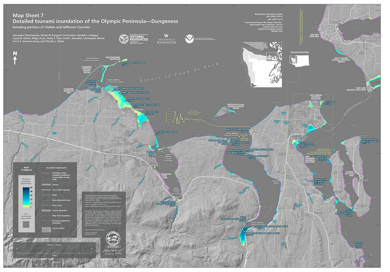
© Photo courtesy of Department of Natural ResourcesNew maps from the Department of Natural Resources show the potential flooding impact from a tsunami caused by a 9.0 earthquake along the Cascadia subduction zone.
New maps through a study by geologists with the Washington Geological Survey division of the Washington Department of Natural Resources show that a 9.0 magnitude earthquake could be devastating to the state's coastlines and roadways, including along the entirety of the Olympic Peninsula.

The new study, which became available days after the undersea volcanic eruption by Tonga on Jan. 15, uses a simulated magnitude 9.0 earthquake on the Cascadia subduction zone, according to DNR staff.

Geologists predict the first tsunami waves could reach La Push 10 minutes from the start of the earthquake, and Washington's Pacific coast in about 30 minutes.

Port Angeles would see waves about an hour from the earthquake's start, Dungeness at about 80 minutes, Miller Peninsula about 85 minutes, Blyn 90 minutes and Discovery Bay about 95 minutes.

Along the Pacific coast, flooding could reach or exceed 60 feet, geologists predict, and 100 feet at Yellow Banks Beach in Olympic National Park.

The Sequim area could see inundation of about 10 feet in Dungeness, 7 feet in Port Williams County Park, and portions of Gardiner and the Miller Peninsula, 6 feet at Washington Harbor, and 5 feet in Blyn.

Discovery Bay has the largest potential for flooding at a predicted 33 feet, which would likely block and/or destroy portions of U.S. Highway 101 and State Route 112.

Commissioner of Public Lands Hilary Franz said via press release that the "report shows what we've long known — there won't be time for our coastal communities to react after a major earthquake, so it's vital we provide these detailed models and keep our communities safe when, not if, the next Cascadia mega-quake hits."

DNR staff said the last Cascadia rupture occurred 321 years ago, and experts estimate a 10-17 percent chance of a rupture in the next 50 years.

Geologists' model does not include tide stages or local tsunamis triggered by earthquake-induced landslides.