While extreme Arctic conditions have spared southern Canada of late, instead favoring to dip deep into Asia where Russia and even the subtropical regions of China and India continue to suffer record-breaking sub-zero temperatures, things have played out very differently in northern Canada.
Taking Kugaaruk as an example, on the morning of Tuesday, January 5 the small Nunavut hamlet located on the shore of Pelly Bay registered -47C (-52.6F) — this was a temperature among the area's coldest on record, and it also comfortably broke the previous Jan. 5 all-time low of -42C (-43.6F) set back in 1985 (solar minimum of cycle 21).
In addition to the official new record low, a staggering windchill or "feels-like" benchmark was also set.
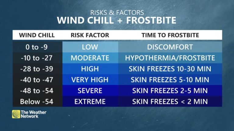
When speaking to Yahoo News, Jaclyn Whittal, meteorologist at the Weather Network, pointed out that Kugaaruk's windchill was over -60C (-76F) early Tuesday morning, a number she said is hard to even wrap your head around.
"Windchills of minus 60 would freeze your skin in less than two minutes," said Whittal. "Think about that. It takes two minutes to order a coffee at a drive-through".
Extreme windchills have also buffeted the Nunavut communities of Shepherd Bay and Taloyoak in recent days, with both registering lows of -62C (-79.CF):
Kugaaruk's intense cold continued into the early hours of Wednesday, too.
According to the Weather Network data, the temperature at 4AM local time stood at -46C (-50.8F) with a reported windchill of -56C (68.8F).
And as mentioned above, while northern Canada has been unusually cold of late, southern regions have been usually mild-but all that looks set to change as we enter the second half of January: latest GFS runs show an expansive mass of polar cold breaking free from the Arctic beginning Jan. 15 and sinking as far south as Florida in the U.S. by Jan. 17/18.
Stay tuned for updates.
The COLD TIMES are returning, the mid-latitudes are REFREEZING in line with the great conjunction, historically low solar activity, cloud-nucleating Cosmic Rays, and a meridional jet stream flow (among other forcings).
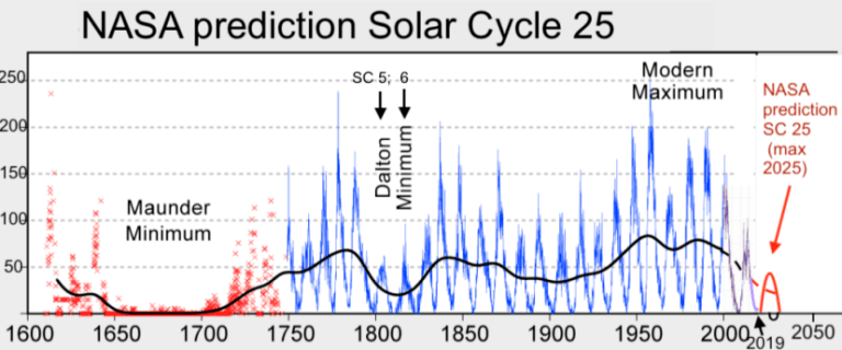
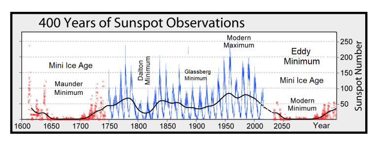
Both NOAA and NASA appear to agree, if you read between the lines, with NOAA saying we're entering a 'full-blown' Grand Solar Minimum in the late-2020s, and NASA seeing this upcoming solar cycle (25) as "the weakest of the past 200 years", with the agency correlating previous solar shutdowns to prolonged periods of global cooling here.
Furthermore, we can't ignore the slew of new scientific papers stating the immense impact The Beaufort Gyre could have on the Gulf Stream, and therefore the climate overall.
Prepare accordingly — learn the facts, relocate if need be, and grow your own.
Social Media channels are restricting Electroverse's reach: Twitter are purging followers while Facebook are labeling posts as "false" and have slapped-on crippling page restrictions.
Be sure to subscribe to receive new post notifications by email (the box is located in the sidebar >>> or scroll down if on mobile).
And/or become a Patron, by clicking here: patreon.com/join/electroverse, and/or consider "allowing ads" for www.electroverse.net if you use a blocker.
The site receives ZERO funding, and never has. So any way you can, help us spread the message so others can survive and thrive in the coming times.


Comment: Global temp plunges 0.26C in a month: "The next ice age has just started"