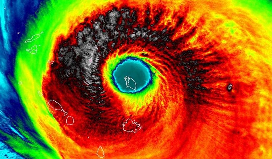
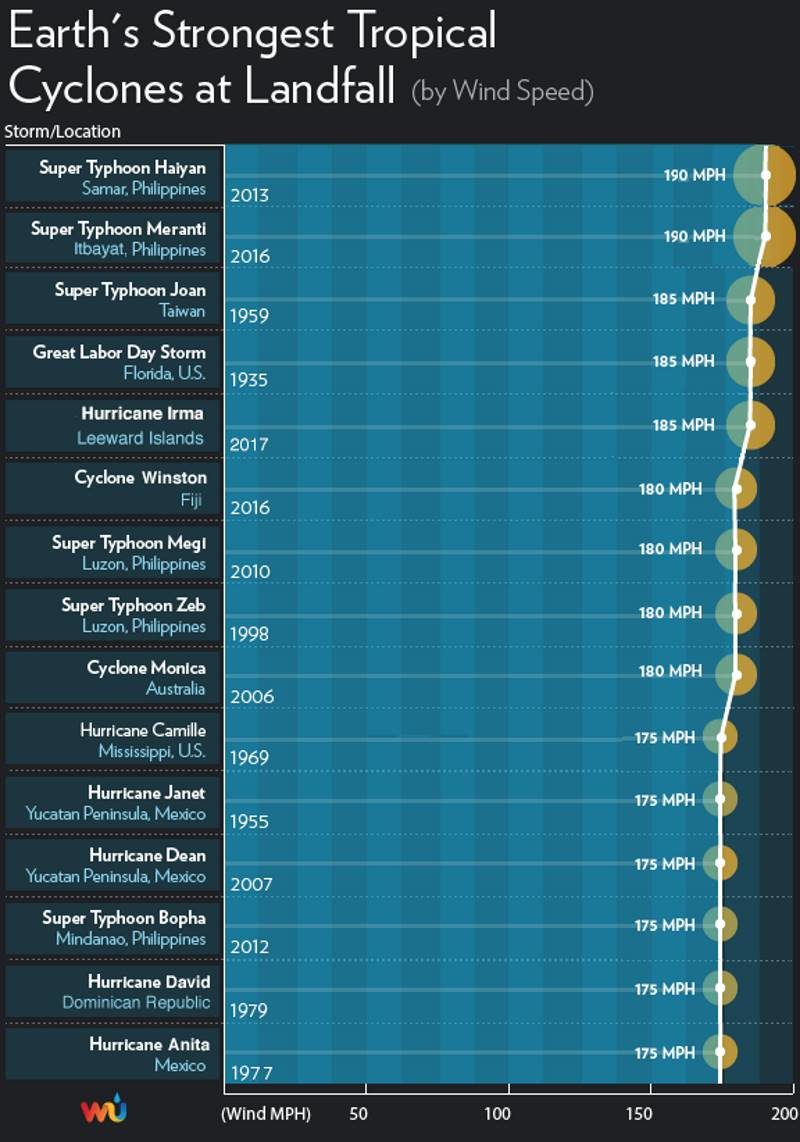
A hurricane with top winds of 185 mph has never been recorded in these islands, and Irma's landfall intensity of 185 mph winds in the Leeward islands is tied with the 1935 Florida Keys Labor Day Hurricane as the highest landfall intensity on record for an Atlantic hurricane (third place globally.) The most recent close analog for Irma may be Hurricane Hugo (1989), which tore through the Leewards and struck Puerto Rico as a Category 4 storm, causing $3 billion in damage (1989 dollars) and 72 deaths.
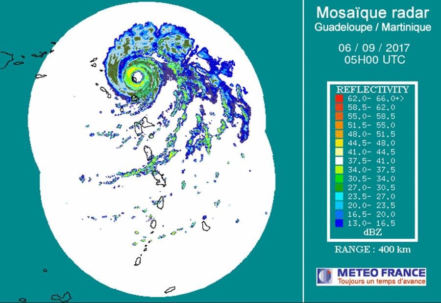
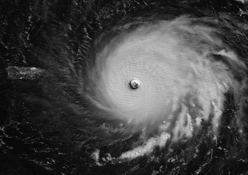
Next targets: British Virgin Islands, U.S. Virgin Islands, and Puerto Rico
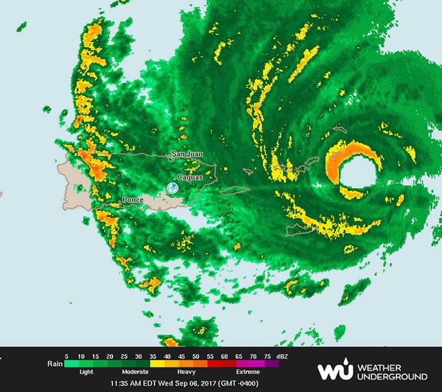
On Wednesday afternoon, Irma will make a direct hit on the British Virgin Islands, including Virgin Gorda (population 4,000), and Tortola (population 9,000.) The southern eyewall of Irma is also likely to affect the island of Saint John (population 4,000) in the U.S. Virgin Islands. A personal weather station on the south shore of St. Thomas measured sustained winds of 94 mph at 12:33 pm Wednesday. The island of Saint Thomas (population 52,000) may barely miss the eyewall of Irma, but northeastern portions of the island are still likely to receive sustained Category 1 hurricane winds of 75 - 90 mph. The same holds true for Puerto Rico's Culebra Island. The extreme northeast corner of Puerto Rico should see slightly lower winds, near 60 - 80 mph.
Longer-range outlook for Irma: Cuba, the Bahamas, and Southeast U.S.
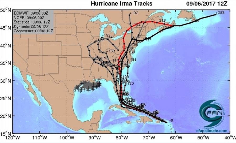
Computer model guidance has begun to consolidate somewhat on Irma's future during the period from Saturday onward, but there remains major uncertainty on exactly where Irma will track. Our top three track models-the European, GFS, and UKMET models-continue to agree strongly that Irma will continue on a west-northwest track through at least Friday. NHC predicts that Irma will still be a Category 5 hurricane through at least Friday morning. By late Thursday, Irma will likely be in or near the Southeast Bahamas, which are under a Hurricane Warning, with a Hurricane Watch for the Central Bahamas as of Wednesday morning. Some of the islands of the Southeast Bahamas may take a direct hit from Irma, and other islands may wind up in the dangerous right-hand side of the storm. Irma has the potential to be a devastating storm for The Bahamas, especially its southern islands, and residents should rush any needed preparations to completion.
By Saturday, there is fairly strong model agreement that Irma will be located somewhere between the western Bahamas and Cuba, still on its west-northwest track. Irma will be paralleling the north coast of Cuba, and it is possible Irma's center will move just inland along the coast for some period of time; parts of the north coast of Cuba are within the "cone of uncertainty" in the official NHC forecast. Residents of Cuba will need to pay very close attention to Irma's track. The eastern two-thirds of Cuba was under a Hurricane Watch as of Wednesday morning. Irma is not expected to cross Cuba and move into the Caribbean.
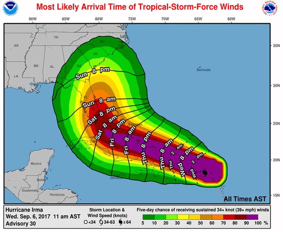
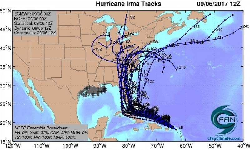
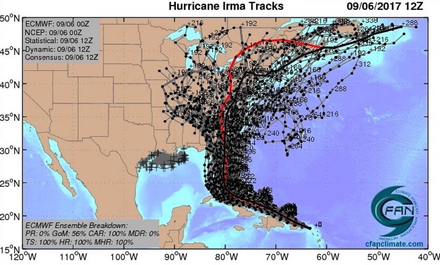
In short, computer guidance is in strong agreement that Irma will make at least one landfall somewhere from Florida to North Carolina during the weekend or early next week. The official NHC forecast track as of 11 am Wednesday brings Irma from near Miami to near Daytona Beach from Sunday morning to Monday morning. The 12Z Tuesday run of the GFS model predicts that Irma will hit Miami on Sunday afternoon, then make a second landfall near the Georgia/South Carolina border on Monday afternoon, with both landfalls occurring with at least Category 4 strength.
The entire Florida peninsula and southeast Georgia are within the five-day cone of uncertainty in the official NHC forecast, and all residents of these areas should pay especially close attention to the progress of Irma. Residents of southeast Florida need to be especially vigilant.
Intensity and storm surge
By the time of its turn, Irma is still predicted to be a Category 4 hurricane by NHC, and the GFS and European forecast models imply that Irma could be close to Category 5 strength, especially if its center does not move onshore across northern Cuba. Wind shear is predicted to remain low to moderate along Irma's path until Saturday, and Irma will be passing over waters that are as warm or slightly warmer than its current environment, so there is nothing that would be expected to cause major weakening of Irma other than potential land interactions, especially with Cuba. As Irma moves northward, increasing wind shear and interactions with land will likely begin to weaken Irma. However, Irma is expected to remain a major hurricane well after its northward turn, even if its center moves over the Florida peninsula and especially if the center remains just off the coast. The official NHC forecast as of 11 am Wednesday has Irma as a Category 3 storm on the east-central Florida coast on Monday morning.
Because of Irma's long life and its extreme strength, Irma will be pushing a tremendous amount of water through the Bahamas in the form of high waves and storm surge. Even if Irma's winds weaken and its Saffir-Simpson category drops, Irma could still be capable of extreme storm surge, depending on its track and the geography of its landfall location(s). Storm surge expert Dr. Hal Needham noted in a blog post Wednesday: "The region from northeast Florida (St. Augustine) through all of the Georgia coast and southwest South Carolina is particularly vulnerable to storm surge, whether or not Irma makes a direct landfall in that region."
Meanwhile, we have Jose and Katia
Two other tropical storms have developed since Tuesday morning. Tropical Storm Jose bolted to near-hurricane strength overnight, with top sustained winds of 70 mph as of 11 am Wednesday. Located about 1100 miles east of the Lesser Antilles, Jose is headed at 17 mph on a steady west-northwest track, steered by the same ridge that is helping to direct Irma. On its current track, Jose would reach the northern Leeward Islands by Saturday, but the ridge is predicted to weaken enough by Saturday to allow Jose to arc just northeast of the islands. Conditions are favorable for Jose to strengthen into a hurricane by later Wednesday, and it could approach Category 3 strength by late in the week. About 25% of the European model ensemble members bring Jose into the northern Leeward Islands, but all of the GFS ensemble members keep Jose north of the islands.
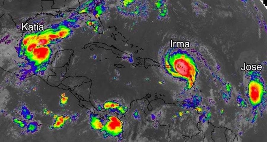
Tropical Storm Katia was christened by NHC at 5 am EDT Wednesday, and its estimated top winds had increased to 45 mph as of 11 am EDT. Located in the Bay of Campeche about 175 miles north of Veracruz, Mexico, Katia is embedded in a very moist environment with numerous showers and thunderstorms along and south of a frontal zone (see Figure 9), and the storm's core has become gradually more organized. NHC predicts that Katia will become a hurricane by Friday atop the bay's very warm waters (30-31°C or 86-88°F). Wind shear will be dropping from about 10-15 knots to around 5-10 knots by Friday, which also supports development. Our top track models and the Euro and GFS ensembles are unanimous in drifting Katia for a couple of days before driving it southwestward into the Mexican coast this weekend. Extremely heavy rains of 10 - 20" are possible along parts of the northeast Mexican coast, especially in northern Veracruz, as Katia approaches and moves inland.


Reader Comments
to our Newsletter