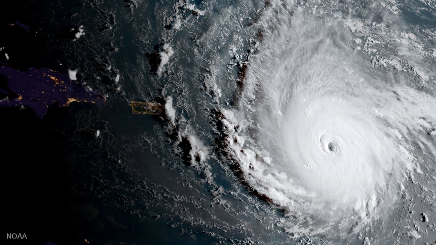
That's just one shattering measure of the storm's strength from meteorologist Phil Klotzbach, research scientist at Colorado State University's Department of Atmospheric Science. Irma's 185 mph winds make it the strongest storm on record in the Atlantic Ocean outside of the Caribbean and Gulf of Mexico, according to Klotzbach's research, which he shared with The Daily Beast.
"Most of the other storms this season were pretty weak and short-lived. While Harvey was intense, it was intense for a short time period before making landfall," Klotzbach said.
Irma's wind speeds are tied with the second-strongest maximum winds of all time for an Atlantic hurricane, matching a 1935 storm in the Florida Keys and Hurricanes Gilbert (1988) and Wilma (2005). Only one hurricane, Allen in 1980, has recorded stronger winds, at 190 mph. Irma has broken Allen's record for sustained winds though.
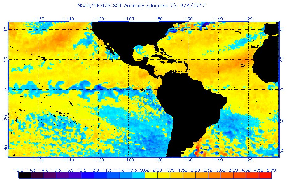
The intense winds make Irma a Category 5 storm, the most severe on the hurricane scale. Hurricane Harvey, which flooded Houston and destroyed swaths of Texas, was a Category 4.Irma grew so powerful so quickly to due to a combination of very warm water, high levels of mid-level relative humidity, and vertical wind condition.
"A hurricane's primary fuel source is warm ocean water, so warmer water provides more fuel for the storm," Klotzbach said. "Anomalously high mid-level relative humidity provides the moisture necessary for thunderstorm formation, which are the building blocks of hurricanes."The tropical Atlantic, stretching from the west coast of Africa (where hurricanes form) to the Caribbean, has been warmer in recent years, but Klotzbach said it's "too early to say conclusively that it's climate-change related."
Irma destroyed 90 percent of the Caribbean island of Barbuda, the prime minister of Antigua and Barbuda said Wednesday night. Barbuda is home to about 1,600 residents.
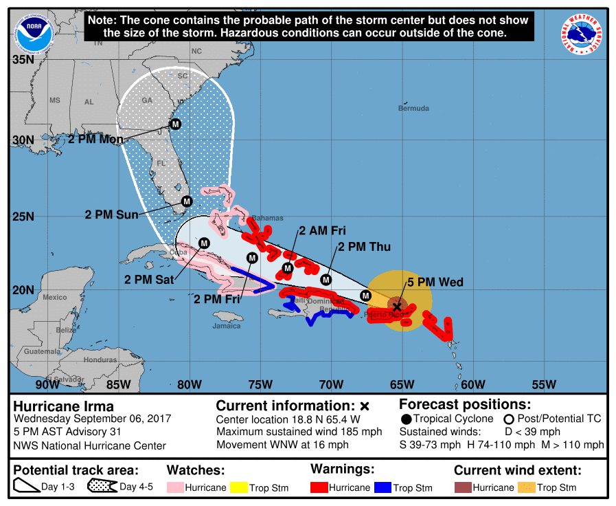
The National Weather Service forecasts Irma's "extremely dangerous core" to pass just north of Puerto Rico on Wednesday night, pass near or just north of the coast of the Dominican Republic and Haiti on Thursday, and reach the Turks and Caicos and southeastern Bahamas by Thursday evening.
Irma's final destination appears to be Florida, with its 20 million residents. The National Hurricane Center forecasts tropical-storm force winds beginning to buffet the state on Sunday night with hurricane-force winds expected Monday.
"There was also a fairly marked shift in the forecast track guidance and now puts the highest threat along the east coast of Florida or potentially into the Carolinas," Klotzbach said. "NHC has responded by shifting their track somewhat further east but not as far as some of the models have shifted. It still remains to be seen if this forecast track shift is going to continue, however."
The National Hurricane Center projects Irma will make landfall as a Category 4 storm, which would be the strongest storm to hit Florida since Charlie in 2004. No Category 5 storm has hit Florida since 1992's Andrew, which killed 62 people.
The powerful winds of Category 4 and 5 storms are capable of destroying framed homes and snapping trees, according to the National Hurricane Center. "Fallen trees and power poles will isolate residential areas. Power outages will last for weeks to possibly months," NHC warns. "Most of the area will be uninhabitable for weeks or months."
Officials ordered mandatory evacuations in the Florida Keys and Broward County, north of Miami, on Wednesday. Miami-Dade County has not ordered evacuations yet, though the mayor warned people in low-lying areas and islands may need to leave.
"The storm's slowing down, giving us a little bit more time," Mayor Carlos Gimene said.
Already though two Category 2 hurricanes have formed in the hemisphere: Katia in the Gulf of Mexico, expected to hit Mexico, and Jose in the Atlantic.


Reader Comments
to our Newsletter