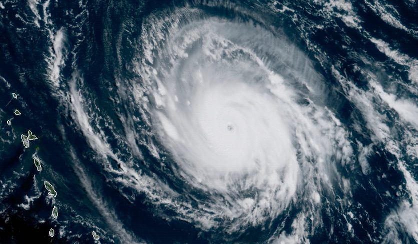
© RAMMB / CIRA @ CSU
Irma spun into a monster storm Tuesday morning with sustained winds topping 180 mph, becoming the strongest Atlantic hurricane ever recorded outside the Gulf of Mexico and Caribbean,
National Hurricane Center forecasters said in their 11 a.m. advisory.
As the hurricane churns closer to the U.S. coast, its path becomes more certain, with South Florida, particularly the Keys, increasingly likely to take a hit. Tropical storm force winds could arrive as early as Friday. Gov. Rick Scott has declared a state of emergency for all 67 counties and has all 7,000 members of the state's National Guard to report to duty on Friday.
UPDATE: Irma's winds have intensified. To read the latest, see
http://www.miamiherald.com/news/weather/hurricane/article171330777.htmlBecause Irma is so large, forecasters urged caution in paying too much attention to its exact track. The storm is continuing to roll west at 14 mph, with winds expected to begin battering the Leeward Islands today. A powerful high pressure ridge is steering the storm and will likely stay in place over the next few days, forecasters said. In five days, a trough moving across the U.S. should begin weakening the western edge of the ridge, allowing the storm to slide north. Where Irma makes the turn will determine impacts to Florida.
Monroe County announced that it will begin issuing mandatory evacuation orders for visitors at sunrise Wednesday. Residents will also be ordered to leave, although no time has yet been determined, county officials said. Schools and county offices will also be closed, beginning Wednesday.
"If ever there was a storm to take seriously in the Keys, this is it," Monroe County Emergency Management Director Martin Senterfitt said. "The sooner people leave, the better."
Dangerous conditions, with hurricane force winds, are expected to hit the Leeward Islands tonight and Virgin Islands and Puerto Rico on Wednesday. Fierce hurricane winds extend 60 miles from Irma's center, with tropical storm force winds reaching another 160 miles.Hurricane watches have also been issued for portions of the Dominican Republic and Haiti, the southeastern Bahamas and Turks and Caicos, with fierce winds, storm surge and heavy rain Thursday and Friday. In Puerto Rico, the governor has declared a state of emergency and is preparing to open 456 shelters that can house more than 62,000. Puerto Rico's power company also warned that Irma could cut off the island's electricity for four to six months.
Irma could strike a direct blow on the remainder of the Bahamas and Cuba later in the week, they said. The likelihood of Irma hitting the Keys or parts of South Florida is also increasing, however forecasters warned it's too soon to determine what impacts the region might feel.At 11 a.m., Irma was located 225 miles east of Antigua, heading west at 14 mph. While wind speeds could fluctuate over the next day or two, forecasters say it will likely remain a very dangerous Cat 4 or 5 storm as it heads westward.
Scott also said he spoke to President Donald Trump Monday to request a federal state of emergency in advance of Irma's arrival.
"This morning, I am requesting the president declare a pre-landfall emergency for the State of Florida to help preposition necessary resources and support emergency protective measures across the state," he said. "It is crucial that we have access to every available resource to protect our families and communities."
Across the mainland, the South Florida Water Management District has already begun inspecting pumps and gates and lowering canals to make room for heavy rain, flushing as much water as possible starting in South Dade. In a morning press conference, Chief Engineer John Mitnik said he expects the storm to dump between eight and 10 inches of rain, but where it falls depends on Irma's track.
Unlike Harvey, Irma is not forecast to linger and deliver the kind of punishing rain that triggered widespread flooding and likely billions of dollars in damage. Mitnik said South Florida's extensive system of canals are also capable of moving water quickly, however local drainage depends on flood controls set up in neighborhoods and subdivisions."If your particular subdivision was designed to have street flooding, then that's what you'll expect to see," he said.
Timing is another issue.
"If you take eight to 10 inches over several days, or compact it in 30 minutes, those are two different things," he said.
The U.S. Army Corps of Engineers is also keeping a close eye on the aging dike around Lake Okeechobee, where water levels Tuesday were at 13.65 feet, still well below the 15.5 feet level where discharges begin and the more than 18 feet limit set to protect the dike.
While models have shifted Irma's path up and down over the weekend, Tuesday morning's runs largely agree on the storm's path over the next three days, with less certainty after that.
Over the last week, Irma has also undergone repeated eyewall replacements, a common structural change for such massive storms. While the replacement may initially weaken the storm, it allows it to spread and grow in size. With each replacement, Irma has also been able to regain steam.
Reader Comments