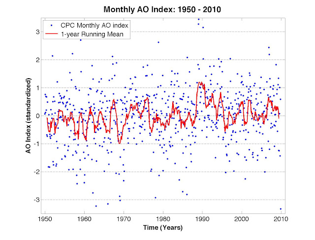
A big driver of the outbreaks of record cold and snow in many spots around the Northern Hemisphere is the little blue dot at the lower right-hand corner of the graph above, just above the year 2010. The chart (generated by Ignatius Rigor for Dot Earth) shows the state of the Arctic Oscillation, a pattern of atmospheric pressure that has two phases, positive and negative (somewhat like the more familiar cycle of El Niño and La Niña in the Pacific). A strong negative or positive condition can powerfully influence weather around the northern half of the globe and the behavior of sea ice on the Arctic Ocean.
The blue dot shows an extraordinary negative plunge of the index in December, taking it below any such reading since at least 1950. (I ran a preliminary version of the chart in a recent post on sea ice trends, but now it's been updated with the full month's readings of atmospheric pressures.)
The contribution of this pattern to current weather hasn't been highlighted much by most of those drawing attention to the chilly conditions of late, though. Instead, " Availability entrepreneurs" appear to be out in force, extracting all kinds of meanings or inferences from the frigid conditions. The head of the Beijing Meteorological Bureau asserted that global warming was behind unusual atmospheric patterns (a heap of climate scientists I queried saw no such link). Blogs of those variously called climate realists/skeptics/deniers are hammering on the chilly conditions, presumably in hopes of fending off a new push to close out the climate bill in the Senate.
John Michael Wallace of the University of Washington, one of the climate scientists who first identified the seesaw patterns of pressure around the North Pole and northern mid-latitudes, told me that the steep drop at the moment is likely to be transitory rather than a sign of a new trend in the Northern Hemisphere pressure cycle.
Overall, federal forecasters have said that the warming influence of a persistent El Niño warming of the tropical Pacific Ocean is likely to be a bigger driver of conditions through the full course of this winter. When it's freezing where you sit, it's hard to keep in mind that it may be extraordinarily warm elsewhere, as Joe Romm pointed out today.
Michelle L'Heureux, a meteorologist at the National Oceanic and Atmospheric Administration's Climate Prediction Center, told me there's simply no explanation for what drives such extremes in the Arctic Oscillation, which she described as both a potent driver of northern latitude conditions and one of the least predictable, and understood, patterns in the atmosphere.
Here's the earlier post that explains the relationship between the negative phase of the Arctic Oscillation and cold conditions over North America and western Europe - as well as sea ice on the Arctic Ocean:


Reader Comments
to our Newsletter