|
| ©COLLEEN WHITE / WATERTOWN DAILY TIMES
|
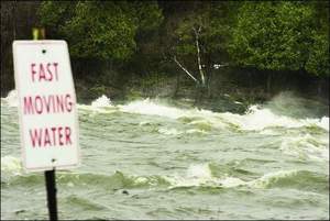
| The Black River is running high and fast, as seen from the fishing access point in Glen Park Friday. The U.S. Geological Survey has issued a flood watch through Sunday.
|
Less than four inches from cresting its banks, the Black River is expected to exceed its 10-foot flood stage tonight or early Sunday morning.
"Those living near the Black River should be prepared to take action should flooding develop," a U.S. Geological Survey release circulated Friday states.
The National Weather Service has posted flood warnings for low-lying areas in Jefferson and Lewis counties until Sunday afternoon.
In Lewis County, East Martinsburg Road in the town of Watson was closed Friday afternoon due to flooding, a common occurrence during spring runoff. It has been closed since April 2.
Another road that frequently closes due to flooding - Ridge Road in the towns of Denmark and Lowville - on Friday evening was marked with "Road Flooded" signs. However, no water had actually reached the pavement.
No roads were closed Friday night in Jefferson County, a county dispatcher said.
Authorities at the Hudson River-Black River Regulating District are blaming lingering snow, warm temperatures and steady rains for the expected flooding.
The river was flowing at 22,700 cubic feet per second through Watertown, according to the regulating district Web site. Historical averages for the river this time of year are about 10,000 cfs.
"Due to the cold late winter and early spring weather, much of the snow in the higher elevations did not melt and run off sooner," said Glenn A. LaFave, regulating district executive director, in a press release. "The earlier above-normal precipitation and water content in the snow, combined with current warmer temperatures and rain, is now contributing to the excessive runoff."
The regulating district releases water from the Stillwater Reservoir into the Black River to keep the river at a minimum of 1,000 cfs during dry spells.
Water was still being released from the Herkimer County reservoir Friday night.
The district is now deciding whether to release more water and allow the river to flood or to hold water back and allow the reservoir to fill faster, possibly allowing water to flow freely over the top of the dam if the rain continues, regulating district Chief Engineer Robert S. Foltan said.
The reservoir was at a height of 1,676.3 feet above sea level Friday night and is expected to reach the dam's peak at 1,679.3 feet this weekend.
Water was flowing into the reservoir at 2,300 cubic feet per second Friday afternoon while only 670 cfs was being released from the dam, Mr. Foltan said.
Depending on the amount of rain that falls in Herkimer County, water is expected to exceed the dam's flashboards early next week.
"There are a lot of variables were monitoring," Mr. Foltan said.
The National Weather Service is predicting rain mixed with snow until Monday night.
"We're taking a paced approach to this right now," he said.
In Lewis County, officials aren't overly concerned yet. If the weather forecast proves accurate, the situation shouldn't get a lot worse over the weekend, county Emergency Management Director James M. Martin said.
"We should get through this episode without too much of a problem - hopefully," he said.
While melting snow from the Tug Hill Plateau raised water levels in the Black River, the slow and steady rain on Friday didn't seem to have much of an impact, Mr. Martin said. And relatively low temperatures over the next couple days should slow the snow melt, giving the water time to recede, he said.
"We'll watch it day by day," Mr. Martin said.
Staff Reporter Steve Virkler contributed to this article.
Reader Comments
to our Newsletter