The Colorado State University forecast team upgraded its early season forecast today from the Bahamas Weather Conference, saying the U.S. Atlantic basin will likely experience a well above-average hurricane season.
"Current oceanic and atmospheric trends indicate that we will likely have an active Atlantic basin hurricane season," said William Gray, who is beginning his 25th year forecasting hurricanes at Colorado State University.

|
| ©NOAA
|
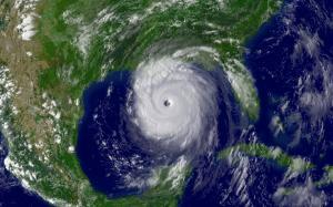
| Hurricane Katrina. The Colorado State University team's forecast now anticipates 15 named storms forming in the Atlantic basin between June 1 and Nov. 30. Eight of the storms are predicted to become hurricanes, and of those eight, four are expected to develop into intense or major hurricanes.
|
The team's forecast now anticipates 15 named storms forming in the Atlantic basin between June 1 and Nov. 30. Eight of the storms are predicted to become hurricanes, and of those eight, four are expected to develop into intense or major hurricanes (Saffir/Simpson category 3-4-5) with sustained winds of 111 mph or greater. Long-term averages are 9.6 named storms, 5.9 hurricanes and 2.3 intense hurricanes per year.
"Based on our latest forecast, the probability of a major hurricane making landfall along the U.S. coastline is 69 percent compared with the last-century average of 52 percent," said Phil Klotzbach of the Colorado State hurricane forecast team. "We are calling for a very active hurricane season this year, but not as active as the 2004 and 2005 seasons."
Current conditions in the Atlantic basin are quite favorable for an active hurricane season. The current sea surface temperature pattern in the Atlantic - prevalent in most years since 1995 - is a pattern typically observed before very active seasons. Warm sea surface temperatures are likely to continue being present in the tropical and North Atlantic during 2008 because of a positive phase of the Atlantic Multidecadal Oscillation (AMO). Also, the currently observed weak Azores High will likely promote weaker-than-normal trade winds over the next few months enhancing warm SST anomalies in the tropical and subtropical Atlantic.
Additionally, the team expects neutral or weak La Nina conditions in the tropical Pacific, which, combined with a predicted warm north and tropical Atlantic, is a recipe for enhanced Atlantic basin hurricane activity. These factors are similar to conditions that occurred during the 1950, 1989, 1999, and 2000 seasons. The average of these four seasons had well above-average activity, and Klotzbach and Gray predict the 2008 season will have activity in line with the average of these four years.
The hurricane forecast team predicts tropical cyclone activity in 2008 will be 160 percent of the average season. By comparison, 2005 witnessed tropical cyclone activity that was about 275 percent of the average season.
The hurricane forecast team reiterated its probabilities for a major hurricane making landfall on U.S. soil:
A 69 percent chance that at least one major hurricane will make landfall on the U.S. coastline in 2008 (the long-term average probability is 52 percent).
A 45 percent chance that a major hurricane will make landfall on the U.S. East Coast, including the Florida Peninsula (the long-term average is 31 percent)
A 44 percent chance that a major hurricane will make landfall on the Gulf Coast from the Florida Panhandle west to Brownsville (the long-term average is 30 percent).
The team also predicted above-average major hurricane landfall risk in the Caribbean.
"The United States was quite fortunate over the last two years in that we had only one hurricane landfall (
Humberto - 2007)," Klotzbach said. "None of the four major hurricanes that formed in 2006 and 2007 made U.S. landfall."
The Colorado State hurricane forecast team has cautioned against reading too much into the hurricane seasons of 2004 and 2005 when Florida and the Gulf Coast were ravaged by four landfalling hurricanes each year. Hurricanes Charley, Frances, Ivan and Jeanne caused devastating damage in 2004 followed by Dennis, Katrina, Rita and Wilma in 2005.
"The activity of these two years was unusual, but within the natural bounds of hurricane variation," Gray said.
Probabilities of tropical storm-force, hurricane-force and intense hurricane-force winds occurring at specific locations along the U.S. East and Gulf Coasts within a variety of time periods are listed on the forecast team's Landfall Probability Web site. The site provides U.S. landfall probabilities for 11 regions, 55 sub-regions and 205 individual counties along the U.S. coastline from Brownsville, Texas, to Eastport, Maine. The Web site, available to the public
HERE, is the first publicly accessible Internet tool that adjusts landfall probabilities for regions, sub-regions and counties based on the current climate and its projected effects on the upcoming hurricane season. Klotzbach and Gray update the site regularly with assistance from the GeoGraphics Laboratory at Bridgewater State College in Massachusetts.
The hurricane team's forecasts are based on the premise that global oceanic and atmospheric conditions - such as El Nino, sea surface temperatures and sea level pressures - that preceded active or inactive hurricane seasons in the past provide meaningful information about similar trends in future seasons.
The team will issue seasonal updates of its 2008 Atlantic basin hurricane activity forecast on June 3, Aug. 5, Sept. 2 and Oct. 1. The August, September and October forecasts will include separate forecasts for each of those months.
Do ya think, maybe? It would be interesting to see a follow-up article next November. "Our hurricane forecast for 2008 was 62% accurate."