|
| ©USGS |
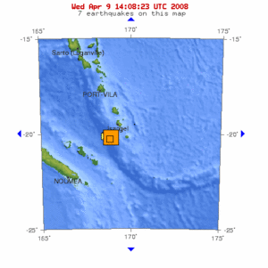
| 10-degree Map Centered at 20°S,170°E |
Magnitude: 7.3
Date-Time:
* Wednesday, April 09, 2008 at 12:46:13 UTC
* Wednesday, April 09, 2008 at 11:46:13 PM at epicenter
* Time of Earthquake in other Time Zones
Location: 20.058°S, 168.858°E
Depth: 35 km (21.7 miles) set by location program
Region: LOYALTY ISLANDS
Distances:
85 km (55 miles) SSW of Isangel, Tanna, Vanuatu
175 km (110 miles) NE of Tadine, Loyalty Islands, New Caledonia
275 km (170 miles) S of PORT-VILA, Efate, Vanuatu
1800 km (1120 miles) ENE of BRISBANE, Queensland, Australia
Location Uncertainty: horizontal +/- 7 km (4.3 miles); depth fixed by location program
Parameters: NST=140, Nph=140, Dmin=>999 km, Rmss=1.14 sec, Gp= 47°, M-type=moment magnitude (Mw), Version=8
Source
* USGS NEIC (WDCS-D)
Update time = Wed Apr 9 16:21:19 UTC 2008
           UTC DATE-TIME       LAT        LON   DEPTH

MAG       y/m/d h:m:s          deg         deg      km    Region

5.1   2008/04/09 16:02:12   -20.302    168.930  35.0   LOYALTY ISLANDS

6.0   2008/04/09 14:47:51   -20.019    168.862  35.0   LOYALTY ISLANDS

5.4   2008/04/09 14:21:21   -20.094    168.730  35.0   LOYALTY ISLANDS

5.4   2008/04/09 14:11:44   -20.135    168.816  32.2   LOYALTY ISLANDS

5.2   2008/04/09 13:03:07   -20.141    168.802  35.0   LOYALTY ISLANDS

7.3   2008/04/09 12:46:13   -20.058    168.858  35.0   LOYALTY ISLANDS

5.9   2008/04/09 11:23:40   -20.191    168.906  35.0   LOYALTY ISLANDS

6.2   2008/04/09 11:13:21   -20.168    168.768  35.0   LOYALTY ISLANDS
Event ID: us2008qqa2


Reader Comments
to our Newsletter