OF THE
TIMES
"We have about 50% of the world's wealth but only 6.3% of its population. This disparity is particularly great as between ourselves and the peoples of Asia. In this situation, we cannot fail to be the object of envy and resentment. Our real task in the coming period is to devise a pattern of relationships which will permit us to maintain this position of disparity without positive detriment to our national security. To do so, we will have to dispense with all sentimentality and day-dreaming; and our attention will have to be concentrated everywhere on our immediate national objectives. We need not deceive ourselves that we can afford today the luxury of altruism and world-benefaction."
~ US State Department, 1948
A powerful share that is filled with spiritual wisdom. [Link]
It is a sad thing to see the Western world, supposed bastion of freedom, individual rights, "multiculturalism".... complacently agreeing with the...
The true organizers of BLM will NEVER see justice.
With no evidence of net, or even any, benefit, and clear evidence of a devastating death toll, this study's important findings show that even for...
archaeologists determined that the site was occupied during different time periods. as a motocross track, they quickly disposed of the bikes in...
To submit an article for publication, see our Submission Guidelines
Reader comments do not necessarily reflect the views of the volunteers, editors, and directors of SOTT.net or the Quantum Future Group.
Some icons on this site were created by: Afterglow, Aha-Soft, AntialiasFactory, artdesigner.lv, Artura, DailyOverview, Everaldo, GraphicsFuel, IconFactory, Iconka, IconShock, Icons-Land, i-love-icons, KDE-look.org, Klukeart, mugenb16, Map Icons Collection, PetshopBoxStudio, VisualPharm, wbeiruti, WebIconset
Powered by PikaJS 🐁 and In·Site
Original content © 2002-2024 by Sott.net/Signs of the Times. See: FAIR USE NOTICE


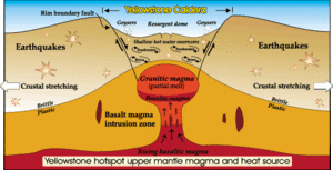
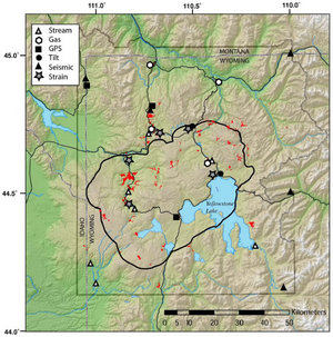
Comment: The University of Utah, as a member of the Advanced National Seismic System (ANSS), maintains a series of seismograph stations at Yellowstone National Park. Recent readings capturing a short series of quakes can be seen at their site.