|
| ©NOAA |
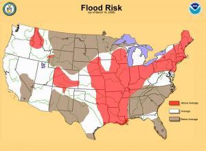
| Map of US spring flood risk. |
The science supporting NOAA's short-term forecasts allows for a high level of certainty. National Weather Service forecasters highlighted potential for the current major flood event a week in advance and began working with emergency managers to prepare local communities for the impending danger.
"We expect rains and melting snow to bring more flooding this spring," said Vickie Nadolski, deputy director of NOAA's National Weather Service. "Americans should be on high alert to flood conditions in your communities. Arm yourselves with information about how to stay safe during a flood and do not attempt to drive on flooded roadways - remember to always turn around, don't drown."
Nadolski called on local emergency management officials to continue preparations for a wet spring and focus on public education to ensure heightened awareness of the potential for dangerous local conditions.
Above-normal flood potential is evident in much of the Mississippi River basin, the Ohio River basin, the lower Missouri River basin, Pennsylvania, New Jersey, most of New York, all of New England, and portions of the West, including Colorado and Idaho:
Heavy winter snow combined with recent rain indicates parts of Wisconsin and Illinois should see minor to moderate flooding, with as much as a 20 to 30 percent chance of major flooding on some rivers in southern Wisconsin and northern Illinois.
Current snow depth in some areas of upstate New York and New England is more than a foot greater than usual for this time of the year, which increases flood potential in the Connecticut River Valley.
Locations in the mountains of Colorado and Idaho have 150 to 200 percent of average water contained in snowpack leading to a higher than normal flood potential.
Snowfall has been normal or above normal across most of the West this winter; however, preexisting dryness in many areas will prevent most flooding in this region. Runoff from snow pack is expected to significantly improve stream flows compared to last year for the West.
The drought outlook indicates continued general improvement in the Southeast, although some reservoirs are unlikely to recover before summer. Winter precipitation chipped away at both the western and southeastern drought. On the U.S. Drought Monitor, extreme drought coverage dropped from nearly 50 percent in mid-December to less than 20 percent in the Southeast for March.
Overall, the Southeast had near-average rainfall during the winter with some areas wetter than average. Nevertheless, lingering water supply concerns and water restrictions continue in parts of the region.
Drought is expected to continue in parts of the southern Plains despite some recent heavy rain. Parts of Texas received less than 25 percent of normal rainfall in the winter, leading 165 counties to enact burn bans by mid-March. Seasonal forecasts for warmth and dryness suggest drought will expand northward and westward this spring.
During the spring season, weather can change quickly - from drought to flooding to severe weather, including outbreaks of tornadoes.
Adapted from materials provided by National Oceanic And Atmospheric Administration.


Reader Comments
to our Newsletter