Extreme Temperatures
S


Snowflake Cold

June snow again in USA as inter-tropical convergence zone shifts

June snow USA
© YouTube/Adapt 2030 (screen capture)
More June snows across the western states of the USA and a Nor'easter travels up the east coast of the USA and Canada this week with snow possible. The trend is clear that later and later snows have begun in 2015 with July snow through 3 of the last 3 years in the western USA. As with every grand solar minimum the inter-tropical convergence zone shifts, and with it brings unseasonable weather patterns as the new norm.


Snowflake

More snow for the Rockies and Cascades

rocky montain snow
Six or more inches (15 cm) of snow are possible this weekend across the highest elevations of the Washington and Oregon Cascades.

Several inches of snow could also hit higher parts of Idaho, western Montana, western Wyoming, northeast Utah, and northern Colorado into Tuesday, according to the Weather Channel.

With temperatures running 10 to 20 degrees colder than average at times, snow levels are forecast to fall to between 5,000 and 6,500 feet.

Where's all that vaunted global warming?!!

Thanks to Dean Koehler, Craig Adkins and Gordon Broussard for this link

Comment: And Summer is just a few weeks away:
Ski resorts open on six continents as snow falls or remains on slopes worldwide
California's endless winter: 8 feet of snow remains on the ground in June


Snowflake

Drought followed by snow for storm-ravaged Western Cape, South Africa

Sutherland this morning.
© Snow Report SA‏Sutherland this morning.
Last week the Western Cape government declared the province a disaster area because of the severe drought.

This week residents were warned to stay indoors to escape the wrath of the worst storm Cape Town had seen in 30 years. Gale force winds, rain, and now a thick blanket of snow has covered certain areas.

The storm that battered the city throughout Wednesday moved inland to Matroosberg, turning the torrential downpour into snow. Employees and guests at Matroosberg lodge awoke to a 10 cm of snow.

"The amount of snowfall we received is a lot for this time of the year. We have had people from Cape Town calling all day to come see it and enjoy," lodge manage Didi de Kock said.


Snowflake

Ski resorts open on six continents as snow falls or remains on slopes worldwide

Snow slope
With the start of the ski season in Southern Africa, ski areas are open on six continents simultaneously, as of this weekend.

This is partly thanks to the fact that resorts will open for their winter or summer ski seasons on five continents this weekend.

Fresh snow has also fallen or is reported to be due to fall over the weekend in the Alps, Western North America, Africa, Australia, New Zealand and south America, so it's a snowy June picture on ski slopes worldwide.

About half a dozen ski areas are still operating in each of Europe and North America (with Val d'Isere and Whistler Blackcomb due to re-open for summer glacier skiing this weekend and Mammoth pictured still open since last season) and the Gassan spring and summer ski area in Japan, Asia is also open in the northern hemisphere.

Snowflake Cold

Southern Hemisphere cooling trend is now apparent

Adelaide coldest start to winter
© YouTube/Adapt 2030 (screen capture)
With the Southern Hemisphere winter getting underway we need to look back at trends to see the future of the coming year. David Archibald has today given the most up to date information on our Sun entering a grand solar minimum and the State of the Sun, now with the past 5 winters under our belts we can look for trends. I present to you the trend of a cooling Southern Hemisphere.


Comment: See also:


Ice Cube

Oops - Polar ice not receding after all?

NASA satellite measurements show polar ice caps
NASA satellite measurements show the polar ice caps have not retreated at all.
In fact it may be standing at its greatest extent in at least 97 years. Al Gore predicted that the Arctic ice cap could completely disappear by 2014.

However, new data released by NASA reveals that the Earth's polar ice caps have not receded at all since satellite measurements began in 1979.

Considering that the late 1970s marked the end of a 30-year cooling trend, the polar ice caps were quite likely more extensive at that time than they had been since at least the 1920s.

This indicates that not only is polar ice not receding, it is now quite possibly at its greatest extent in at least 97 years.

Thanks to Dale for this link

Comment: See also: Arctic Sea Ice Expanded in May - and in the unlikely place of Barents Sea


Ice Cube

Arctic Sea Ice Expanded in May - and in the unlikely place of Barents Sea

May Northern Hemisphere ice map
Light blue line shows 2017 ice extent
As of May 15, sea ice in the Barents Sea was growing like crazy. "Something surprising is happening with Arctic ice," wrote Ron Clutz. "It is May and ice should be melting, but instead it is growing and in the unlikely place of Barents Sea." "In recent days 2017 NH ice extents have grown way above average." The ice is refusing to leave Newfoundland, says Clutz. And instead of backing down in the Barents Sea, it is increasing. See map showing ice growth.
Barents Sea ice

Cloud Grey

Equal coldest start to winter on record for Adelaide, Australia

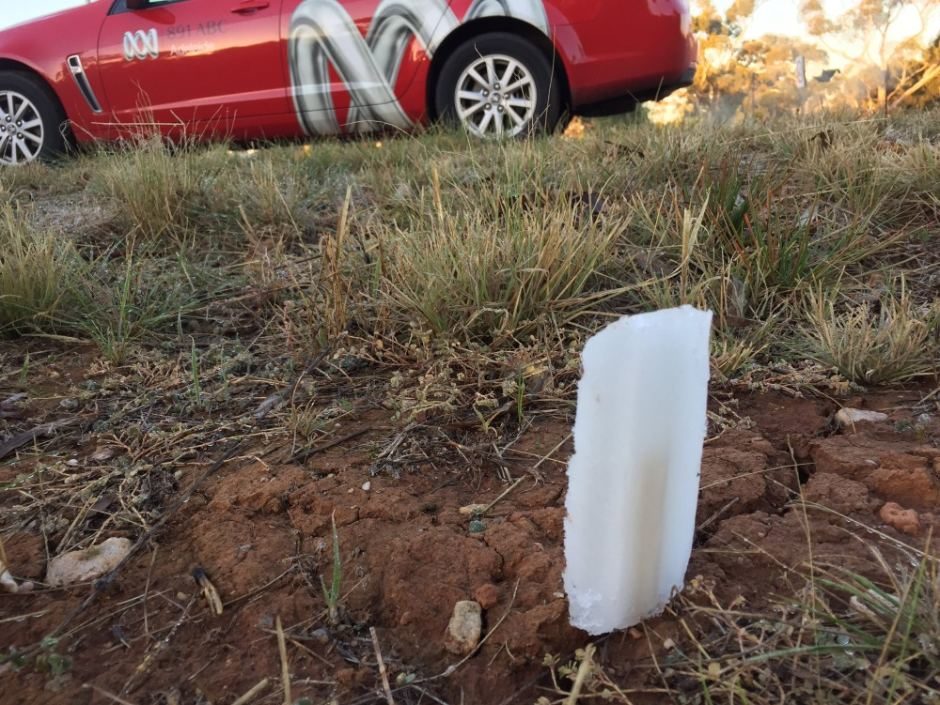
 ABC Radio conducted an icy pole test in Adelaide to see how cold it was this morning.
© Spence Denny ABC Radio conducted an icy pole test in Adelaide to see how cold it was this morning.
Did you think the first day of winter felt a little nippy? Well, if you were in Adelaide it wasn't all in your head because the city has shivered through its coldest start to the season with the temperature dropping to just 2.9 degrees Celsius.

Duty forecaster Paul Bierman confirmed the city had its equal coldest June 1 on record, a temperature not seen since 1943.

"The minimum temperature at Kent Town got down to 2.9 degrees at 6:44am this morning. It has already started to warm up slightly, we're up to 3.3 degrees," he said just before 8:00am.

He said a cold front that moved across the state earlier in the week combined with overnight light winds and clear skies to produce the chilly morning.

"[We're going to have] very cold mornings right through until at least next Sunday ... around 3 or 4C," Mr Bierman said.

Info

Unusual rains and record snowfall continues as cosmic rays increase

Galactic cosmic rays
© YouTube/Adapt 2030 (screen capture)
There has been a steady progression of events with unusual rains or snows in record amounts which are out of season from Asia to North America. Now there is coldest start to winter in Adelaide Australia in the last 103 years , June skiing in Vermont and snow still falls in Idaho. The progression of unusual events is caused by increasing cosmic rays, which will continue to increase through solar cycle 25 and so shall our increasingly strange weather.


Comment: See these related articles for more information:


Better Earth

Surprising Convergence of Day and Night Upper-Atmosphere Temperatures

upper atmosphere
A cursory review of articles about the upper atmosphere reveals many theories about the role of CO2 on temperatures aloft. By "Upper Atmosphere" we mean the region above the surface and below 100,000 feet. Actually, in this article, we will only concern ourselves with the region from 850 millibars to 100 millibars, which is about 5,000 feet to 55,000 feet.

In the early days of Global Warming, the theories predicted that the upper atmosphere would heat due to increases in CO2. Well, that didn't happen. One recent article by NASA says that the Thermosphere (above 100,000 ft) has cooled in recent years due to decreased solar activity and a reduction in ultraviolet light. That certainly seems reasonable. Another article stated that if the lower atmosphere warms, the upper atmosphere must cool, which makes no sense to me.

Other articles posit that as CO2 increases the level at which radiation escapes to space also increases and the upper atmosphere warms. That also made no sense to me.

I decided to take a look at temperatures aloft and reasoned that the difference between day and night temperatures in the upper atmosphere might reveal whether the nighttime atmosphere is cooling faster or slower than in previous years. If cooling slower the temperature curves at 00z and 12z would tend to converge and if cooling faster the curves would diverge. Simple, right?