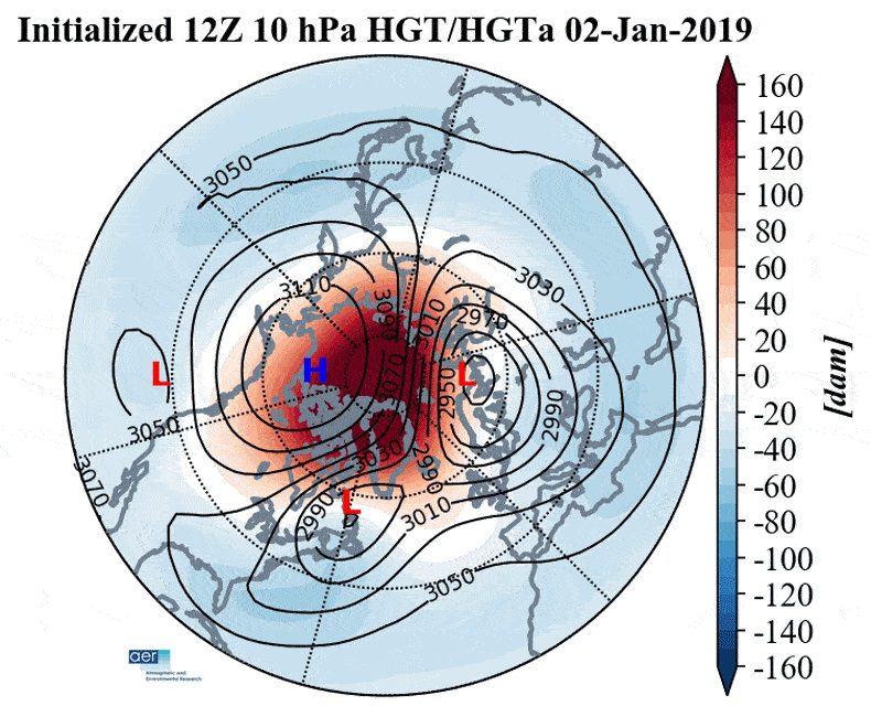
How it works: The possible changes are being triggered by a sudden and drastic warming of the air in the stratosphere, some 100,000 feet above the Arctic, and by a resulting disruption of the polar vortex - an area of low pressure at high altitudes near the pole that, when disrupted, can wobble like a spinning top and send cold air to the south. In this case, it could split into three pieces, and those pieces would determine who gets hit the hardest.
The big picture: Studies show that what happens in the Arctic does not stay in the Arctic, and rapid Arctic warming may paradoxically be leading to more frequent cold weather outbreaks in Europe, Asia and North America, particularly later in the winter.
During the past 2 weeks, a sudden stratospheric warming event has taken place, showing up first in the Siberian Arctic, and then spreading over the North Pole.
- Such events occur when large atmospheric waves surge beyond the troposphere and into the layer of air above it. Such a vertical transport of energy can rapidly warm the stratosphere, and set in motion a chain reaction that disrupts the stratospheric polar vortex.
- Sudden stratospheric warming events are known to affect the weather in the U.S. and Europe on a time delay - typically on the order of a week to several weeks later, and their effects may persist for more than a month.
"In general, we see colder than normal temperatures over much of the U.S. and Europe/Northern Asia, and warmer than normal temperatures over Greenland and subtropical Africa/Asia" in the 60 days following sudden stratospheric warming events, Amy Butler, a research scientist at the Cooperative Institute for Research in Environmental Sciences, told Axios in an email.
What's next: Polar vortex projections show it's likely to split into possibly as many as 3 "sister vortices," spilling cold air out of the Arctic and concentrating it in spots across Eurasia and North America.
- In the past, polar vortex splits have been associated with major snowstorms, including 2010, when the Mid-Atlantic region was buried by blizzards.
- A sudden stratospheric warming event and polar vortex disruption was associated with several March snowstorms in the Northeast last winter, as well as the "Beast from the East" cold spell in Europe.
- Such events can have major ramifications for energy markets, leading to natural gas price spikes, for example.
- Cohen and Michael Ventrice, a meteorologist at The Weather Company, told Axios that there are increasing signs of high pressure forming over the North Atlantic near Greenland as well as close to the North Pole in late January, which can block the progress of weather systems moving from west to east.
- Such blocking patterns may be a manifestation of the polar vortex disruption, and favor colder and stormier weather in the eastern U.S. and parts of Europe.
- "Eventually we do think this blocking will set up," Ventrice said. "I would not give up on winter."


Reader Comments
Research Valentina Zharkova and the Grand Solar minimum. Crop losses are already showing effects on food prices globally. They will use Trump, Brexit, Terror and Russia to distract you from this.
The Saker: From 2018 to 2019 - A quick survey of some major geopolitical trends to make note of
The year 2018 will go down in history as a turning point in the evolution of the geostrategic environment of our planet. There are many reasons for that and I won't list them all, but here are...