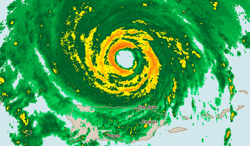
After clobbering the Lesser Antilles islands of Barbuda, Saint Barthelemy, Anguilla, and Saint Martin/Sint Maarten early Wednesday morning, Hurricane Irma carried its march of destruction into the British Virgin Islands on Wednesday afternoon, still packing top winds of 185 mph. As of 5 pm EDT Wednesday, Irma had spent a remarkable 1.5 days as a Category 5 hurricane, which is the 7th longest stretch on record in the Atlantic, according to Dr. Phil Klotzbach.
Longer-range outlook for Irma: Cuba, The Bahamas, and Southeast U.S.
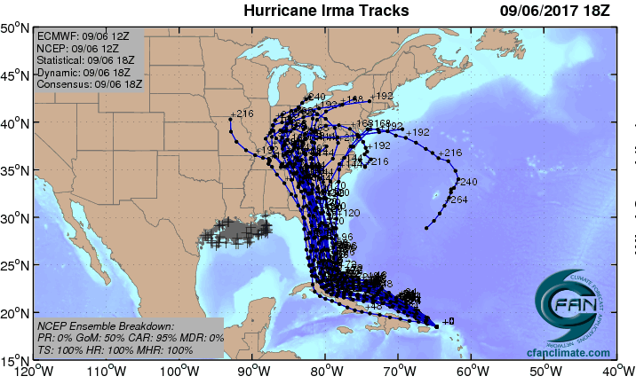
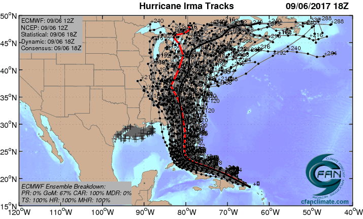
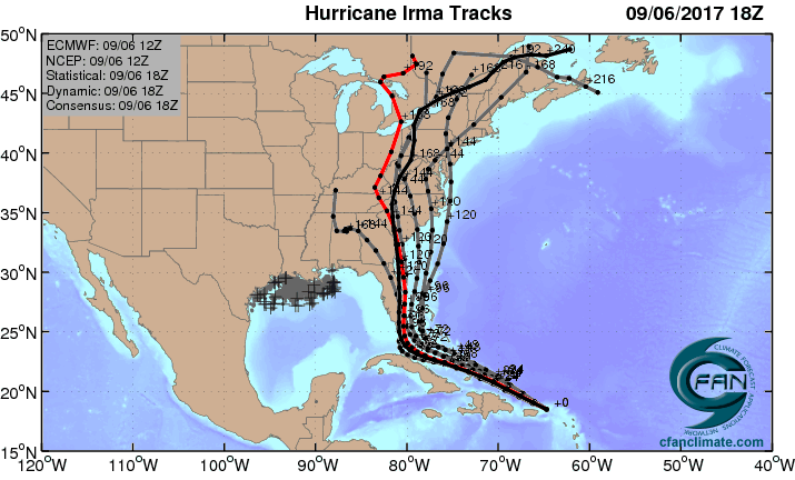
The 12Z Wednesday runs of our top four track models-the European, GFS, HWRF, and UKMET models-were in strikingly close agreement that Irma will continue on a west-northwest track till Saturday, then arc sharply to the north-northwest. All four model runs placed the center of Irma within roughly 50 miles of Miami on Sunday morning; the latest 18Z GFS was also there. The average track error in a 4-day forecast is 175 miles, but this remarkable agreement among the models lends additional confidence to the NHC forecast track, which brings Irma over or very near southeast Florida on Sunday. All four models move Irma northward along or near Florida's east coast, with landfall in Georgia or South Carolina on Monday.
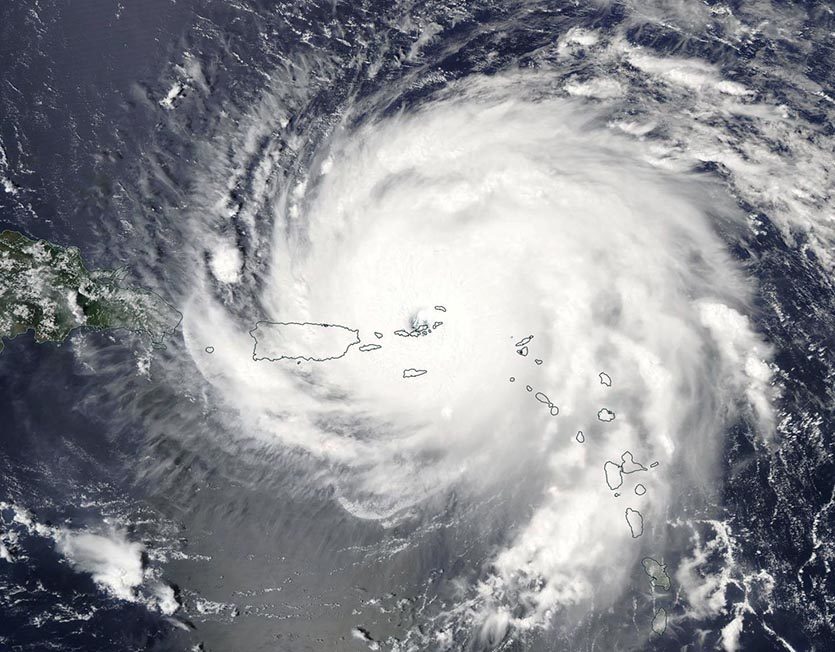
Bahamas: From late Thursday into Friday, Irma will be moving through or just south of the Southeast Bahamas, which are under a Hurricane Warning along with the Central Bahamas. Irma has the potential to be a devastating storm for The Bahamas, especially its southern islands, and residents should rush any needed preparations to completion.
Cuba: From Friday into Saturday, Irma will be paralleling the north coast of Cuba, and it is possible Irma's center will move just inland along the coast for some period of time. Parts of central Cuba are within the "cone of uncertainty" in the official NHC forecast. Residents of Cuba will need to pay very close attention to Irma's track. The eastern two-thirds of Cuba was under a Hurricane Watch as of Wednesday afternoon. Irma is not expected to cross Cuba and move into the Caribbean.
Florida: Where and when Irma makes its right-hand turn will largely determine its track with respect to the Florida peninsula. Based on recent ensemble models (in which a large number of parallel runs are carried out to simulate uncertainty in the atmosphere), it is still possible that Irma could take a south-to-north inland track across the Florida peninsula, or a track that stays just east of Florida's East Coast. However, it appears most likely that Irma will hug the state's East Coast from south to north, potentially moving inland over some sections. This type of track is far different from those of Hurricane Andrew (1992) and Katrina (2005), which moved from east to west across the Miami metro area. A south-to-north track would affect a much larger part of this elongated metroplex. In an interview published in Capital Weather Gang in August, Bryan Norcross touches on the many issues that a hurricane like Irma could bring to South Florida, which has not experienced a storm this strong in 25 years.
Depending on Irma's track, hurricane conditions could extend well inland, as well as northward along the length of the peninsula. The entire Florida peninsula is within the five-day cone of uncertainty in the official NHC forecast, and all residents of these areas should pay close attention to the progress of Irma, especially along Florida's East Coast. NHC may issue Hurricane Watches for parts of South Florida and the Keys on Thursday.
Irma's intensity will likely undergo fluctuations over the next couple of days, but intensity models show only gradual weakening, and NHC maintains Irma as a Cat 5 storm through Friday. Wind shear is predicted to remain low to moderate along Irma's path until Saturday, and Irma will be passing over waters that are as warm or slightly warmer than its current environment (see discussion in our Tuesday PM post). Land interaction with Cuba could weaken Irma somewhat, but we must assume that Irma will be at least a Category 4 as it nears South Florida on Sunday, as predicted by NHC.
Georgia/South Carolina/North Carolina: The GFS, European, and UKMET models from 12Z Wednesday track Irma from just off the northeast Florida coast inland near the Georgia/South Carolina border on Monday. The official NHC forecast places Irma near the Georgia coast on Monday afternoon at Category 3 strength. Even if Irma's winds weaken and its Saffir-Simpson category drops, Irma could still be capable of extreme storm surge, depending on its track and the geography of its landfall location(s). Storm surge expert Dr. Hal Needham noted in a blog post Wednesday: "The region from northeast Florida (St. Augustine) through all of the Georgia coast and southwest South Carolina is particularly vulnerable to storm surge, whether or not Irma makes a direct landfall in that region."
Irma's storm surge
Irma is a medium-large hurricane, and is expected to grow in size as it progresses west-northwest over the next four days. As of 5 pm EDT Wednesday, the diameter of hurricane-force winds surrounding Irma was up to 105 miles wide, and the diameter of tropical storm-force winds was up to 310 miles. The official NHC forecast predicted that these diameters would grow to 115 miles and 345 miles, respectively, by Friday, when Irma will be pounding the central Bahamas. This increase in size will be due to eyewall replacement cycles, which spread out the wind field over a larger area, and due to the fact that storms moving towards the pole get more spin from the Earth's spin.
Irma's large wind field is putting in motion a vast amount of water, which is spiraling into the center of Irma and creating a large mound. In the open ocean, that water is forced downward, pushing deeper water outward, and the sea surface is not elevated more than a few feet. However, once the hurricane drives that mound of water into a shallow area near land, the water cannot flow downwards, and instead piles up and is forced on land, creating a storm surge. In the Turks and Caicos Island and in the southeastern and central Bahamas, a highly destructive storm surge of 15 - 20 feet above ground is expected near the coast to the right of where the eyewall hits.
A potentially catastrophic storm surge for Florida, Georgia, and South Carolina
If Irma makes a trek up the East Coast from Miami to southern South Carolina as a Category 3 or 4 hurricane, as the models currently suggest, the portions of the coast that the eyewall touches will potentially see a massive and catastrophic storm surge, breaking all-time storm surge records and causing many billions of dollars in damage. Even areas up to a hundred miles to the north of where the center makes landfall could potentially see record storm surges. The area of most concern is the northern coast of Florida, the coast of Georgia, and the southern coast of South Carolina, due to the concave shape of the coast, which will act to funnel and concentrate the storm surge to ridiculous heights. If we look at wunderground's storm surge maps for the U.S. East Coast, we see that in a worst-case Category 3 hurricane hitting at high tide, the storm tide (the combined effect of the storm surge and the tide) ranges from 17 - 20' above ground along the northern coast of Florida, and 18 - 23 feet above ground along the Georgia coast. If Irma is a Cat 4, these numbers increase to 22 - 28 feet for the coast of Georgia. This is a Katrina-level storm surge, the kind that causes incredible destruction and mass casualties among those foolish enough to refuse to evacuate.
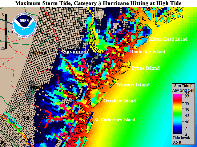
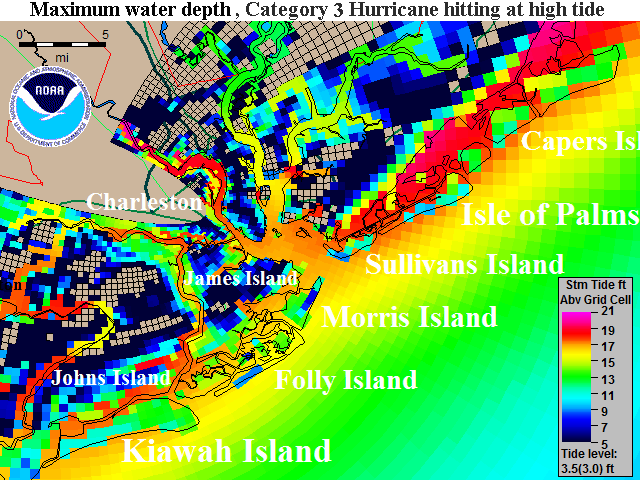
The image was created using the National Hurricane Center’s Sea, Lake, and Overland Surge from Hurricanes (SLOSH) model. This model divides the U.S. coast up into 20 or so separate grids (called basins) that storm surge simulations are performed for. If one takes the maximum the water reaches at any point in time at every grid cell in a SLOSH basin, a composite "Maximum Envelope of Water" (MEOW) plot can be made. MEOW plots are created for every category of storm moving in a particular direction, usually stratified by forward speed and tide elevation. Simulations are run using a variety of storm sizes. If one takes the maximum storm surge height for all the MEOW plots at every grid cell, one can generate a worst-case storm surge for the coast for each Saffir-Simpson hurricane category: 1, 2, 3, 4, and 5. These so-called "Maximum Of the MEOWs", or "MOMs" are what are plotted in the SLOSH storm surge images on wunderground, and are the composite worst-case scenario storm surges from about 15,000 different hypothetical hurricanes for each SLOSH basin. All of the MOM images we provide are for high tide, and were performed using the 2009 version of the SLOSH Display Package provided to wunderground by the National Oceanic and Atmospheric Administration (NOAA). Interstate highways are the thick grey-green lines, and smaller highways are shown as dark green and light green lines. If a road is inundated by storm surge, it will not appear. County boundaries are shown in red.
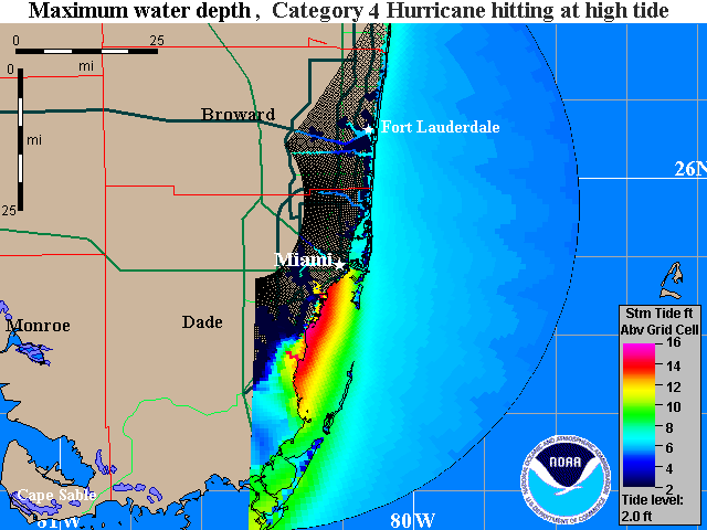
Shown here is the Maximum of the "Maximum Envelope of Waters" (MOM) storm tide image for a composite maximum surge for a large suite of possible mid-strength Category 4 hurricanes (sustained winds of 140 mph) hitting at high tide (a tide level of 2.0’) along the coast of South Florida. Not all sections of the coast will experience this surge level simultaneously.
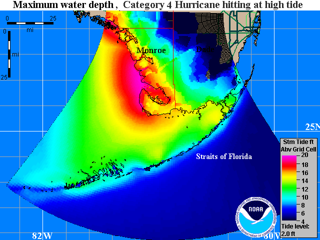
Shown here is the Maximum of the "Maximum Envelope of Waters" (MOM) storm tide image for a composite maximum surge for a large suite of possible mid-strength Category 4 hurricanes (sustained winds of 140 mph) hitting at high tide (a tide level of 2.0’) affecting the Florida Keys. Not all sections of the coast will experience this surge level simultaneously.
Two more hurricanes: Jose and Katia
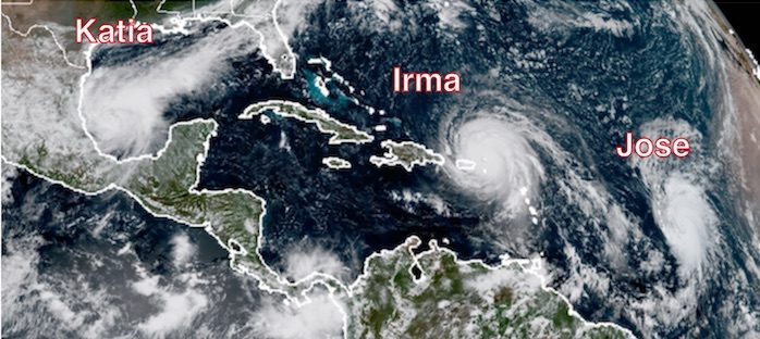
Forecasters at the National Hurricane Center have their hands full with two new hurricanes joining Irma on Wednesday afternoon. Not since 2010 has the Atlantic had three hurricanes at once, as noted by David Roth (NOAA/NWS) on Twitter. The Atlantic record for simultaneous hurricanes is four, set in 1893 and 1998. The 2017 hurricane season to date is more than twice as active as usual-we've had a season's worth of named storms, hurricanes, and intense hurricanes before even getting to the climatological halfway point of the season (September 10). Phil Klotzbach noted on Twitter that only one other Atlantic season, 1893, has seen this many hurricanes (six) forming between Aug. 7 and Sept. 6.
Rapidly strengthening Hurricane Jose was located about 1040 miles east of the Lesser Antilles at 5 pm EDT Wednesday, with top sustained winds at 75 mph. Jose is headed at 16 mph on a steady west to west-northwest track, steered by the same ridge that is helping to direct Irma. Jose is just far enough east of Irma for the two storms to coexist without one impeding the other. Jose is traveling over warm SSTs of 28-29°C (82-84°F) in a moist atmosphere (mid-level relative humidity around 65%), and wind shear is predicted to remain around 10 knots for the next day or so. This should allow Jose to strengthen at a rapid clip, and NHC predicts Jose will be a major Category 3 hurricane by Friday. Increasing wind shear from that point on should tamp down the rapid intensification and may weaken Jose over time. On its current track, Jose would reach the northern Leeward Islands by Saturday, but the ridge is predicted to weaken enough by Saturday to allow Jose to arc just northeast of the islands.
Only a tropical depression early Wednesday, Hurricane Katia has also intensified quickly, with estimated top winds of 75 mph as of 5 pm EDT. Located in the Bay of Campeche about 185 miles north-northeast of Veracruz, Mexico, Katia is embedded in a very moist environment with numerous showers and thunderstorms along and south of a frontal zone. Wind shear will decrease to 5-10 knots by Thursday, and with help from the bay's very warm waters (30-31°C or 86-88°F), Katia could continue to strengthen dramatically. The SHIPS model's rapid intensification index indicates a near-even chance that Katia's top sustained winds will increase by 45 mph by late Thursday, although the official NHC forecast at 5 pm EDT Wednesday brings Katia only to top-end Cat 1 intensity. Our top track models are unanimous in drifting Katia for a couple of days before driving it southwestward into the Mexican coast this weekend. Extremely heavy rains of 10 - 20" are possible along and near parts of the northeast Mexican coast, especially in the state of Veracruz, as Katia approaches and moves inland.


Reader Comments
to our Newsletter