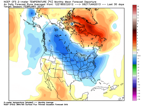
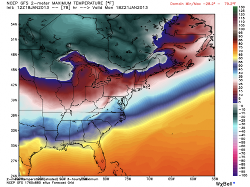
While the physics behind sudden stratospheric warming events are complicated, their implications are not: such events are often harbingers of colder weather in North America and Eurasia. The ongoing event favors colder and possibly stormier weather for as long as four to eight weeks after the event, meaning that after a mild start to the winter, the rest of this month and February could bring the coldest weather of the winter season to parts of the U.S., along with a heightened chance of snow.
Sudden stratospheric warming events occur when large atmospheric waves, known as Rossby waves, extend beyond the troposphere where most weather occurs, and into the stratosphere. This vertical transport of energy can set a complex process into motion that leads to the breakdown of the high altitude cold low pressure area that typically spins above the North Pole during the winter, which is known as the polar vortex.
The polar vortex plays a major role in determining how much Arctic air spills southward toward the mid-latitudes. When there is a strong polar vortex, cold air tends to stay bottled up in the Arctic. However, when the vortex weakens or is disrupted, like a spinning top that suddenly starts wobbling, it can cause polar air masses to surge south, while the Arctic experiences milder-than-average temperatures.
During the ongoing stratospheric warming event, the polar vortex split in two, allowing polar air to spill out from the Arctic, as if a refrigerator door were suddenly opened.
When the sudden stratospheric warming event began in early January, that signaled to weather forecasters that a cool down was more likely to occur by the end of the month, since it usually takes many days for developments in the stratosphere to affect weather in the troposphere, and vice versa.
"For reasons I don't think we fully understand, the changes in the circulation that happen in the stratosphere [can] descend down all the way to the Earth's surface," said Judah Cohen, director of seasonal forecasting at Atmospheric and Environmental Research (AER) in Massachusetts.
As the polar stratosphere warms, high pressure builds over the Arctic, causing the polar jet stream to weaken. At the same time, the midlatitude jet stream strengthens, while also becoming wavier, with deeper troughs and ridges corresponding to more intense storms and high pressure areas. In fact, sudden stratospheric warming events even make so-called "blocked" weather patterns more likely to occur, which tilts the odds in favor of the development of winter storms in the U.S. and Europe.
Cohen was the lead author of a 2009 study that found that sudden stratospheric warming events are becoming more frequent, a trend that may be related to an increase in fall snow cover across Eurasia. The increase in snow cover has in turn been tied to the rapid loss of Arctic sea ice, since the increase in open water in the fall means that there is more atmospheric moisture available to fall as rain or snow.
Cohen and his colleagues at AER have been using an index of Eurasian snow cover during the month of October in order to make seasonal weather forecasts for the following winter, and he said that by using this technique, they successfully predicted the ongoing stratospheric warming event 30-days in advance.
"As far as I know this is a first and has huge implications for intraseasonal predictions," he said.
Cohen's research has also pointed to stratospheric warming events as one of the reasons why the second half of recent winters in the Northern Hemisphere have turned out to be colder than the first half.

When the vortex becomes dislodged from the pole, Cohen said, it can lead to a flow of air that is more north to south than west to east. "So when the warm air rushes the pole it displaces the cold air over the pole and forces it equatorward," Cohen said.
This has major implications for U.S. winter weather.
High temperatures in North Dakota and Minnesota may not make it above zero Fahrenheit on Sunday and Monday. If Minneapolis records a high temperature below zero it will end its record-breaking streak of four years without such an occurrence. By Tuesday, the cold air will have spilled into Kentucky and Maryland as well as New England. And the long-range outlooks suggest that February is going to be a colder-than-average month from the Upper Midwest to the East Coast, although there may be brief breaks from the cold depending on the prevailing storm track.
Anthony Artusa, a seasonal climate forecaster at the National Oceanic and Atmospheric Administration (NOAA), said the cold air spilling southward for the inauguration may mark the beginning of a long-lasting cold period that is related to the stratospheric warming event. "It does look like this could be the early effects of it," he said during a conference call with reporters on Thursday.
Related Content:
Winter Outlook Offers Hope For Skiers and Boarders
A Closer Look At Arctic Sea Ice Melt and Extreme Weather
Visualizing 2012's Record Arctic Sea Ice Melt
Warming Arctic May Be Causing Cooler Winters in Eastern U.S., Europe


I think it would be better to post from the original article as the editor at extinction protocols missed certain things out that could help with the understanding. Apart from that it also has the name of the author of the article. Original is here [Link]