The new low is expected to move west over the next day, with the weather bureau predicting it will be around 300km off Noosa by early tomorrow.
Residents on Fraser Island through to the Sunshine and Gold Coasts were today warned of damaging winds and dangerous surf causing coastal inundation.
"Very large waves are expected to develop on top of the current swells causing dangerous conditions today and into Friday," a weather bureau spokesman said.
"Wave heights are expected to gradually decrease Friday afternoon.
"Winds are also expected to increase along coastal areas during today, with gusts likely to reach 90 km/h in more exposed parts which will then ease during Friday."
Increasing rainfall overnight and into early tomorrow could lead to flash flooding around the southeast coast, and west towards the Dividing Range.
The warning prompted the State Emergency Service (SES) to urge the public to have respect for the danger of floodwaters.
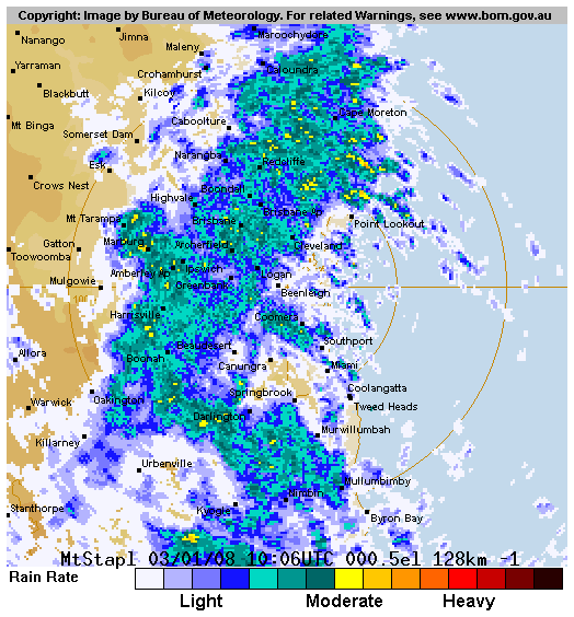
|
| ©Australian Bureau of Meteorology |
| Brisbane (Mt Stapylton) Radar of current rain rates as of 3 January 2007. Outer circle has radius of 128km. |
Southeast regional director Eddie Bennett said teams were already responding to a handful of jobs related to the heavy rain, and expected more.
But he hoped none of them involved people swept away by floods.
"Too often people attempt to drive through floodwaters, only to find that their engines stall, stranding them in rising torrents," Mr Bennett said.
"A similar danger occurs when people attempt to drive across bridges with floodwaters rushing over them."
Also expecting a busy time ahead is Energex, the energy supplier already having restored power to 93,000 homes since Christmas.
Spokesman Mike Swanston said most outages were caused by trees and household items blowing on to powerlines, and urged householders to secure loose objects before the next storms.
Residents in the eastern Gulf of Carpentaria and the Torres Strait were also warned of abnormally high tides, large waves and strong northwesterly monsoon winds over the next 24 hours.
The winds were expected to raise tide levels through to Sunday in areas north from Weipa and through the Torres Strait.
Despite ruining Christmas holidays for many in the south, the poor weather has delivered an extra two weeks' supply for the shrinking Somerset, North Pine and Wivenhoe dams in southeast Queensland.
SEQWater said some parts of the catchments of the Somerset and North Pine dams had received up to 20mm overnight.
The combined dam level now sits at 20.64 per cent.
While holidaymakers were still being urged to stay away from beaches, visitors were allowed some access to Fraser Island from today.
Campers on the eastern side of the island were evacuated last week because of the wild weather.
The weather bureau predicted the weather would clear by the weekend, bringing mostly sunny and humid conditions.
While holiday-makers were still being urged to stay away from beaches, visitors will be allowed some access to Fraser Island from today.
Queensland Parks and Wildlife Service will resume issuing vehicle access permits to visitors, but only for travel inland and on the western side of the island, and accommodation facilities and townships on the eastern side accessible by roads or tracks.
Campers on the eastern side of the island were evacuated last week because of the wild weather.
The weather bureau predicted the weather would clear by the weekend, bringing mostly sunny and humid conditions.
Meteorologists recorded five lows yesterday, spread across Western Australia, the Northern Territory and Queensland, with one having the potential to develop into a cyclone.
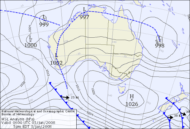
|
| ©Australian Bureau of Meteorology |
| Colour mean sea level pressure analysis around continental Australia as of 3 January 2007 |
Traveston Bridge, the site of the controversial Mary River dam, was also in flood, prompting Queensland Water Infrastructure chief executive Graeme Newton to say it showed the planned storage was in the right place.
Mr Newton said 11,500 megalitres a day was flowing through the site and, since a major flood in August last year, there had been four significant flows greater than 1000 megalitres a day.
These would have seen the dam full or near to full.
"It's within 20km of the coast so it picks up these coastal rainfall events," Mr Newton said.
Mary River Action Group spokesman Kevin Ingersole said the small flow was irrelevant given there was no need to build the dam and the $1.6 billion construction costs would be better spent on desalination plants.
Combined levels of Wivenhoe, Somerset and North Pine reached 20.26 per cent of capacity yesterday. SEQWater spokesman Rob Drury said it was the most promising start to a summer in years.
"Conditions look really unsettled. There's a lot of (weather) activity and monsoonal lows so we're hopeful," Mr Drury said.
Dams had already picked up about two weeks of supplies and it was expected more than a month's water will have been captured by the weekend, even without further rain.
"The bureau is predicting good rain (today) and Friday so we've got to wait to see," Mr Drury said.
Water is thundering over the spillway at north Queensland's Burdekin Dam, the state's largest storage, at a rate of 47,000 megalitres every 24 hours.
Julius Dam at Mt Isa also overflowed at Christmas and, at Mackay, the Kinchant Dam is at 98 per cent and Eungella 73 per cent while St George's Beardmore Dam in the southwest also is full.
Agforce vice-president John Cotter, of Goomeri in the South Burnett region, warned not all areas had received rain.
"With the showers over the past fortnight, we haven't been able to crack a drop," he said.
Strong wind warnings remain current for central Queensland to the south coast.
The low off central Queensland responsible for wild weather across much of the southern coast for the past week was last night moving northeast and weakening, but was expected to start heading back south.
Beaches on the Sunshine and Gold coasts are expected to remain closed.
Looming cyclone threatens Cape
A Cape York township has begun sandbagging and fishing fleets are being relocated as fears grow of a cyclone forming in the Gulf of Carpentaria tomorrow.
Huge tides whipped up by gale-force winds battered the boutique resort of Janie Creek at Mapoon, north of Weipa, yesterday.
Mapoon Mayor Peter Guivarra said the world-famous turtle conservation camp faced flooding with a severe weather warning active in the state's far north.
"It is a big worry. There has been severe erosion. This is going to make it worse," he said. "We will have to do some sandbagging to protect the camp as these massive tides get whipped up by a possible cyclone."
Weather Bureau forecaster Craig Mitchell said a "suspicious low" in the Gulf might develop into a tropical cyclone by tomorrow.
"It is not a sure bet of becoming a cyclone," he said. "But we are already seeing a severe weather system in the region, with higher than usual seas, tide levels and gale-force winds up to 70km/h."
Gulf Fisherman's Association chairman Gary Ward said the Karumba-based fishing fleet would relocate upriver for safety.
"We will batten everything down and have a bit of a party with our mates and wait for the bad weather to pass," he said.
Weipa Camping Ground warned caravan owners to head south before the Archer River flooded and cut the only road out of Cape York.
Archer River Roadhouse owner Modena Allan said the river had risen 1m, with more than 88mm of rain falling in the past two days.
Thursday Island Hospital director of medical services Oscar Whitehead said the rainfall had been a welcome boost to the low water reservoirs. "We are seeing some strong gusts. But it's a rare day that it's not windy in the Torres Strait," Dr Whitehead said.
Access allowed to safe parts of Fraser
Fraser Island will re-open today, with restricted access allowed after wild weather forced evacuations over the Christmas-New Year break.
Queensland Parks and Wildlife Service rangers will issue vehicle access permits from tomorrow but only for travel inland and on the western side of the island, and for accommodation and townships on the eastern side accessible by roads or tracks.
A spokesman said eastern beaches still posed a threat.
Only authorised tour operators will be allowed to access eastern beaches which have significant erosion, dangerous surf, strong running creeks and gale force winds.
Barges will use landing points only on the western side of the island.
Some campsites on the mainland, including Teewah and Freshwater remain closed due to beach erosion and strong winds. Inskip Point camp ground will re-open progressively from today.


Reader Comments
to our Newsletter