Storms
S


Snowflake Cold

Adapt 2030 Ice Age Report: Snowing again in Sahara Desert - Tornado in SW France - Magnetosphere weakening (VIDEO)

Snow in the Sahara
© Watts up with ThatJanuary 2018: Snowfall over the Sahara Desert - second winter in a row!
The media is scrambling to explain the all time record cold that descended on the US and Canada over the holiday break through the beginning of the New Year. I heard repeatedly that N. America was the only cold place on the planet, well that's not entirely true, Asia shivered through record cold with crop losses as far south as Myanmar. The explanations never include grand solar minimum forces, weakening magnetosphere or 400 year repeating cycles. Now there are tornadoes in France in January, snow storms over the Sahara Desert again. CO2 in not to blame, its the Sun.


Cloud Lightning

First major rainstorm in nearly a year prompts evacuations in Southern California burn areas

flood prep Los angeles wildfires
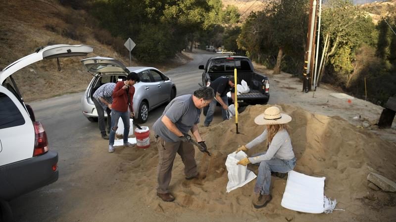
© Wally Skalij / Los Angeles TimesResidents from Kagel Canyon in the Sunland area fill sand bags at a fire station on Sunday, before a storm hits the areas burned in the Creek fire. In Santa Barbara County burn areas, evacuations are underway.
The first major rainstorm in nearly a year moved into Southern California on Monday, bringing light showers that will intensify in the afternoon.

The rain is of greatest concern in areas burned in the massive Thomas Fire, where officials said mudslides are possible.

Authorities have ordered evacuations of Santa Barbara County neighborhoods that sit below areas recently burned by wildfires.

Cloud Precipitation

Heavy rain, floods and landslides leave at least 37 dead in Kinshasa, Democratic Republic of the Congo

Flooding in Kinshasa
Heavy rain from 03 January has caused flooding and landslides in and around the city of Kinshasa, capital of the Democratic Republic of the Congo.

At least 37 people are thought to have died, and it is feared that this figure could rise as further assessments are carried out.

Local media said that the fatalities occurred in several areas around the city, including in Ngaliema, Selembao, Bandalungwa, Limete and Barumbu.

The provincial minister for health and social affairs, Dominique Weloli, told AFP that the district of Ngaliema, a poor hillside community, was particularly hit. Other affected areas include Kingabwa, Mombele and Ndjili.


Cloud Precipitation

Cyclone Ava causes floods and landslides in Madagascar, 6 dead and 15,000 displaced

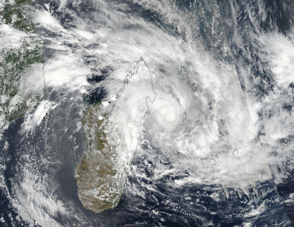
On Jan. 4 at 5:42 a.m. EST (10:42 UTC) NASA-NOAA’s Suomi NPP satellite captured this visible image of Tropical Cyclone Ava just off shore of northeastern Madagascar.
© NOAA/NASA Goddard Rapid Response TeamOn Jan. 4 at 5:42 a.m. EST (10:42 UTC) NASA-NOAA’s Suomi NPP satellite captured this visible image of Tropical Cyclone Ava just off shore of northeastern Madagascar.
Tropical Cyclone Ava swept across Madagascar from 05 January 2018, bringing with it strong winds and heavy rainfall that has caused flooding and landslides.

According to reports from the Bureau National de Gestion des Risques et des Catastrophes (BNGRC) in Madagascar, at least 6 people have died and over 15,000 displaced.

Among the worst hit areas are the capital Antananarivo, where at the peak of the storm over 3,200 people were forced from their homes to safer locations. Many areas of Antananarivo are at risk of landslides after heavy rain. As of 08 January, Red Alerts were in place for landslides in several districts of the city.


Tornado1

Tornado rips through 2 towns in French Pyrenees (UPDATE)

Tornado SW France Jan 2018
A tornado touched down in in St.-Jean-Pla-de-Corts, Pyrenees Orientales, SW France this morning, January 7th. Tornadoes in France, and most of Western Europe, are historically rare, although in recent years the twisters have become much more commonplace.

Comment: Update - Mon, 8th January:

RT reports that two local communities in the French Pyrenees have suffered massive damage after the tornado left a trail of destruction in its wake. Inhabitants of the picturesque commune of Maureillas-las-Illas in the Pyrenees-Orientales woke up to the sounds of destruction Sunday morning after the tornado fell on the town shortly before 9 o'clock.

The strong winds caused massive damage, destroying the roofs of about fifty houses. Several trees were knocked to the ground and power has been affected. The local nursery school was also hit and will remain closed Monday.

The tornado then moved a little further north to the town of Fourques. There, the twister struck some 24 dwellings. A man was slightly injured but was immediately treated by the rescue team. Electricity to some 50 homes was restored by the evening.


Some other rare tornadoes have formed around the planet in recent times including countries such as Turkey, Netherlands, Mexico, United States, Russia and China.

Study: Tornado outbreaks are increasing - but scientists don't understand why. A coauthor of this paper states "What's pushing this rise in extreme outbreaks is far from obvious in the present state of climate science."

Recently other climate scientists were saying hurricane Harvey "should serve as a warning", as they continue to push the man-made climate change/global warming lie. They are not considering the importance of atmospheric dust loading and the winning Electric Universe model in their research. Such information and much more, are explained in the book Earth Changes and the Human Cosmic Connection by Pierre Lescaudron and Laura Knight-Jadczyk.
The accumulation of cometary dust in the Earth's atmosphere plays an important role in the increase of tornadoes, cyclones, hurricanes and their associated rainfalls, snowfalls and lightning. To understand this mechanism we must first take into account the electric nature of hurricanes, tornadoes and cyclones, which are actually manifestations of the same electric phenomenon at different scales or levels of power.
Increasing cometary and volcanic dust loading of the atmosphere (one indicator is the intensification of noctilucent clouds we are witnessing) is accentuating electric charge build-up, whereby we can expect to observe more extreme weather and planetary upheaval as well as awesome light shows and other related mysterious phenomena.


Snowflake Cold

'Bomb cyclone' hits US East Coast: 65k homes without power and rising gas prices

“bomb cyclone” New England guy snow blowing
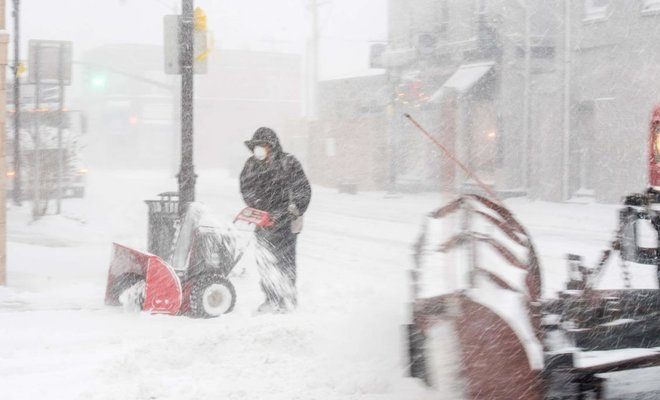
© AFPThe “bomb cyclone” was expected to dump heavy snows in New England as the storm system moved up the US east coast.
An intense winter storm froze pipes and disrupted services at refineries on the US Atlantic coast on Thursday, sending fuel prices higher as heavy snowfall and high winds caused electricity outages for tens of thousands of Americans.

Some 65,000 homes and businesses along the US East Coast are without power, and that number is expected to swell on Thursday as the storm punishes the densely populated US Northeast.

The storm is the product of a rapid and rare sharp drop in barometric pressure known as bombogenesis, or bomb cyclone. Heavy snow pounded the East Coast along a front stretching from Maine as far south as North Carolina early on Thursday, taking out power lines, icing over roadways and closing hundreds of schools.

Snowflake

Boston storm tops blizzard of 1978 for high tide

boston storm
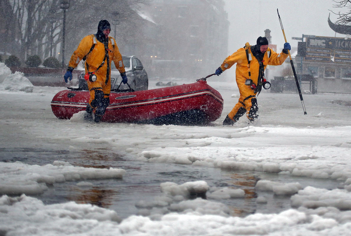
© Nancy LaneBilly Carey and Justin Plaza, at right, from Boston Fire Rescue swift water team haul their boat after saving a man from his flooded car on Commercial Wharf during the storm on Thursday,January 4, 2018.
Surging floodwaters in Boston that were spurred by yesterday's powerful winter storm can now be associated with a record high tide, according to the National Weather Service.

Boston recorded a high tide of 15.16 feet (4.88 feet above the astronomical tide), breaking the previous record of 15.1 feet that was recorded during the Blizzard of 1978.

Yesterday's high tide was the result of a chance encounter between a low-pressure system and the moon cycle timed just right, said Hayden Frank, a meteorologist at the National Weather Service in Taunton.

"We had a very high astronomical tide, which was 12.1 feet," Frank said. "That's controlled by the moon cycle. That's something you can calculate years in advance.

Comment: Bostonians are calling for a sea wall to be built at the harbor to protect (incorrectly) against the ravages of global warming:
The city's Climate Ready Boston report raised the possibility of building a sea wall, and City Councilor Lydia Edwards - whose district includes waterfront-heavy Charlestown, East Boston and the North End - said it's not a far-fetched idea.

"Nothing is off the table in terms of what we need to look at," Edwards said, adding that a sea wall would be a "short-term" response compared to long-term efforts to reduce greenhouse gas consumption and slow global warming.

"I don't think we needed this (the storm) to say we need to look at this seriously; this is a continued reminder that we cannot kick the can - this is directly impacting us right now," said Edwards.

She is also supporting more sustainable development on the waterfront.

But constructing a sea wall is a costly and complicated prospect - with one estimate putting the bill at $10 billion.

Such a barrier would run from the tip of Logan International Airport to South Boston. A more ambitious wall being eyed would encompass the Harbor Islands or stretch as far out as the coast of Hull.
This record high tide is being attributed by some to the recent supermoon:
Benjamin Sipprell, a meteorologist in Boston for the National Oceanic Atmospheric Administration, told the Daily Beast that the flooding was a result of the blizzard hitting at high tide, and the high tide being higher than usual due to Wednesday's supermoon.

A supermoon is a full moon that occurs when the moon is closest to Earth in its orbit. This happens about four to six times a year.

The tides are caused by the moon's orbit, and are at their highest during full moons. Supermoons bring them even higher.

'Normal tides in Boston are between 9 and 10 feet,' Sipprell explained. 'When we get tides, we get some that go up to 12 feet or more. We were forecasting 12.1 feet with this one, but with the surge, it got bumped up to 15 feet.

'It's definitely historic.'


Snowflake Cold

A taste of the future: Fruit and vegetable prices surge as blizzards cut off roads, damage crops in China

snow damage
Fruit and vegetable prices in major cities in central and northern China have surged after severe winter weather cut off highways and damaged crops, the government said late on Saturday.

Parts of highways connecting Henan, Shanxi, Shandong, Anhui and Jiangsu provinces were blocked. In northern Shanxi province, greenhouses for vegetables collapsed under the weight of snow, footage on state television showed on Sunday.

"More than 45,000 acres of fruit trees, tea farms as well as greenhouses for vegetable have been damaged by freezing rains and snow," the Ministry of Agriculture said, adding that wheat planting could be delayed due to the cold weather.

Cloud Lightning

Thunderstorms hit eastern Spain resulting in torrential downpours, hail and tornadoes

Thunderstorm in Spain
As expected thunderstorms hit eastern Spain this afternoon. An impressively unstable environment, particularly for January, established along the frontal system ahead of the forming cutoff upper low.

Snowflake

'Bomb cyclone' leaves frozen wake of destruction and kills 22 in eastern US

people in snow
© Mike SegarManhattan, New York January 4, 2018.
The 'bomb cyclone' cold weather system that hit the US east coast this week has moved on, leaving freezing temperatures and more than 20 dead in its wake.

At least 22 people have died as a result of the extreme conditions, CBS News reports. The casualties include a girl who was hit with a pickup truck whilst sledding in Richmond, Virginia, and a man who was killed by a snow plow, also in Virginia.

The National Weather Service said the "arctic airmass [is] to remain entrenched over the eastern US this weekend."

"Bitterly cold temperatures and dangerous wind chills are likely over the eastern third of the country this weekend," it warned.

Comment: Chicago hasn't seen a cold snap this long (12 days) since 1936 and 1895 before that, with areas reaching 21 degrees Fahrenheit below zero. There's a wind chill warning for the rest of the weekend in the northeast, where temps may drop as low as 45 below with the wind chill:
Daily record lows within reach Sunday morning include (record to beat is shown): Boston (2 degrees below zero); Providence (1 degree below zero); New York City (4 degrees); Philadelphia (4 degrees).

If Philadelphia slips below zero on Sunday morning it would be the first subzero low temperature in the city since 1994.

New York City could record just its second subzero low temperature since 1994 on Sunday morning. The last time the Big Apple was below zero was on Valentine's Day in 2016

Some relief from the cold will arrive in the Midwest on Sunday as temperatures rise to near or above average in most locations. This return to near-average temperatures will sweep into the Northeast by early next week.
The past 2 weeks have seen daily record lows in the area.