Storms
S


Cloud Precipitation

Acute hailstorm slams Moncalieri in Italy

hail
Severe hail storm hits Moncalieri, Torino - ITALY June 7, 2020.


Cloud Lightning

9 killed by lightning strikes in Odisha, India

lightning
As many as nine people were killed after being struck by lightning in different places of Odisha on Monday.

According to reports, two women were killed in Raidihi and Dandaragari villages Dhenkanal district. Lightning struck them while they were sitting on the veranda.

Likewise, a minor boy was killed at Majhiguda village under Papadahandi block of Nabarangpur district.

Moreover, one each persons were killed at Birsa Munda Playground in Anandapur of Keonjhar district, Baradanga village under Mahakalapada in Kendrapara district, Baragudipada village in Jagatsinghpur, Mohana in Gajapati, Bhanjanagar in Ganjam district and Cuttack district.

Snowflake

June snow for Montana, Idaho brings up to a FOOT of powder to northern Rockies

Snow falls along Interstate 15 near Elk Park, Montana on June 8, 2020
© Montana DOTSnow falls along Interstate 15 near Elk Park, Montana on June 8, 2020
The summer solstice is just under two weeks away, and yet parts of the northern Rockies resemble a scene out of winter on Monday.

The National Weather Service (NWS) Weather Prediction Center (WPC) said heavy snow has developed across parts of Idaho and Montana.

The NWS office in Missoula said a band of moderate to heavy snow developed along the Interstate 90 corridor from Deer Lodge to Butte, bringing several inches to the region.

Forecasters said an "anomalously cold and vigorous upper trough for early June," is swinging through the western U.S and northern Plains, bringing the threat for severe weather.


Tornado2

Tornado hits Kaniów, Poland

tornado
Tornado hits Kaniów, Bielsko Biala region - Poland, June 7, 2020.


Tornado2

Tornado filmed in Ciudad Madero, Mexico

tornado
Tornado in Ciudad Madero, Tamaulipas - Mexico, June 5, 2020.


Snowflake

June storm dumps 7 inches of snow in 24 hours on Bogus Basin, Idaho - more in store as it tracks over region

Bogus picks up 7
Bogus picks up 7" of snowfall, more in store today as core of storm tracks over region
Say it ain't snow?!?! This soggy June storm is dumping snow on our higher elevations.

Bogus Basin picked up 7 inches over the past 24 hours and is expected to see another 6-10 inches over the next 24 hours.

The last time Bogus saw this much snow this late in the season was back on May 22, 2010 when the mountain saw over 16"!

While Long Valley has so far reported around 2" in accumulations as snow levels have dropped to 5,500ft this morning.

Comment: Nearby at Tamarack up to 10 inches of snow has been reported:


Windsock

Tens of thousands without power after rare derecho hits Wyoming and Colorado

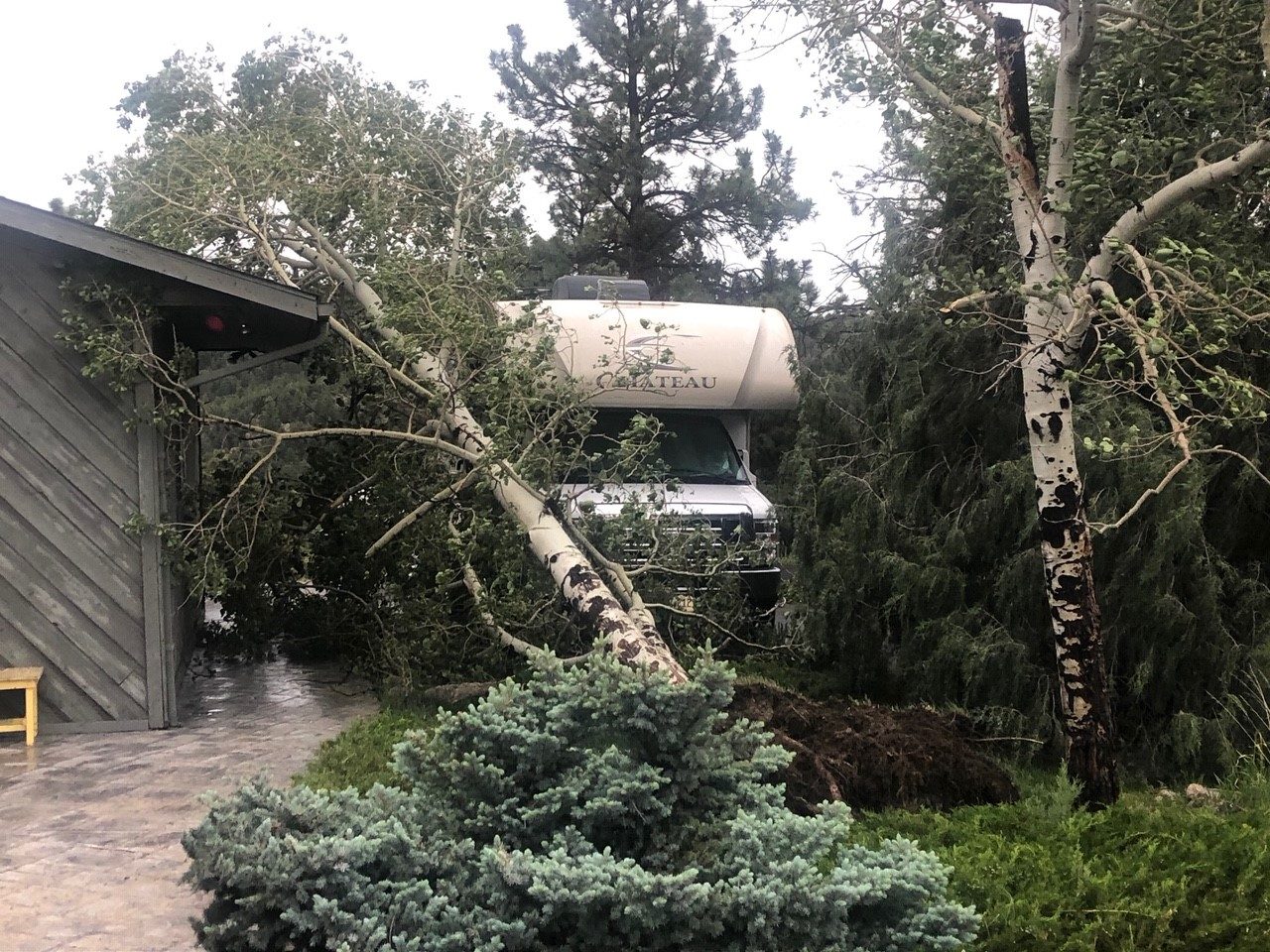
Tree damage in Evergreen from Saturday’s derecho
© Jennifer DicksonTree damage in Evergreen from Saturday’s derecho.
A derecho packing winds in excess of 75 mph moved across Wyoming and Colorado Saturday, damaging homes and knocking down trees and power lines.

The storms produced several hurricane-force wind gusts, including a 110 mph gust in Winter Park, Colorado, according to the National Weather Service. Winds up to 99 mph were reported in Great Divide, Colorado, and 81 mph in Rock Springs, Wyoming. A 78 mph wind gust was reported at Denver International Airport.

Enough significant wind gusts were recorded on Saturday that a record was set for most significant wind gusts in one calendar day.

The derecho, a strong line of thunderstorms that produces hundreds of miles of straight-line wind damage, developed in far eastern Utah Saturday morning, then raced northeastward across Colorado and Wyoming into the western Dakotas and western Nebraska during the afternoon and evening hours, a track of at least 750 miles in about 12 hours, according to Elizabeth Leitman, a meteorologist with NOAA's Storm Prediction Center.

The line of storms formed on the southern flank of a developing low pressure system over the northern Rockies and southwestern Canada.


Comment: Another rare derecho killed three and cut power to half a million people across Pennsylvania and New Jersey last Wednesday.


Attention

Adapt 2030 Ice Age Report: Who gets what when supply chains breakdown

UK food pickers wanted
© YouTube/Adapt 2030 (screen capture)
Decisions need to be made when there are not enough resources to go around through the shrinking supply chain. Labor shortages and unharvested crops mean out of season crops will not be available leading to a "hunger gap" of seasonal availability. Tunisia on par to smash record crop yields in 2020 with a history of asset bubbles.


Comment: The coronavirus crisis, in addition to earth changes affecting crop growth, and the losing value of currency which is set to get much worse in Western nations in particular, have made the production, availability, purchasing and distribution of food - a MAJOR global issue the likes of which we haven't seen in generations.

See related articles:


Cloud Precipitation

Severe hailstorm damages cars, agricultural goods and kills birds in Morocco's Fez-Meknes region

hailstorm
Videos and photos have gone viral online showing a heavy hailstorm hitting the Fez-Meknes region over the weekend.

One of the videos shows hailstones covering the green grass of a resident's backyard.

Other photos submitted to Morocco World News show hailstones all over the region's roads.

Youssef Belhaissi, a journalist for Morocco's Medi1 TV channel, also shared photos showing the damages the hailstorm inflicted upon the city.


Tornado1

Storm Cristobal: Tornado hits Florida as US Gulf Coast braces for battering from tropical rains

The storm has already wreaked havoc in Mexico
© REUTERSThe storm has already wreaked havoc in Mexico
The US Gulf coast is bracing to be battered by a powerful tropical storm and tornados.

Rain pounded the region on Sunday ahead of the arrival of Tropical Storm Cristobal, which has already spawned a tornado in Florida and threatened more twisters along with high winds and storm surge.

Roads flooded in coastal Louisiana and Mississippi, and thousands were without power even before the storm made landfall.

Forecasters warned the storm would affect a wide area stretching roughly 180 miles (290 kilometres) east into Florida and would arrive late on Sunday, but they do not expect it to grow into a hurricane.