Earth ChangesS


Stop

Japan Tsunami Broke Off Antarctica Icebergs Twice the Size of Manhattan

Image
© NASA/handoutThick cloud cover briefly fell away to reveal this first image of icebergs breaking away from the Sulzberger Ice Shelf due to sea swell from the Tohoku Tsunami, which had originated 8,000 miles away about 18 hours earlier. The icebergs can be seen behind a thin layer of clouds just off the ice shelf near the center of the image
The tsunami generated by the powerful earthquake that shook Japan on March 11 sent waves an entire hemisphere away that sliced off about 50 square miles of icebergs in Antarctica that were twice the surface area of Manhattan, NASA scientists say.

Kelly Brunt, a cryosphere specialist at Goddard Space Flight Center, and her colleagues were able to link the calving of icebergs from the Sulzberger Ice Shelf in Antarctica following tsunami that sent waves 8,100 miles away.

The finding is presented in details in a paper published in the Journal of Glaciology. It is the first direct observation of its kind, said NASA.

Japan's powerful magnitude-9.0 earthquake killed more than 20,000 people and caused more than $230 billion in damages, according to the World Bank. The tsunami also damaged the Fukushima Daiichi nuclear power plant in Fukushima prefecture, making it the worst nuclear disaster since Chernobyl in 1986 in Ukraine.

Attention

Strong 6.0 Magnitude Earthquake Hits Philippine Island of Dalupiri, No Damage Reported

Image
© Google Maps
A strong earthquake struck the Philippine island of Dalupiri on late Thursday morning, seismologists said, but there were no immediate reports of damage or casualties.

The 6.0-magnitude earthquake at 10.56 a.m. local time (0256 GMT) was centered less than a kilometer (mile) from the western coast of Dalupiri Island, which is part of the Babuyan Islands in the Luzon Strait north of Luzon island in the Philippines. It struck about 113 kilometers (70 miles) deep, making it an earthquake of intermediate depth, according to the Philippine Institute of Volcanology and Seismology (PHIVOLCS).

There were no immediate reports of damage or casualties from the area, which is mostly uninhabited. The United States Geological Survey (USGS) measured the earthquake at only 5.4 on the Richter scale but at a much shallower depth of just 20 kilometers (12 miles).

The Philippines is on the so-called 'Pacific Ring of Fire', an arc of fault lines circling the Pacific Basin which is prone to frequent and large earthquakes. Volcanic eruptions also occur frequently in the region.

Radar

4.1 Magnitude Earthquake Recorded Near US-Mexico Border

Image
© Epicentre. Image Google Maps
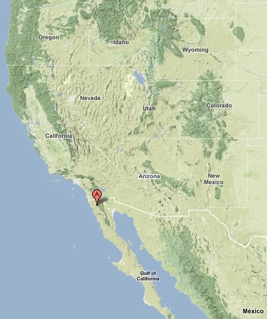
A magnitude 4.1 struck close to Baja California's (Mexico) border with the U.S. state of California on Tuesday evening, according to the US Geological Survey (USGS).

The quake hit 40 kilometres from the border and was centred 34 km (21 miles) NE (44°) from Ensenada, 45 km (28 miles) NNE (25°) from Maneadero, 59 km (36 miles) SSE (155°) from Tecate, and 78 km (49 miles) SE (128°) from Tijuana (all Baja California, Mexico).

The earthquake was recorded at a shallow depth of 11.3 km (7.0 miles). It was followed six hours later by a magnitude 2.6 earth tremor.

USGS information on earthquake HERE

Bizarro Earth

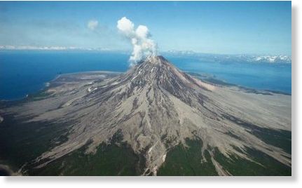
Aleutian Islands: Cleveland volcano erupts

cleveland volcano
Cleveland Volcano, located on uninhabited Chuginadak Island in the Aleutians, has begun building a lava dome. An Alaska volcano has begun erupting, but it is not yet posing a serious hazard to populations or aviation in the region.

The eruption was described as a "slow effusion of magma that is forming a lava dome" by John Power, the scientist-in-charge at the Alaska Volcano Observatory.

Along with the quiet nature of the eruption, the remote siting of the volcano has so far kept the hazard level low.

Bizarro Earth

Indonesia: Mt. Ibu Emits Thick Smoke

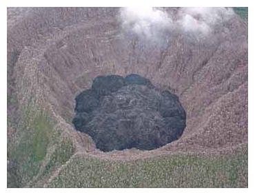
Mt Ibu
© Bruce Gemmell, PT Nusa Halmahera MineralsA closer look at the lava dome within the Mt. Ibu crater. May 2000 photograph.
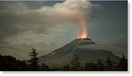
Mt. Ibu in West Halmahera regency has been emitting thick smoke, causing its alarm status to be raised on Sunday.

Ridwan, a volcanic observer at Mt. Ibu said the mountain's activities had intensified over the past two weeks. Hundreds of small eruptions have been recorded by the seismograph. "There were numerous tremors. Therefore we increased its status to alert level II," he said yesterday.

Ridwan said the mountain had been closed to hikers and people were prohibited from getting within 3 kilometers of Mt Ibu's crater. "We announced this two weeks ago and have intensified our observations. We hope people will be aware," he said.

Bizarro Earth

Activity at Kizimen and Shiveluch volcanoes, Kamchatka Peninsula

kizimen, volcano
The Kamchatka Peninsula, along Russia's Pacific coast, is currently the most volcanically active area in the world: four volcanoes are erupting simultaneously, and a fifth is showing signs of an impending eruption. Ash plumes from two of these volcanoes and a thermal anomaly marking active lava flow at a third are visible in this natural-color satellite image.

Along the northern (top) edge of the image Shiveluch emits a broad gray plume from the lava dome growing on its southern flank. 90 kilometers (60 miles) to the southwest a much smaller plume escapes from Bezymianny. Further south, an area where the instrument measured high temperatures over land is outlined in red, marking Kizimen.

Cloud Lightning

Russia: Ball lightning strikes German tourist bus near Kaliningrad

Image
© Unknown
Ball lightning struck a bus with German tourists near Russia's western city of Kaliningrad, chairwoman of the regional tourist association Tamara Toropova said on Thursday.

None of the 19 passengers on board the bus was injured when the ball lightning struck the bus during a thunderstorm on Monday.

Bizarro Earth

Australia: Victoria - Floods Inundate Gippsland Farms, Close Roads

Image
© Wayne TaylorFollowing heavy rainfall the Thomson Dam is 46.3 per cent full, it's highest level in almost six years.

Extremely heavy rainfall this week in eastern Victoria has caused widespread flooding of Gippsland farms, closed local roads and threatens to affect townships in low-lying areas as rivers swell.

But the rainfall has been a boon for the Thomson Dam where 85 millimetres fell in 24 hours, pushing the dam to 46.3 per cent full, its highest level in almost six years.

Seven locations in Gippsland and East Gippsland received more than 100 millimetres of rain in the 24 hours to 9am yesterday, with Reeves Knob recording the highest total, a massive 137 millimetres.

Late yesterday major flood warnings were in place for the Mitchell and Thomson rivers and moderate warnings for the Avon, Latrobe and Macalister rivers. Widespread flooding has occurred on farmland at Cowwarr, Denison, Nambrok and Lindenow, but no homes have been inundated.

Cloud Lightning

Extreme Weather Affects Most Of The US

sun/dry earth
© n/a
Weather records are being broken in many regions of the US.

According to NOAA's National Climatic Data Center, 41 of the lower 48 states had above-normal or a record warmest July. Only seven of the lower 48 states - all west of the Rockies - experienced a July average temperature near or below the twentieth century average.

Drought conditions are so bad in Texas, covering 75 percent of the state, that it would take about 20 inches of precipitation in one month to end the drought. According to the weather service, Texas has suffered its warmest June and July on record, going back to 1895. The city of Dallas is on track for setting the record for having 43 consecutive days of temperatures above 100 degrees.

The record heat is also affecting smaller communities. In Kemp, Texas, residents are suffering from no water in the midst of the record heat. City officials made the decision to shut off the municipal water supply.

Cow Skull

Earth's Surface 'Recycled' Surprisingly Quickly

Volcanic Islands
© NASAThe volcanic islands of Hawaii are thought to be fueled by a plume of hot rock that moves upward from the lower portions of the Earth's mantle.

The ground we stand on seems permanent and unchanging, but the rocks that make up Earth's crust are actually subject to a cycle of birth and death that changes our planet's surface over eons. Now scientists have found evidence that this cycle is quicker than thought: 500 million years instead of 2 billion.

The tectonic plates that make up Earth's crust are constantly jostling against each other: brushing past one another in some places, moving apart in other areas, and butting head-on in still other places.

Where these head-on collisions occur, denser oceanic crust is shoved beneath lighter continental crust, causing it to melt in the ferocious temperatures and pressures of Earth's mantle. This oceanic crust gets mixed into the rest of the mantle, which because of its high temperature and pressure slowly flows and fuels the world's volcanoes.

Virtually all of the world's ocean islands are volcanoes. Several of them, such as the Hawaiian Islands, came from mantle plumes originating in the lowest part of the mantle. This geological process is similar to the movement of a Lava Lamp: hot rock that used to be part of the oceanic crust rises in cylindrical columns from a depth of nearly 1,900 miles (3,000 kilometers). Near the surface, where the pressure on it is reduced, the rock melts and forms volcanoes.

Scientists had thought this process took about 2 billion years to complete, but new data suggest it could have happened in a quarter of that time.