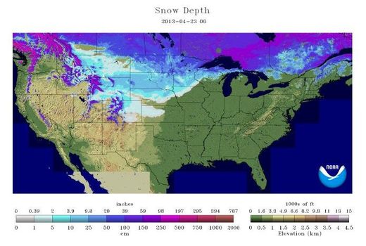
© NOAASnow depths on April 23, 2013.
Spring has gotten off to a colder- and snowier-than-average start in parts of the United States, particularly in the eastern Rockies and Upper Midwest.
Duluth, Minn., for example, has seen 51 inches (130 centimeters) of snow this April.
That's not only the most snow the town has seen in any April - breaking the old mark of 31.6 inches (80 cm) - but the most snow the town has received in any month, ever, according to government records. As of Monday (April 22), a total of 995
snowfall records have also been broken so far this month, according to AccuWeather. Over the same time period last year, 195 snowfall records had been broken.
More than 91 percent of the upper Midwest also has snow on the ground as of today (April 24), meteorologist Jason Samenow wrote
at the Washington Post's Capital Weather Gang blog.
"Snow cover in the previous 10 years on this date hasn't even come close to reaching this extent (ranging from 19 percent to much lower)," he wrote.
So why has spring failed to take hold? Blame the jet stream.
The record snow and below-average cold is due to a trough or dip in
the jet stream, which has brought blasts of freezing air as far south as the Mexican border, said Jeff Weber, a scientist with the University Corporation for Atmospheric Research in Boulder, Colo.
Whence the snow? This dip in the jet stream has also brought moisture from the Pacific to the Eastern Rockies. Boulder, Colo., for example, saw
47 inches (119 cm) of snow in April, breaking the old record of 44 inches (112 cm).From the dip, the jet stream then swoops up to the north toward Minnesota, bringing new moisture with it from the Gulf of Mexico, Weber said. That has made for snowy conditions throughout the region.
This persistent trough has largely stayed in place during much of April, due in part to a stubborn mass of warm air over Greenland and the North Atlantic, Weber said. A similar system was also responsible for the
record cold seen in March throughout much of the Eastern United States.
This mass of air has blocked the normal eastward progression of the jet stream, which normally brings warm air from the south and west into the central United States. Instead, this "buckled" jet stream has been stuck in place, bathing the Rockies and Upper Midwest in cold, and often moist, air, Weber said.
Warming upBut now, the mass of warm air over the North Atlantic is finally dissipating, and higher temperatures are expected by this weekend from Colorado to Minnesota, Weber said. While temperatures have recently dipped into the single digits (below 10 degrees Fahrenheit, or minus 12 degrees Celsius), they should reach above 80 F (27 C) by the weekend throughout much of this region, he said. [
6 Signs that Spring Has Sprung]
This will lead to a lot of melted snow, which could cause some of the worst flooding ever seen in the Upper Midwest, Weber said.The persistent cold has helped tamped down severe weather and tornadoes, which thrive on the interaction of warm, moist air with cold, dry air, Weber said. However, he expects to see a lot more severe weather and tornadoes in the near future, particularly in the Southeast.

Reader Comments
to our Newsletter