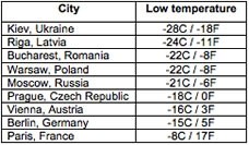
The brutal cold has killed at least 163 people in central and eastern Europe, many of them homeless. In Ukraine, where the death toll now stands at 101, nearly one thousand people have been hospitalized due to frostbite and hypothermia. Temperatures in some parts of the country dropped as low as -33ºC (-27ºF) on Thursday.

Elsewhere in Eastern Europe, the cold has been just as unforgiving. Parts of the Black Sea froze along the coastline of Romania, where an intensifying low-pressure system dumped several feet of snow in the Romanian capital of Bucharest. In neighboring Bulgaria, 16 towns recorded their all-time lowest temperatures since records began a century ago.
While the core of the arctic air has been centered over eastern Europe, few parts of the continent have escaped winter's icy grip. In Italy, forecasters have called it the coldest week in 27 years, as widespread snow disrupted transportation across the northern and central part of the country. (AccuWeather reports heavy snow in Rome this morning) Snow even fell as far south as the Mediterranean island of Corsica, where some locations recorded over 20 cm (8 inches).
Farther north, canals have lent themselves to ice skating in the Netherlands, and in northern Germany, the Elbe River has started to freeze over.
What's causing the extreme cold?
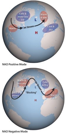
Behind Europe's cold wave is a dip in the jet stream that has allowed a large area of high pressure to move westward out of Siberia. Normally, Europe experiences fairly temperate weather for its latitude because the predominant airflow (from west to east) carries mild maritime air from the Atlantic Ocean towards the continent. This typical west-to-east flow pattern results from a strong pressure difference between the Icelandic low and the subtropical Azores high (see top right image).
Occasionally, these two pressure systems weaken simultaneously, allowing a dome of cold Siberian air to drift westward into Europe and North America (bottom right image).

How long will the cold last?
Frigid conditions are expected to remain in place into early next week, with the core of the cold parked over Western Europe this weekend. The UK Met Office is forecasting possible snow showers in the eastern UK as a low pressure system arrives from the west. In central and eastern Europe, temperatures have slowly begun to rise, but will stay below freezing, some 5-10ºC below average.


Reader Comments
to our Newsletter