© MPR Photo/Ann Arbor Miller
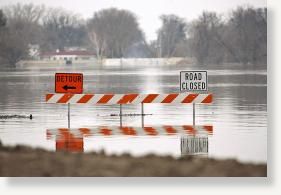
A stretch of Interstate Hwy. 29 will remain closed indefinitely north of Fargo, where overland floodwaters are running 8 inches deep across its driving lanes.
North Dakota Gov. John Dalrymple, in Fargo during the continuing flood emergency, said it would remain closed indefinitely. The highway is closed between Fargo and Hillsboro, nearly 40 miles to the north.
Dalrymple and other officials indicated that the flood crisis had moved from Fargo and Moorhead, where the Red River crested Saturday, to outlying areas to the north, downstream. Several people were evacuated from rural homes over the weekend and emergency agencies remained on alert for more Monday.
The high water in the Red has been preventing tributaries from draining into it, forcing them to run across the flat countryside.
One of those tributaries is the Wild Rice River in Hendrum, Minn., where the U.S. Army Corps of Engineers said Monday that it's adding 2 feet to some sections of levees. Roads are being closed in the town north of Fargo as well, the corps added.
The Wild Rice is currently at 32.65 feet and "rising quickly," the corps said. Local officials requested the higher levees as a crest is anticipated by Thursday, according to the National Weather Service.
Fargo recorded 0.73 inches of rain Sunday. That did not raise the river, but it's expected to keep it high through the week. National Weather Service forecaster Jim Scarlett said the river might drop fewer than 3 feet from its crest by Sunday.
For Fargo-Moorhead it was the fourth highest crest in history, after a record in 2009 and a peak in 2010 that will now rank as seventh highest.
Fargo spent between $6 million and $8 million preparing for this year's flood and again relied on work from thousands of volunteers. Dodging a calamity again prompted Mayor Dennis Walaker to emphasize Monday the need for a planned $1.7 billion flood diversion project.
"One of these days we're going to lose," he said. "We need to keep moving this thing forward. Three floods in a row - they're sick of sandbagging."
In Stillwater, the St. Croix River rose past flood stage at about 10 a.m. Sunday, topping 87 feet. The gauge was expected to slowly top out at 87.8 feet by Tuesday afternoon, according to the National Weather Service, then linger there awhile before easing back down to 87 feet by next Monday.
It was not expected to move beyond the minor flooding stage. That is an improvement from Saturday's forecast, which said the river would hit 88.6 feet by Thursday.
It also means it will still likely be a long week for commuters who rely on the Stillwater Lift Bridge, who began using detours last Friday when it was ordered closed because of the rising water.
Likewise, the Mississippi River at St. Paul appeared to top out on Sunday morning at 18.7 feet, and will linger there until beginning a gradual descent by Wednesday, the Weather Service predicts. Cities downriver were only expecting minor to moderate flooding.
Rain, however, is in the forecast for the end of the week, and may affect those predictions.

Reader Comments
to our Newsletter