A day after wind gusts of over 60 mph Thursday, Western Washington was "treated" to a second round of storms Friday.
A large cool of very cold, unstable air moved into the region Friday, lighting up the radar with widespread showers that brought heavy rain, large hail, and frequent lightning across the Puget Sound area -- thunderstorms that were certainly big by Northwest standards.
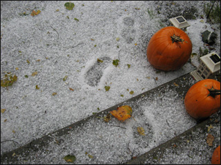
|
| ©K. McAlpine |
Most reports were of marble to pea-sized hail, but one particularly strong storm around 9 o'clock brought nickel-sized hail near Eatonville, and 3/4" size hail to Rainier. The large hail sparked a rare Severe Thunderstorm Warning for the area that lasted until 9:30 p.m.
That storm passed off to the north and east, but there were plenty more where that came from. Another wave of strong showers and thunderstorms was moving through the central Puget Sound area round 10 o'clock.
The rain is coming on the heels of the big wind Thursday that knocked countless leaves off area trees, and those were clogging drains and causing localized urban flooding.
Typically, the storms fizzle after sunset and we lose the sun's heating. But the air is so unstable, thunderstorms are expected to continue to form and move around overnight.
What Makes Air Unstable?
So, why are we getting thunderstorms? It all hinges on getting unstable air.
The most common way in the Northwest for air to become unstable is to have a cold air mass move into the upper levels of the lower atmosphere. In a nutshell, warm air rises until it gets as cold as the surrounding air. If the air is colder aloft, that warm air can rise father until it gets to that point. As air rises more and more, you get bigger clouds and stronger storm development.
But basically, any time we get really cold air moving in -- at least relative to what it was before -- the air can become unstable. In this instance, the air moving in aloft is much colder than what was here before, and that's why these thunderstorms are pretty strong. We also have some decent mid-level winds and mix that with our mountainous topography, and the mountains can provide extra lift for even better thunderstorm development.
(That also helps explain why thunderstorms are rare here and when we do get them, they're not as strong as the Midwest. The ocean is a constant 50-55 degrees year round, so it has a modifying effect on the air masses. So we don't get the big temperature swings like the Midwest can, when they get the battle between the hot, humid weather from the south and the cold, dry arctic air from Canada mixing together.)
Thunderstorms are still in the forecast through Saturday, and then should fizzle Saturday evening as the air mass finally moderates and the atmosphere stabilizes again.


Reader Comments
to our Newsletter