|
| ©BeachConnection.net |
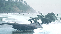
| Surreal stumps of Neskowin |
If truth is really stranger than fiction, then the oddities cropping up all over the Oregon coast make Stephen King and Arthur C. Clarke look like kids weaving silly tales in their tree forts. Extremely old tree stumps - anywhere from 300 years old to 2,000 years old - are being unearthed by unbelievably low sand levels this winter, caused by big storm action. But one group of stumps showing up are shockingly old - to the tune of 80,000 years old.
These remnants of ancient forests popping up at Hug Point and Arch Cape, near Cannon Beach, are really ancient, according to Seaside, Oregon, resident Tom Horning, a geologist with the Coastal Natural History Center in Seaside. Theories vary on their origins, with explanations differing on each locale, but it's agreed they are remarkably preserved because some sudden, perhaps even abrupt, catastrophic event buried them fairly quickly in sediment, sand or sea water. If left out in the air, these ancient forests would have decayed as any other wooden object.
"They are part of a forest that grew at the base of the cliffs 80,000 years ago, around the time that sea levels began to withdraw as the Wisconsinian glacial epoch began," Horning said. "Or possibly sometime near the beginning of the 8000-year warm period that preceded the glaciation. We know that many Pleistocene forests have been entombed beneath gravels at the mouths of creeks from Ecola Park to Neahkahnie Mountain."
In Neskowin - where they've been nicknamed the "ghost forest" - the stumps have been dated to be around 2,000 years old, and they have been visible about half the time at the tide line since the 90's. The two most popular theories about their origin center around a sudden, massive quake so powerful it dropped this forest as far as 25 feet, and/or a tsunami came in and lopped off the tops - either immediately after this big event, or perhaps down the road, such as the big tsunami that hit here in 1700.
That same tsunami is largely credited with having created the recently uncovered stumps and root systems at Moolack Beach in Newport, although some camps argue this forest also met its demise because of a sudden drop in the soil.
While two of the Oregon coast's more prominent geology experts, Roger Hart and Guy DiTorrice, tend to lean towards those explanations, Horning isn't so sure. He believes that's possible, but believes something a little less sudden was likely the culprit, like the area getting filled up by water or soil over a matter of years because of a change in geography.
He added there are more ancient forests buried under 50 feet of sediment about a mile north of Hug Point, and other surprises are to be found in the area, especially now.
"Usually, the Hug Point stumps are buried beneath the sands of our modern beaches, and so are rarely seen," Horning said. "Of interest, there are stumps exposed near sea level, both at Arcadia Beach and Arch Cape, suggesting that not only was there a great forest of spruce and cedar growing along the shore at the same time, but that it was entombed and preserved around the same time, perhaps by a common process. Possibly, the mechanism by which it was entombed was from a great earthquake which dropped the land several feet, sinking the forest into the marshes, where the stumps of the trees were preserved beneath the water. However, the forests do not appear to have re-colonized so thoroughly, so maybe rapidly changing sediment conditions caused the entombment."
Staff at the Seaside Aquarium were out exploring Hug Point along with Horning recently. The aquarium's Tiffany Boothe said there were about ten of the stumps visible, though Horning points to more.
"The stumps at Hug Point are numerous," Horning said. "The trees are up to several hundred years in age. They have wide growth rings, indicating ideal growing conditions at the time. They extend to within 60 feet of the cliffs, and perhaps with more storm action this winter we will see more of them closer."
Horning said somewhere after their initial submersion they were buried under 50 feet of stuff. He said local drilling for water wells in places like Arcadia Beach has uncovered a Pleistocene-era beach some 14 feet below sea level.
The ancient prehistory of Hug Point gets even stranger the further you go back in time, according to Horning. The intricate and even weird cliffs visible now at the state park were once buried beneath all sorts of sediment, and were under layers of a terrace and shoreline that stretched miles away out to sea.
"Most likely, the terrace surface extended thousands of yards to many miles to the west, but the ocean has eroded it away," Horning said. "This erosion took place after the most recent ice age peaked around 18,000 years ago. At that time, sea level was nearly 375 ft below its present level, and the shoreline was approximately 20 miles west of Hug Point."
Beneath the sea, there is still evidence of some of this landscape, Horning said. "There are even sea stacks that look just like Haystack Rock, surrounded by rounded boulders."
After the ice age, the seas rose quickly, bringing up the shoreline and eroding things much faster, ending the lives of interesting structures we can only now guess at on these prehistoric parts of the Oregon coast.
For the last 4,000 years, this beach has been eroding, with the cliffs themselves only losing about 40 of 50 feet since they were exhumed from the debris that formed the terrace they were underneath. "So, the next time you visit Hug Point, look upon it as a cliff that has been given a second chance to see the sun and these strange new critters that walk on two legs that it didn't see the last time the ocean washed at its toe."
The erosion lasted long enough to interrupt the lives of ancient native tribes. "Early Americans who had villages near the mouths of rivers or along the ocean probably had to pick up and move every few years as the ocean consumed the coastal forest and their homesites, driving everything and everyone eastward across the coastal plain toward the looming mountain front, which now marks our modern shoreline," he said.
All this points to another interesting aspect of this coastline and what forms the landmarks that bring the hordes of beach tourists every year. In a way, the more things change, the more they stay the same, geologically speaking. Horning said that large events may plunge the land down a few feet, and sea levels may rise, but the land is rising on its own as well.
"If all this is accurate, the north coast is rising independently of sea level by about one foot every thousand years," Horning said. "It appears that the coast drops from one to six feet with each earthquake, but the land still rises slowly in the meantime. After the Great Alaska Earthquake in 1964, for example, the land at Kenai had dropped about six feet. It has since all been restored by uplift in only 40 years. Presumably these rates vary through time, and the same will probably happen along the coast of Oregon, after the next Big One hits - whenever that will be."
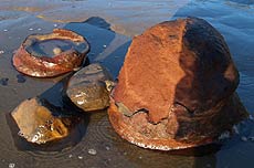
The ancient stumps aren't the only visible wonders now available for viewing by tourists and beachgoers. There are what are called "red towers" now sticking out of the sand, and odd shaped sandstone structures that resemble mushrooms a bit.
|
| ©BeachConnection.net |
| "Red Towers" made of sand cemented by iron are also found beneath the sand |
Horning said the sand towers - only a couple feet high, if that - are basically beach sand cemented by red iron oxide. They are strong enough to not be destroyed by the tough objects that batter them when just beneath the sand. "Minerals cement the sands together to form reinforced, irregular bodies within and under the beach, which are then exposed to the casual observer when the beach is washed away," Horning said. "Not uncommonly, the tops of the towers are exposed first, and rocks will wear these away, creating little pot-hole craters that make attractive landforms for photographers."
Mushroom-shaped rocks are popping up as well, their true shape revealed by the low sand levels. "These knobs of sandstone bedrock are being eroded by cobbles and pebbles on the sea floor that are swished and thrown against the bedrock during periods of strong storms," Horning said. "Similar ledges are present under the cliffs at Hug Point, formed by the same erosional process."
|
| ©BeachConnection.net |
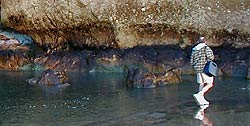
| Odd colors mark the walls of rocks normally never seen in the air |
The low sand levels have also revealed strange discolorations in the inverted terrace-like ledges beneath the cliffs. Horning said the colors come from the fact these areas are almost never exposed to air.


Reader Comments
to our Newsletter