Floods
S


Cloud Precipitation

Deadly floods strike two Australian states in wake of Cyclone Debbie

Lismore from above
© Ruby Cornish‏Lismore from above
Heavy rainfall in the wake of ex Cyclone Debbie has caused major flooding in the states of Queensland and New South Wales.

Canungra in Queensland recorded 285 mm of rain in 1 day. In New South Wales Mullumbimby recorded over 300 mm of rain in 24 hours and the Tweed River reached levels not seen for over 40 years.

Authorities have ordered over 20,000 people to evacuate their homes. Police in New South Wales have reported 2 possible flood-related deaths.


Snowflake

California snowpack is one of biggest ever recorded, now poses flood risk

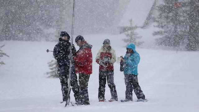
Snowpack survey in California
© Justin Sullivan/Getty ImagesFrank Gehrke, center, chief of the California Cooperative Snow Surveys Program for the Department of Water Resources, takes a sample of the Sierra snowpack near Twin Bridges, Calif.
The skies were gray, snow was falling and it was bitterly cold when state snow survey chief Frank Gehrke made his monthly march out to a deep pillow of snow in the Sierra Nevada town of Phillips on Thursday morning.

He plodded across the white mounds, plunged his metallic pole into the powder beneath him, pulled it out and made his proclamation: 94 inches deep.

The 2016-17 winter created one of the largest snowpacks in California's recorded history and it's loaded with enough water to keep reservoirs and rivers swollen for months to come.

"For recreation, there's a lot of pent-up demand for spring touring," Gehrke told reporters and viewers watching on a social media live stream. "Clearly this is going to be a good year for it. People have to be aware that conditions are different and they can't expect the same conditions they had a couple years ago."

With reservoirs and rivers already full from months of rain, the addition of melting snow will likely push water over the banks in some communities and cause flooding, said David Rizzardo, chief of snow survey and water supply forecasting for the state Department of Water Resources.

Comment: Global warming? Sierra Nevada snowpack 185% higher than normal


Cloud Precipitation

11 departments hit by heavy rain, floods and landslides in Colombia

Aftermath of the floods in Rivera, Huila, Colombia
© UNGRDAftermath of the floods in Rivera, Huila, Colombia
Colombia's National Risk Management Unit (UNGRD) says that 11 departments have been affected by severe weather events since 17 March 2017.

Overall, 55 municipalities have reported a total of 60 emergencies which have affected 1,396 families and left 12 people dead. The emergencies mostly include floods, heavy rain and landslides, but also thunderstorms and wind damage. Around 22 homes have been destroyed and another 565 have been affected by flooding.

UNGRD says the department of Antioquia has been worst hit so far with 14 events reported, followed by Cundinamarca where 9 events have been reported. The departments of Cauca (8), Valle del Cauca (7), Nariño (6), Santander (4), Chocó and Caldas (2 each) and Putumayo, César and Risaralda (1 each) have also been affected.

Bizarro Earth

Monster El Niño forming - Will it be more devastating than the last one?

el nino
© PhysOrg
Gigantic masses of hot water are forming in the South Pacific, warns Peruvian scientist Jorge Manrique Prieto. A new El Niño, in other words. Prieto, an expert in satellite remote sensing, explains that literally thousands of square miles of hot water will hit Peruvian coasts in August.

When he uses the word "hot," Prieto is talking about 88 degrees Fahrenheit (31C) hot. He thinks this El Niño will therefore be more devastating than the last one because that one contained water "only" 81F (27C) hot.
el nino 2017
This map shows temperatures as high as 31C
These masses of hot water will lead to evaporation up to four times normal and cause heavy precipitation, says Prieto. On the Pacific Coast it will create greater problems than those caused by the 81F water known as Niño Costero, he said.

The National Oceanic and Atmospheric Administration (NOAA) confirms Prieto's observations (at least partially). "During January and February 2017, above-average SSTs (sea-surface temperatures) expanded within the eastern Pacific Ocean," says NOAA. "(There are) increasing chances for El Niño development into the fall." When you look at the NOAA map, you can clearly see the gigantic intensely red spots - the hot water masses - sliding towards Peru. The hot water masses measure more than 1,000 miles long (1600 km) and 450 meters deep. The first mass should hit the Peruvian coast in April and last until July. The second mass, a super monster, should arrive in August and last until October.

Cloud Precipitation

Floods in the Dominican Republic leave 1,700 displaced, 3 missing

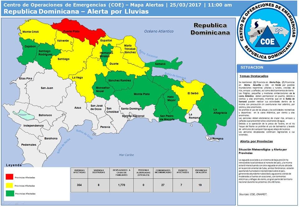
Weather alerts in the Dominican Republic, 25 March 2017.
© Emergency Operations Center of Dominican Republic (COE)Weather alerts in the Dominican Republic, 25 March 2017.
Disaster authorities in the Dominican Republic say that a period of heavy rain caused flooding in northern areas of the country from 23 March 2017.

As of 25 March, 1,770 people had been forced from their homes. Around 364 homes have been damaged and a further 8 completely destroyed. Seven bridges have also suffered some flood damage. At one point around 27 communities were cut off by flood water.


Cloud Precipitation

11 dead following floods and heavy rain in Luanda, Angola

water
At least 11 people have died in the province of Luanda, Angola, after heavy rain and flooding on Tuesday 21 and Wednesday 22 March, 2017. Almost 80 mm of rain fell in 24 hours in the capital.

According to local media, spokesperson for the provincial command of the Civil Protection and Fire Service, Faustino Minguês, told Radio Luanda that the deaths occurred in the municipalities of Cacuaco, Cazenga and Belas and in the urban districts of Sambizanga and Kilamba-Kiaxi in the municipality of Luanda. Several people are also believed to be missing.

Many of the victims died as a result of homes collapsing. Other were swept away by flood water or electrocuted by falling power cables.

According to officials, 5,773 homes have been damaged by floods. Around 344 families have been evacuated. Initial assessments reported that a total of 13 houses have been destroyed. AFP later reported the figure as 700.

Cloud Precipitation

Torrential rains continue to wreak havoc in Peru

Flooding in Peru March 2017
© YouTube/euronews (screen capture)
Heavy rains continue to wreak havoc in Peru.

The floods have claimed at least 78 lives and a state of emergency has been declared covering half of the country.

It is a result of record downpours which caused rivers to overflow, triggered landslides and left thousands homeless.

Climate experts say it is due to the 'coastal El Nino' phenomenon, with exceptionally warm water in the Pacific causing the torrential rains.

On Peru's northern coast, small villages have been totally cut off.

"Recently, I went to see my house which is bad, bad, bad. I lost all my things. I lost practically everything and that is why I was obliged to come here," said one woman displaced by the floods.


Cloud Precipitation

Floods in New South Wales, Australia after 500 mm (20 inches) of rain in a week

Ten staff and four students had to be rescued from a school in Shellharbour yesterday after it was flooded while a school bus got stranded in Albion Park
Some parts of New South Wales (NSW), Australia, have recorded over 500 mm of rain in the last 7 days as a low-pressure system drenched the region.

Over the weekend of 17 to 19 March, parts of the state's northeast and Mid North Coast were hardest hit. On 18 March, Australia's Bureau of Meteorology (BoM) said that 21 stations had recorded more than 100 mm of rain that day and Evans Head had recorded around 100 mm in just two hours.

According to BoM figures, New Italy recorded 506 mm, Mt Seaview 509 mm of rain in 7 days to 20 March 2017.

In an update of 18 March, NSW State Emergency Service (SES), said:
"The worst affected areas have been around the Mid-north Coast and southern areas of the North Coast. According to the Bureau of Meteorology, approximately 150mm of rain fell around the town of Yamba since midnight, which led to the short-term isolation of the town's 6000 residents."

Bizarro Earth

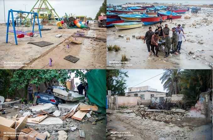
Deadly 'Seiche' waves hit Dayyer, Iran

Deadly Seiche waves smash Dayyer, Iran
© MEHR News Agency / Mehdi RoozbazarDeadly Seiche waves smash Dayyer, Iran on March 19, 2017.
18 people were injured and 6 are still missing after a natural phenomenon called "Seiche" hit the Iranian port city of Dayyer, Bushehr province. The event left behind flooded homes and significant infrastructural damage.

Governor Hamzeh E'temad said giant waves smashed the port city at 08:10 local time on March 19, 2017, injuring 18 people and killing at least 1. Six people are still missing, according to Deputy Governor Namdar Darvishi.

For MEHR News Agency, the head of Bushehr's Persian Gulf Oceanography Centre Ehsan Abedi said the reason behind the giant waves and sea overflow is a natural phenomenon called Seiche. The effect is caused by resonances in a body of water that has been disturbed by one or more of a number of factors, most often meteorological effects (wind and atmospheric pressure variations), seismic activity or by tsunamis.

Seiches are often imperceptible to the naked eye, and observers in boats on the surface may not notice that a seiche is occurring due to the extremely long wavelengths. They can be considered long period or infragravity waves, which are due to subharmonic nonlinear wave interaction with the wind waves, have periods longer than the accompanying wind-generated waves.

Heavy rain and strong winds caused dangerous conditions in the sea, sinking a number of fishing boats.
Cloud Precipitation

70 dead after worst flooding ever in Namibia following on from the severest drought in 25 years

Floods
© Allafrica.comFloodwater in Namibia
The flood situation in the Cuvelai catchment area has reached alarming levels and residents are being warned to take necessary precautions, in expectation of the worst possible flooding experienced here in living memory.

Over 70 people have so far drowned in Oshana, Omusati and Ohangwena regions in Namibia because of heavy downpours.

Over 60 schools in Omusati Region are also reported to have shut their doors, while about some 120 families consisting of 562 individuals have been displaced
at Oshakati and temporarily relocated to Ekuku.

Heavy rainfall is forecast for the areas within the Cuvelai Basin, including Omusati, Oshana, Ohangwena, Kunene, Kavango East and West and the Zambezi regions and residents of those areas are advised to be on high alert for possible flooding.