|
· Met Office: deluge in south is worst in living memory
· Battered north braced for more as front advances
Some of the heaviest rainfall in living memory deluged southern Britain yesterday, inundating places with up to one sixth of their entire annual rainfall in less than 24 hours.
Downpours knocked out satellite communications, cut power, forced schools and homes to be evacuated, and badly disrupted roads and railways.
Emergency services were severely stretched, while one wedding party was last night preparing to bed down in a church after they were surrounded by rapidly rising floodwaters.
London saw its luck run out after having avoided the worst of the recent downpours, while north-east England, parts of which are still suffering from June's monsoon conditions, braced itself for more damage as the rain moved north.
The wettest part of the UK was Brize Norton in Oxfordshire, which received 121.2mm of rain from midnight Thursday until 5pm yesterday - three times its average rainfall for July and a sixth of what it would expect for the whole year.
Steve Randall, a forecaster for the Met Office, said: "I've never seen anything like it, and I've been in the Met Office for 34 years. It's an extraordinary amount, more like you would expect in a tropical rainforest."
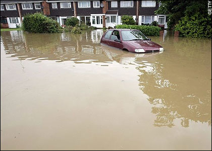
At Barry in south Wales, residents were trapped in their homes as sewage poured into the street. Firefighters used a boat to rescue three people from knee-high water in one building; a man was briefly trapped in his car in a dip below a road bridge. In Sussex, flooding in the Haywards Heath area led to serious train delays, while in Worthing the hospital was flooded to a depth of 18 inches.
The Thames Valley was also hard hit, with Reading and Maidenhead town centres flooded; there were long delays on the M4 after a landslip caused by heavy rain left just one lane open on the eastbound carriageway.
Parts of south-west London saw floods two-feet-deep, and the Underground was badly disrupted.
At Heathrow, 141 flights were cancelled as air traffic controllers grounded aircraft in the worst of the downpours.
A severe weather warning will remain in force today for north Wales and the west Midlands, but the rain is expected to ease off overnight. Summer has no plans to return, however. Sunday is forecast to be showery and dull in most areas, and heavy rain may return to the south on Monday.
The only bright spot was that the worst of the rain kept away from the battered north, where a huge recovery operation is installing thousands of temporary homes for people whose houses have already been wrecked. Only a short-lived outrider of today's storms reached the devastated areas of Yorkshire and Humberside, penetrating as far as Richmond, North Yorkshire, where the sudden volume of water burst the banks of Skeeby beck, flooding homes in six villages.
In Cheltenham, one couple's plans for the perfect wedding went down the drain as they and 100 guests were marooned in their church by floodwaters 5ft deep.
As Sarah Parfitt, 34, married Andy Holtom, 31, at Holy Trinity, torrential rain caused a stream next to the church to swell and burst its banks, sending filthy brown water churning towards the church building. They were confronted by floodwater on stepping out for photographs, and, after calling the fire service, were told to stay put. The new Mrs Holtom said: "When I imagined my wedding day as a little girl, I always thought it would be sunny and totally perfect - I had no idea it would end up like this."


Reader Comments
to our Newsletter