Earthquakes
S


Seismograph

Magnitude 6.1 earthquake jolts Philippines, no casualties reported so far

mapp
An earthquake with a preliminary magnitude of 6.1 jolted Batangas province on the main Philippine island of Luzon on Sunday, the Philippine Institute of Volcanology and Seismology said.

The institute said the quake, which occurred at 5:50 a.m., hit at a depth of 132 km, about 21-km northwest of Calatagan town.

The tremor was also felt in Metro Manila and the provinces of Bulacan and Oriental Mindoro, Xinhua news agency reported.

There were no immediate reports of damage or casualties.

The institute added that the tectonic quake will trigger aftershocks and can cause damage.

The Philippines has frequent seismic activity due to its location along the Pacific "Ring of Fire".

Source: IANS

Seismograph

Magnitude 6.9 earthquake strikes off Macquarie Island

maps
An island located 1,600km southeast of Tasmania has been struck by a magnitude 6.9 earthquake.

The Bureau of Meteorology reported the earthquake near Macquarie Island in the Southern Pacific Ocean at 8:49pm on Thursday (AEDT).

The quake, which was revised from an initial magnitude of 7.4, had a depth of 10km, according to the United States Geological Survey (USCS).

Attention

Iceland Reykjanes volcano update - Alert level raised, magma is on the move

Iceland Reykjanes Volcano
The alert level of the Reykjanes volcano in Iceland was just raised from green to yellow. This change was made in response to the confirmation of a new intrusion of magma on the Reykjanes peninsula. This new intrusion is centered underneath the Svartsengi geothermal power plant, and is quite likely to result in a new volcanic eruption. If an eruption were to occur, it would be likely to have an explosive component to it and potentially affect the city of Grindavik. This video will discuss the odds of a new volcanic eruption and how explosive it might be.


Attention

This week in volcano news - Yellowstone earthquake, unrest at Andes supervolcano

Big Ben
Big Ben
In the last week, there was significant seismic activity at a supervolcano. One of these supervolcanoes has an ongoing intrusion of magma at 3 miles or 5 kilometers depth in Chile and could produce an eruption in the next several months.

Also, in Yellowstone National Park, a magnitude 4.2 quake occurred which led some people to speculate that it was volcanic in origin. And, in Australia, the nation's most active volcano produced a new eruption, sending a lava flow 2.5 kilometers downslope.

This video will discuss these volcano related news stories, as told and analyzed by a volcanologist.


Seismograph

'Monster' quake recorded on Mars by NASA's InSight, largest quake ever detected on another planet

mars quake
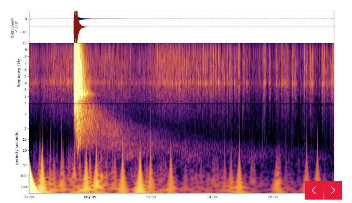
© NASA/JPL-Caltech/ETH ZurichThis spectrograph shows the largest quake ever detected on another planet. Estimated at magnitude 5, this quake was discovered by NASA's InSight lander on May 4 2022, the 1,222nd Martian day, or sol, of the mission.
NASA's InSight Mars lander has detected the largest quake ever observed on another planet: an estimated magnitude 5 temblor that occurred on May 4, 2022, the 1,222nd Martian day, or sol, of the mission. This adds to the catalog of more than 1,313 quakes InSight has detected since landing on Mars in November 2018. The largest previously recorded quake was an estimated magnitude 4.2 detected Aug. 25, 2021.


Comment: Notably the two largest were recorded more recently.


InSight was sent to Mars with a highly sensitive seismometer, provided by France's Centre National d'Études Spatiales (CNES), to study the deep interior of the planet. As seismic waves pass through or reflect off material in Mars' crust, mantle, and core, they change in ways that seismologists can study to determine the depth and composition of these layers. What scientists learn about the structure of Mars can help them better understand the formation of all rocky worlds, including Earth and its Moon.

Comment: See also: And check out SOTT radio's: MindMatters: The Holy Grail, Comets, Earth Changes and Randall Carlson


Seismograph

6.8-magnitude earthquake hits Argentina: USGS

MAPS
An earthquake with a magnitude of 6.8 jolted 78 km NNW of San Antonio de los Cobres, Argentina at 23:06:29 GMT on Tuesday, the U.S. Geological Survey said.

The epicenter, with a depth of 193.81 km, was initially determined to be at 23.6141 degrees south latitude and 66.7236 degrees west longitude.


Seismograph

Shallow 6.3-magnitude earthquake strikes off Papua New Guinea

maps
A 6.3-magnitude earthquake struck Tuesday in the Bismarck Sea about 200 kilometres (120 miles) off Papua New Guinea's coast, the US Geological Survey said.

A preliminary USGS assessment said there was a "low likelihood of casualties and damage from the quake", which had an estimated depth of 10 kilometres. There were no tsunami warnings.

Papua New Guinea sits on the so-called Pacific Ring of Fire, which is a hotspot for seismic activity due to friction between tectonic plates.

A 7.5-magnitude quake that hit the rugged highlands region in February 2018 triggered landslides, burying homes and killing at least 125 people.

Source: AFP

Seismograph

6.3-magnitude earthquake strikes off Taiwan's coast

maps
A 6.3-magnitude earthquake struck off the coast of Taiwan on Monday afternoon, according to the U.S. Geological Survey, with buildings in capital Taipei sent swaying.

The offshore quake hit just before 2:30 p.m. at a depth of 27 kilometers (17 miles), about 70 km southwest of Okinawa's Yonakuni Island, not far from Taiwan, according to the USGS report.

Taiwan's Central Weather Bureau said the shake, the fifth this year above a magnitude of 6.0, was felt across the island, though there were no immediate reports of damage.


Seismograph

6.0 magnitude quake hits Philippine Islands

maps
An earthquake of magnitude 6.0 on the Richter scale hit Philippine Islands on Thursday, the National Center for Seismology (NCS) confirmed.

"Earthquake of Magnitude:6.0, Occurred on 05-05-2022, 13:51:19 IST, Lat: 6.55 & Long: 127.11, Depth: 20 Km ,Location: Philippine Islands," NCS tweeted.

Earlier, the Philippine Institute of Volcanology and Seismology said that a magnitude of 5.7 jolted Davao Oriental province in the southern Philippines.

The quake, which occurred at 5:41 a.m. local time (2141 GMT Wednesday), hit at a depth of 96 km, about 136 km southeast of Tarragona town of Davao Oriental province, according to the Philippine Institute of Volcanology and Seismology.

There are no reports of casualties or loss of properties as of now.

Further details are awaited. (ANI)
Seismograph

Magnitude 6.0 earthquake in Bismarck Sea near Papua New Guinea

maps

Very strong magnitude 6.0 earthquake at 10 km depth

Date & time: Apr 28, 2022 13:21:13 UTC
Local time at epicenter: Thursday, Apr 28, 2022 at 11:21 pm (GMT +10)
Magnitude: 6
Depth: 10.0 km
Epicenter latitude / longitude: 3.8986°S / 146.6605°E (Bismarck Sea, Papua New Guinea)