Earthquakes
S


Seismograph

6.6 magnitude earthquake shakes Fiji

nnnn
A strong earthquake jolted the South Pacific island nation of Fiji on Tuesday, the US Geological Survey (USGS) said.

The USGS said 6.6 magnitude earthquake on Richter scale hit southern Fiji at around 4.31 p.m. (0431GMT) with a depth of 562.5 kilometers (349.5 miles).

There has been no registered damage, according to the latest reports.

Info

Warm liquid spewing from Oregon seafloor comes from Cascadia fault, could offer clues to earthquake hazards

Pythias Oasis
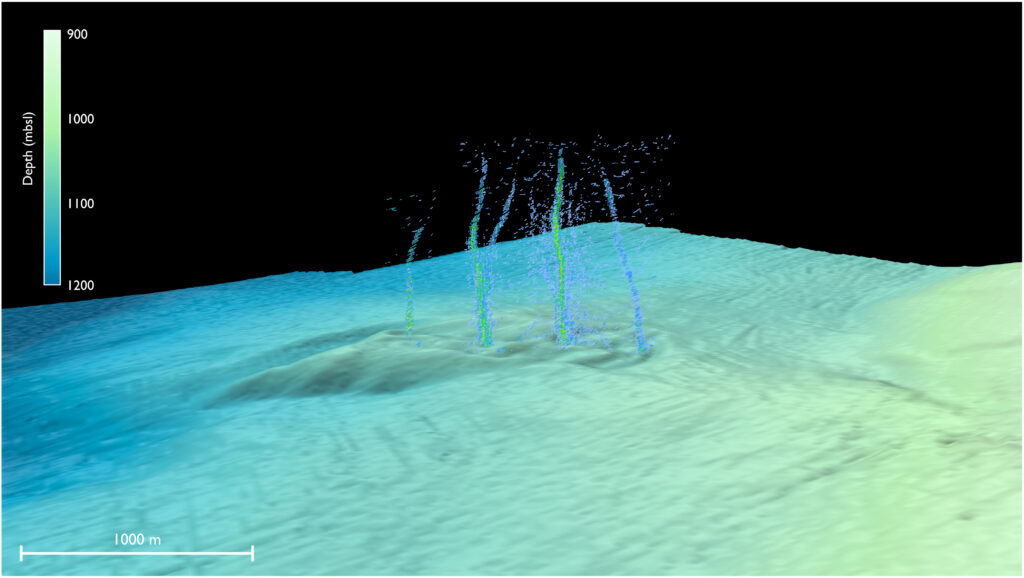
© Philip et al./Science AdvancesThis sonar image of the Pythias Oasis site shows bubbles rising from the seafloor about two-thirds of a mile deep and 50 miles off Newport, Oregon. These bubbles are a byproduct of a unique site where warm, chemically distinct fluid gushes from the seafloor. Researchers believe this fluid comes directly from the Cascadia megathrust zone, or plate boundary, and helps control stress buildup between the two plates.
The field of plate tectonics is not that old, and scientists continue to learn the details of earthquake-producing geologic faults. The Cascadia Subduction Zone โ€” the eerily quiet offshore fault that threatens to unleash a magnitude-9 earthquake in the Pacific Northwest โ€” still holds many mysteries.

A study led by the University of Washington discovered seeps of warm, chemically distinct liquid shooting up from the seafloor about 50 miles off Newport, Oregon. The paper, published Jan. 25 in Science Advances, describes the unique underwater spring the researchers named Pythia's Oasis. Observations suggest the spring is sourced from water 2.5 miles beneath the seafloor at the plate boundary, regulating stress on the offshore fault.

The team made the discovery during a weather-related delay for a cruise aboard the RV Thomas G. Thompson. The ship's sonar showed unexpected plumes of bubbles about three-quarters of a mile beneath the ocean's surface. Further exploration using an underwater robot revealed the bubbles were just a minor component of warm, chemically distinct fluid gushing from the seafloor sediment.

"They explored in that direction and what they saw was not just methane bubbles, but water coming out of the seafloor like a firehose. That's something that I've never seen, and to my knowledge has not been observed before," said co-author Evan Solomon, a UW associate professor of oceanography who studies seafloor geology.

The feature was discovered by first author Brendan Philip, who did the work as a UW graduate student and now works as a White House policy advisor.

Observations from later cruises show the fluid leaving the seafloor is 9 degrees Celsius (16 degrees Fahrenheit) warmer than the surrounding seawater. Calculations suggest the fluid is coming straight from the Cascadia megathrust, where temperatures are an estimated 150 to 250 degrees Celsius (300 to 500 degrees Fahrenheit).

Seismograph

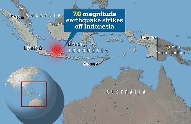
Powerful 7.0-magnitude earthquake strikes off Indonesia

The quake was at a depth of 368 miles, EMSC said, and struck at 4:55 pm local time (0955 GMT), with Indonesia's geological agency ruling out a tsunami
An earthquake of magnitude 7.0 struck Java, Indonesia on Friday, the European-Mediterranean Seismological Centre (EMSC) said.

The quake was at a depth of 368 miles, EMSC said, and struck at 4:55 pm local time (0955 GMT), with Indonesia's geological agency ruling out a tsunami.

The quake was strongly felt in Surabaya, Tuban, Denpasar, and Semarang, Abdul Muhari, spokesperson for Indonesia's Disaster Agency, told Reuters news agency.

'There is no damage reported so far because the quake is very deep,' Muhari said. 'I don't think there will damages but we are still monitoring.'

Indonesia straddles the so-called 'Pacific Ring of Fire', a highly active seismic zone, where different plates on the Earth's crust meet and create a large number of earthquakes and volcanoes.

Seismograph

Shallow earthquake off British Columbia coast measuring magnitude 6

MMMMMMM
An earthquake measuring 6 has shaken the seabed a few hundred kilometres off Vancouver Island.

The National Tsunami Warning Center in Alaska says a dangerous wave is not expected from the quake.

The U.S. Geological Survey website shows the quake was only lightly felt in areas ranging from Port Hardy, just over 200 kilometres from the epicentre, to Kitimat, more than 500 kilometres away.

Earthquakes Canada estimated the quake that happened at about 8 a.m. local time was magnitude 5.8, while the tsunami warning centre said it reached 6.2.

Comment: The U.S. Geological Survey also reports the depth as just 7.3 kms.


Seismograph

Shallow 6.0 magnitude earthquake strikes off Papua New Guinea

mmmmmmmm
An earthquake measuring 6.0 on the Richter scale struck Papua New Guinea on Monday.

The USGS said the epicenter was at a depth of 10 km, at 3.50 degrees south latitude and 149 degrees east longitude, 224.6 km southeast of Kavieng city.

There were no immediate reports of casualties or material losses due to the earthquake.

Papua New Guinea is located along the Pacific Ring of Fire, where many volcanic eruptions and earthquakes occur. This region includes 90 percent of the active volcanoes in the world.

Seismograph

Panama jolted by strong 6.3-magnitude quake off Pacific coast, no casualties reported

MMMMMMM
A strong 6.3-magnitude earthquake struck Tuesday off Panama's Pacific coast near the town of Boca Chica.

The US Geological Survey said the quake hit at 5:18 local time (22:18 UTC) and its epicenter was about 44 miles (71 kilometres) south of Boca Chica. The earthquake occurred at a depth of eight miles (13 kilometres).

Panama's civil defense office said there were no immediate reports of damages. But the office said the quake was felt on nearby Coiba Island.

National Civil Defense Director Carlos Rumbo told local press that his office had not received reports of damage or injuries, but was continuing to check with people in the provinces along the Pacific coast.

Source: Associated Press

Seismograph

Shallow magnitude 6.2 earthquake strikes off coast of Viga in Philippines

mmmmmm
A 6.2-magnitude earthquake struck in the ocean off the coast of the eastern Philippines on Tuesday, the US Geological Survey said, with local authorities warning of aftershocks and possible damage.

The shallow quake hit around 9:00 pm (1300 GMT) about 120 kilometers (74 miles) from Catanduanes Island, off the main island of Luzon, the USGS said.

Shallow quakes tend to cause more damage than deeper ones, but so far there have been no immediate reports of damage on Catanduanes.

Seismograph

6.1-magnitude quake strikes off Indonesia's Sumatra island: USGS

The epicentre of the earthquake off Indonesia on Apr 3, 2023.
A 6.1-magnitude earthquake struck off Sumatra island in western Indonesia on Monday (Apr 3), shaking homes of panicked residents but causing no casualties or damage.

The quake's epicentre was at sea southwest of Padangsidempuan city in northern Sumatra at a depth of 84 kilometres, the United States Geological Survey (USGS) reported.

It occurred around 9.59pm.

The country's meteorology and geophysics agency said there was no tsunami warning after the tremor but told residents nearest the epicentre to beware of potential aftershocks.

Seismograph

Strong 6.5-magnitude earthquake strikes Russia's Far East

The epicenter of the earthquake
The epicenter of the earthquake.
A strong magnitude 6.5 earthquake has struck the Kamchatka Peninsula in Russia's Far East, according to seismologists and residents. Strong shaking was felt near the epicenter but there is no threat of a tsunami.

The earthquake struck at 03:06 p.m. local time on Monday, according to the U.S. Geological Survey (USGS), with the epicenter located about 10 kilometers from Vilyuchinsk or 28 kilometers from Petropavlovsk-Kamchatsky, the capital of the Kamchatka region.

"Based on all available data, a destructive Pacific-wide tsunami is not expected," the Pacific Tsunami Warning Center said in a statement.

Comment: About 9 hours earlier: Powerful 7.0-magnitude earthquake hits Papua New Guinea


Seismograph

Powerful 7.0-magnitude earthquake hits Papua New Guinea

The epicenter of the earthquake
The epicenter of the earthquake.
A powerful earthquake measuring 7.0 has struck Papua New Guinea, seismologists and residents say. Homes were destroyed near the epicenter but only few details were immediately available.

The earthquake, which struck at 3:04 a.m. local time on Monday, was centered in Chambri Lake, about 37 kilometers east of Ambunti or 96 kilometers southwest of Wewak, the capital of East Sepik province.

The U.S. Geological Survey (USGS) put the earthquake's magnitude at 7.0, a significant downgrade from earlier estimates of 7.3 and 7.9. It struck about 62 kilometers below the surface, making it a fairly deep earthquake.

Comment: About 9 hours later: Strong 6.5-magnitude earthquake strikes Russia's Far East