Earth ChangesS


Cloud Lightning

Tornado leaves 3 dead in Missouri

Image
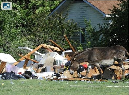
© Adam Vogler, APA donkey wanders through debris in the backyard of Loy Miller's home after a tornado passed through the area in Diehkstadt, Missouri on Tuesday
A man and his two adult sons died when a tornado obliterated a mobile home in southeast Missouri, officials said Tuesday.

The twister was part of a storm that struck Missouri, Illinois and Kentucky late Monday, but hit hardest in the tiny village of Diehlstadt, in Scott County, where the three men were killed.

Scott County Sheriff Rick Walter said the mobile home was smashed beyond recognition.

"The frame was probably 100 yards away from where it was sitting," Walter said. "It was just debris everywhere. It just obliterated it."

Cloud Lightning

Storm brings golfball-sized hail, tornado to Montana

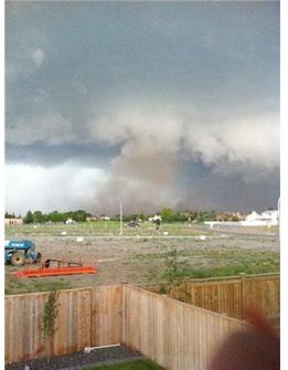
A storm system that moved north through central Montana has brought hail and at least one tornado in the rural Hobson area, leaving behind downed trees and power lines.

Central Montana 911 dispatcher Dorothy Gremaux says there were no immediate reports of injuries Tuesday night, but cars, houses and outbuildings have been damaged.

National Weather Service meteorologist Jim Brusda says funnel clouds were reported near White Sulphur Springs. He says law-enforcement officers reported a tornado touching down in the Coffee Creek area north of Hobson and moving toward Big Sandy.

He says golf ball-size hail was reported in White Sulphur Springs, penny-size hail in Bozeman and pea-size hail in the Great Falls area.

The storms then moved across the Canadian border into Alberta, where at least one tornado was spotted near Taber.

Source: Associated Press

Cloud Lightning

Tornado touches down in Perth, Australia


A Mini-tornado has ripped through suburban Perth, ripping down powerlines and trees and leaving a trail of damage.

Several reports on Twitter described the storm as a "small tornado''. It is believed the destructive winds centred on Light Street, Dianella and Alexander Drive, and hit around midday WA time.

A real estate office and video store on Walter Road, Morley, has been damaged with the roof torn off and one wall collapsed.

Nobody was injured in the building collapse. Several cars may also have been damaged.

The Bureau of Meteorology confirmed that a "tornado'' was reported in the Tuart Hill/Morley/Dianella area just after midday.

Cloud Lightning

Taber, Calgary damaged by tornado

N
Image
© Shannon Reynolds, THE CANADIAN PRESSDust is kicked up as tornado touches down in Taber, Alberta on Tuesday June 5, 2012. A strong storm cell moving north out of Montana triggered several tornado warnings and watches between Coaldale and Taber.
o injuries but toll includes downed power lines, countless trees, smashed windows, minor flooding, torn-off shingles


Cam Cleland watched helplessly from his brick farmhouse as 25-metre-tall poplar trees were snapped over like dominoes as a tornado passed through the region Tuesday night.

Located seven kilometres south of Taber, his property would have likely been in direct line of the tornado that pulverized the southern Alberta town.

"I'm just glad it didn't snap all the big ones that would have fallen on my house," Cleland said Wednesday, adding 20 to 25 trees were knocked over in total.

Across southern Alberta, there were reports of severe weather that included strong winds, flash flooding, golf ball-sized hail and three unconfirmed reports of tornadoes near Brooks, Bow Island and Vulcan.

Bizarro Earth

USGS: Earthquake Magnitude 6.0 - Southern Peru

Image
© USGS
Date-Time
Thursday, June 07, 2012 at 16:03:18 UTC
Thursday, June 07, 2012 at 11:03:18 AM at epicenterTime of Earthquake in other Time Zones

Location
15.919°S, 72.516°W Depth
99.7 km (62.0 miles) Region
SOUTHERN PERU

Distances
119 km (74 miles) WNW (298°) from Arequipa, Peru
216 km (134 miles) SE (128°) from Puquio, Peru
221 km (137 miles) NW (310°) from Moquegua, Peru
648 km (402 miles) SE (131°) from LIMA, Peru

Cloud Lightning

Severe Colorado Storm: Large Hail, Tornado Near Denver International Airport And Heavy Flooding Around Front Range

April showers bring May flowers, but what do June hail storms and tornadoes bring? After several days of warm weather, on Wednesday night the Colorado sky opened up and unleashed severe weather upon the state delivering spectacular lightning, large hail balls and even some weak tornadoes around the Front Range.


Cloud Lightning

Severe weather rips through southern Ontario

Image
© Kristina LombardiA viewer sent in this photo of a rain shaft over her home in west Toronto near Kipling Avenue and The Queensway on Wednesday, June 6, 2012.
A band of thunderstorms prompted Environment Canada to issue tornado warnings for parts of cottage country north of Barrie, including Parry Sound, Rosseau, Killbear Park, Hunstville and Baysville, Wednesday evening.

The warning, issued shortly after 5 p.m., said the severe thunderstorms in the area had the potential to produce large hail, damaging winds and heavy rainfall, as well as tornadoes. The tornado warnings ended just before 7 p.m.

Bizarro Earth

State officials warn of growing dangers of a massive mudflow on Mount Rainier

Image
© Unknown
A new report from the Washington State Department of Natural Resources (DNR) estimates that a volcanic mudflow (known as a 'lahar') from Mount Rainier could produce property losses of up to $6 billion to communities in the Puyallup Valley.

"We now have a much better estimate of the economic impact of a major lahar flowing from Mount Rainier," said Dave Norman, Washington State Geologist and manager of the DNR Geology and Earth Resources Division." It's not a question of if, but when, the next volcanic event will occur."

The DNR report, "Loss Estimation Pilot Project for Lahar Hazards from Mount Rainier, Washington," is based on data about several previous lahars from the volcano. Using loss-estimating software developed by the Federal Emergency Management Agency (FEMA), the report projects potential property damage costs if similar mudflows occurred again on Mount Rainier's west side, as many geologists anticipate.

Due to the weakened rocks that make up the upper west flank of Mount Rainier, the Puyallup Valley is considered highly susceptible to lahars. Lahar-related flooding has the potential to reach as far as the Commencement Bay and Elliott Bay, including the ports of Seattle and Tacoma.

Bizarro Earth

First ever 4.0 earthquake off Ireland's Atlantic coast surprises geologists

Ireland Quake
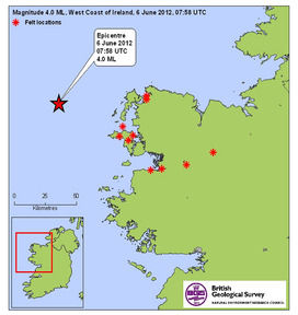
© British Geological SurveyEarthquake strikes off Co Mayo coastline - Map showing locations from where people reported that the felt the affects of this morning’s earthquake, which struck 60km off the Co Mayo coastline.
A leading seismologist has said yesterday's earthquake off the west coast was "unexpected" and poses "very interesting questions for geologists".

The earthquake, which registered a magnitude of four on the Richter scale, was recorded as 60km west of Belmullet, Co Mayo, at a depth of 3km, at 8.58am. It was the largest local seismic event ever recorded, according to Tom Blake of the Irish National Seismic Network (INSN) and the Dublin Institute of Advanced Studies.

It was also the second-largest local earthquake on record in either Britain or Ireland, he said - the first being of 5.4 magnitude on July 19th, 1984, off the west coast of Wales and felt in Waterford and Wicklow.

A 2.7 magnitude tremor was recorded in Lisdoonvarna, Co Clare, in May 2010.

The Irish Coast Guard recorded instances of structural damage to houses in Erris, Co Mayo, yesterday and the British Geological Survey said the impact was felt in Galway, Mayo and Sligo.

The Geological Survey of Ireland said earthquakes of this magnitude at this depth were "not very unusual although not common".

However, Mr Blake said that while the earthquake was classified as "moderate", it was "significant" in that it challenged existing information about seismic activity off the west coast.
Attention

Tipping Point? Earth Headed for Catastrophic Collapse, Researchers Warn

Earth
© NASA/NOAA/GSFC/Suomi NPP/VIIRS/Norman KuringThis composite image uses a number of swaths of the Earth's surface taken on January 4, 2012.
Earth is rapidly headed toward a catastrophic breakdown if humans don't get their act together, according to an international group of scientists.

Writing Wednesday (June 6) in the journal Nature, the researchers warn that the world is headed toward a tipping point marked by extinctions and unpredictable changes on a scale not seen since the glaciers retreated 12,000 years ago.

"There is a very high possibility that by the end of the century, the Earth is going to be a very different place," study researcher Anthony Barnosky told LiveScience. Barnosky, a professor of integrative biology from the University of California, Berkeley, joined a group of 17 other scientists to warn that this new planet might not be a pleasant place to live.

"You can envision these state changes as a fast period of adjustment where we get pushed through the eye of the needle," Barnosky said.

"As we're going through the eye of the needle, that's when we see political strife, economic strife, war and famine."