Earth ChangesS


Ice Cube

Extreme cold that gripped Canadian Arctic expected to invade eastern US

us cold prediction
© Twitter/@Ryan Maue
In recent days, some of the coldest March air in decades has gripped portions of Alaska and the Canadian Arctic. Fragments of that frigid air will come crashing into the eastern United States on Friday and into the weekend.

The air spilling into the Great Lakes, Northeast and Mid-Atlantic may not fall to record levels, but it could bring the coldest weather to parts of the region since January.

Its pedigree is impressive.

On Saturday, Mould Bay in the Canadian Arctic set an all-time record low of minus-66.5 degrees (minus-54.7 Celsius).

Attention

Whale washes up on beach in Devon, UK

The mammal is either a baleen or a fin whale
© Paul Willby/SWNS.COMThe mammal is either a baleen or a fin whale
A whale's dead body measuring at least 9 metres long has washed up on a Devon beach.

The mammal's body - said to be a fin or a baleen whale - was first spotted at 4pm yesterday after it was washed ashore near Hartland Quay.

Cheryl Fan Duerden wrote on Facebook: "Back from a BDMLR call out this evening to check on a whale that washed up on Hartland Quay.

"Exceptionally foggy drive and not the easiest access through slippery jagged rocks in the dark, but someone's gotta do it!

"Unfortunately it was dead, possibly a while ago, 9-10 metres at least and suspected small fin whale or large minke whale.

"Very sad to see it flopped over and lodged amongst the rocks and blood in the rockpools, but to see a whale in its entirety is still pretty awesome."

Snowflake

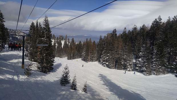
10 resorts in California's Central Sierra mountains receive 50 feet or more snowfall for the season so far

A March 6 shot of Heavenly, after nearly two feet of snow had dumped over the weekend.
© Elizabeth RauchA March 6 shot of Heavenly, after nearly two feet of snow had dumped over the weekend.
This year's snowfall count has been creeping higher and higher with each winter storm that has hit Lake Tahoe, causing several area resorts to hit a notable mark: Northstar, Kirkwood and Heavenly all either reached or surpassed 600 inches of snow on the season after this most recent storm. Put another way, that's 50 feet of snow.

As of March 7, Northstar, Kirkwood and Heavenly have all collected between 600 and 612 inches.

It should be noted, however, that these aren't the only resorts piling on the powder. There are a total of 10 resorts in the region that have surpassed 600 inches this year. At a virtual tie, Mt. Rose and Sugar Bowl are leading the pack and nearing 700 inches. Mt. Rose is boasting 680 inches, while Sugar Bowl is just behind at 679.

Bizarro Earth

3-hour volcanic eruption in Alaska threatens villages with ash

Bogoslof Volcano
© Wikipedia
An Alaskan volcano experienced its largest eruption to date and created a large ash cloud. For the past several months, Bogoslof Volcano has had minor eruptions, but the most recent was its strongest, sending ashes 35,000 feet above sea level.

Residents of the Aleutian Islands are under ash advisory after Bogoslof Island's volcano had its strongest recorded eruption Tuesday night. The National Weather Service warned that the fishing communities could see a trace amount of ash following the powerful eruption.

This isn't the first time the volcano has erupted. Tuesday was the 36th recorded eruption over the last three months, with the next most recent one occurring February 19, CNBC reported. However, the length of the eruption and intensity were unexpected.

"It was the most significant event for the entire eruption," US Geological Survey geologist Kristi Wallace told CNBC.

Arrow Up

Powerful eruption of Bezymianny volcano, Russia; ash ejected up to 10 km (33,000 feet)

Russia's Bezymianny volcano eruption
© KB GS RASBezymianny eruption on March 9, 2017.
A powerful eruption took place at Bezymianny volcano, Kamchatka, Russia around 03:00 UTC on March 9, 2017. The Aviation Color Code was first raised to Orange, then to Red.

Tokyo VAAC said at 03:42 UTC, that an eruption at Bezymianny at 03:00 UTC sent ash up to 10 km (33 000 feet) extending N-NW.

According to satellite data by KVERT, ash plume at the height about 7 km (23 000 feet) a.s.l. drifts for about 112 km (70 miles) to the northwest from the volcano, KVERT said at 05:11 UTC. The width of ash plume is about 14 km (8.7 miles). Strong gas-steam activity of the volcano continues, it said.

Strong ash explosions up to 15 km (49 200 feet) a.s.l. could occur at any time. Ongoing activity could affect international and low-flying aircraft.

Based on KB GS RAS (Kamchatka Branch of Geophysical Services, Russian Academy of Sciences) data, KVERT noted that seismicity at Bezymianny began to increase on November 18, 2016. The temperature of a thermal anomaly detected in satellite images increased on December 5, and then significantly increased on December 13, which was likely caused by lava-dome extrusion. The Aviation Color Code was raised to Orange.

Attention

Shallow magnitude 4.6 earthquake shakes Switzerland; largest for 12 years

Switzerland earthquake
© Swiss Seismology ServiceThis map shows where Monday's earthquake struck.
An earthquake of magnitude 4.6 on the Richter scale hit central Switzerland on Monday night, the Swiss Seismology Service (SED) has said. The quake struck at 9.12pm at a depth of 5km under the summit of the Ortstock mountain in the canton of Glarus, around 6km west of the town of Linthal, the SED announced on its website.

While no damage was reported, police in the cantons of Glarus and Schwyz told news agency ATS they received dozens of calls from worried residents who felt the quake.

The SED said it received reports that the quake was also felt in the cantons of Bern, Aargau, Zurich and Graubünden.

So many people visited the SED's website after the earthquake that it crashed, said the service.

About a dozen aftershocks were detected after the main event, with more to be expected in the coming days.

"It is unlikely that there will be an earthquake with a similar or even larger magnitude than the main shock but this cannot be excluded," it added.

Comment: More earthquakes than usual shook Switzerland last year


Arrow Up

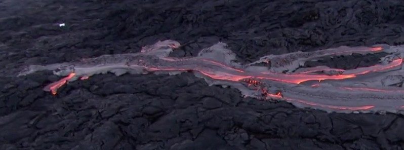
Huge new lava outbreak at Kilauea volcano, Hawaii (VIDEO)

Kilauea volcano lava flow
© Tropical Visions Video, Paradise Helicopters / BigIslandNow.com
A huge new outbreak just above the pali to the south of the Kilauea's 61g flow is sending many lava streams downslope, Tropical Visions videographer Mick Kalber and the Paradise Helicopters crew reported after an overflight on March 2, 2017.

"Truly an amazing amount of activity," Kalber said.

Kilauea's current Aviation Color Code is at Orange, Volcano Alert Level is at Watch, AVO reported late March 7.

The episode 61g lava flow from Puʻu ʻŌʻō is entering the ocean at Kamokuna and is feeding surface flows on and above the pali, and on the coastal plain, inland from the ocean entry, but these lava flows pose no threat to nearby communities at this time. The summit is deflating, and the lava lake was 33 m (~108 feet) below the Overlook crater rim on the morning of March 7 (local time).

Summit tremor continues to fluctuate in response to variations in lava lake spattering. Average daily summit sulfur dioxide emission rates were about 3 000 metric tons/day last week, the most recent time when conditions permitted measurements. After a brief increase, seismicity in the upper East Rift Zone has returned to typical levels over the past day, with just a few small earthquakes.
Comment: There has been increased activity at Hawaii's Kilauea volcano in recent months: Volcanoes are erupting across the planet with 35 currently active which prompts the question: Is something strange happening deep inside the Earth?


Snowflake

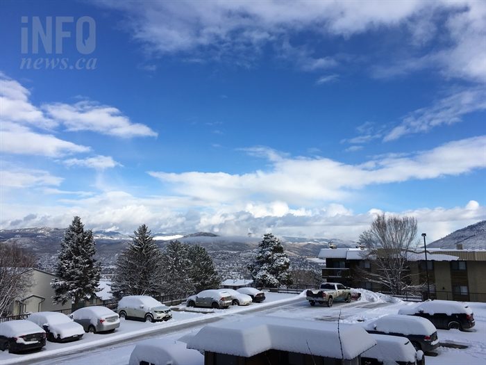
A months' worth of snow fell in just 2 hours on Kamloops, Canada

A truck plows a parking lot in Sahali as Kamloops residents dig out of a surprise snow storm March 8, 2017.
© BRENDAN KERGIN / iNFOnews.caA truck plows a parking lot in Sahali as Kamloops residents dig out of a surprise snow storm March 8, 2017.
A month's worth of snow fell in about two hours this morning in Kamloops, leading to slow roads and car crashes.

The vast majority of the snow arrived between 4 a.m. and 6:30 a.m. Environment Canada meteorologist Alyssa Charbonneau says while only 3 centimetres were reported at the Kamloops Airport, she's seen unverified reports of up to 10 cm around the city.

"There was a line of heavy flurries that swept through the Kamloops and South Thompson area," she says. "It was quite intense and it was actually fairly localized."

The flurries hit Kamloops hard though, with streets slick with snow before crews could clear them. In the downtown area, Coun. Denis Walsh witnessed a pedestrian nearly crushed by a pickup truck after the driver lost control and slide sideways through the intersection at 3 Avenue and Seymour Street and into the building on the northeast corner of the intersection.

"The man pushed off the building," Walsh says. "He got his hand stuck by the truck, otherwise he'd be pasted up against the building."

Cloud Precipitation

Roads closed, campers evacuated following floods in Auckland and Coromandel, New Zealand; 10 inches of rain in 24 hours

Flooding in the Hunua Ranges Regional Park.
© Auckland CouncilFlooding in the Hunua Ranges Regional Park.
A storm and heavy rain overnight from 07 to 08 March caused flooding and power cuts across Auckland and the Coromandel Peninsula in New Zealand on 08 March 2017.

Golden Valley in Coromandel recorded over 250 mm of rain in 24 hours. The Wairoa River near Clevedon rose by around 5 metres in just a few hours.

Several roads were closed due to flooding, slips and fallen trees, specifically in the Kawakawa Bay and Clevedon areas and also Waiheke Island.

Auckland Civil Defence and Emergency Management issued a warning to drivers:
"If you're commuting from south east Auckland today please consider delaying trip or drive with extreme care. Never drive through flood waters."

Attention

Iconic Maltese arch the Azure Window collapses

Tourists walk near the Azure Window
© Darrin Zammit Lupi / Reuters Tourists walk near the Azure Window
The famous Azure Window rock formation on the island of Gozo in Malta, which has appeared in films and TV shows, including "Game of Thrones", has collapsed after a strong storm.

The Azure Window, a local landmark and major tourist attraction in Malta, collapsed into the sea on Wednesday morning, after withstanding centuries of attacks from the natural elements. The news has devastated locals and tourists alike.

"Heartbreaking," Maltese Prime Minister Josef Muscat tweeted on the loss of the Azure Window (Tieqa tad-Dwejra in Maltese).

"There was a big raging sea beneath the window," local resident Roger Chessell told the Times of Malta." Suddenly, the arch collapsed into the sea with a loud whoomph, throwing up a huge spray. By the time the spray had faded, the stack had gone too."