|
| ©USGS/Gary D. Clow |
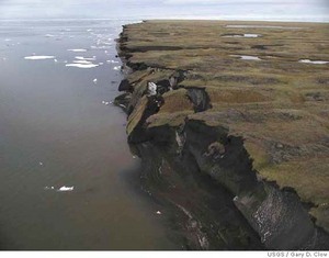
| A cliff collapses into the Beaufort Sea on Alaska's north coast, as the permafrost melts and no longer holds that earth solid. |
Using evidence from satellite observations and aerial photographs, two geologists at the U.S. Geological Survey have concluded that pack ice shrinking rapidly over the Beaufort Sea has probably caused the waves to surge more powerfully against the weakened cliffs.
At the same time small inland lakes have expanded as ice covering their surface has melted away, the scientists say.
In some instances the land-locked margins of ice-covered lakes that were isolated from the coast 50 years ago have moved north until erosion has turned them into open bays exposed to continuous flooding by ocean water, the geologists say.
John Mars and David Houseknecht of the survey's headquarters in Reston, Va., analyzed 50-year-old topographic maps made from aerial photographs and images from Landsat satellites run by NASA and the survey for their findings.
Their study area was a 400-mile strip of coast between the Eskimo town of Barrow and the oil-pumping center at Prudhoe Bay in what is now the National Petroleum Reserve.
With waves breaking more and more strongly against the shore as the protective pack ice melts, the coastal erosion has pushed the shoreline back more than a half-mile since 1955, the geologists said.
The erosion rate is speeding, too, and in the 30 years from 1955 to 1985, the coast in the study area lost an average of 120 acres a year, but during the following 20 years the loss of land from erosion along the coast averaged nearly 270 acres a year, the scientists said.
"The waves undercut the mud-rich permafrost land, causing it to collapse into the sea," Mars said.
Ocean water has surged into many freshwater lakes in the region as the coastal land retreated, while melting permafrost has threatened the calving grounds of large caribou herds and changed the environment for waterfowl and other migratory birds, the report noted.
Climate change in Alaska has caused average temperatures there to rise by as much as 3.6 to 5.4 degrees Fahrenheit, according to the international Arctic Climate Impact Assessment.
And while the USGS scientists did not directly blame global warming for the results of their analysis, the report did say that "on this sensitive area, land and resource managers must consider the natural effects of a 30-year warming trend that has resulted in ice-pack shrinkage and deterioration of permafrost, as well as the potential impact of proposed human activity."
The human activity they noted is an increase in petroleum leases throughout Arctic Alaska's North Slope that has been proposed by the Bush administration and that Alaska conservation organizations and Inupiat Eskimo communities have opposed.


Reader Comments
to our Newsletter