Extreme Temperatures
S


Ice Cube

And up next.... Global temperatures plunge in April - "the pause" returns

global warming graph
Global temperatures have dropped 0.5° Celsius in April according to Dr. Ryan Maue. In the Northern Hemisphere they plunged a massive 1°C . As the record 2015/16 El Nino levels off, the global warming hiatus aka "the pause" is back with a vengeance. He writes:
Some good news to end April, global temperature anomaly has fallen to only +0.1°C today (snapshot) ... graphic is like stock market trace
Global Ocean Temperatures Drop To Pre-El Nino Levels
el nino levels graph

Ice Cube

Record snowfall at Russia's Mutnovskaya Geothermal power station

Russia's Mutnovskaya Geothermal power station
"Mutnovskaya geothermal power station in Kamchatka faced a record-breaking amount of snow during winter 2017."

Thanks to Clay Olson for this link

Comment: One picture says it all.


Ice Cube

Exposing the Phony CO2 Con Job - Video

CO2 levels
CO2 levels are now almost the lowest in more than 500 million years.

Using data from the NOAA and even the IPCC, it turns out that CO2 levels were as much as 15 times higher than 400 ppm in the past, and notably, this was long before the Industrial Revolution. In fact, plants across the planet today are starving for CO2. This rational, science-based explanation completely DEBUNKS the false "climate change" narrative on carbon dioxide.

The video points out that CO2 levels today are almost the lowest they've ever been in the entire known history of our planet.

Thanks to Stephen Bird for this video


Snowflake

Snowstorm pounds western Kansas, closes I-70; up to 25 inches of snow reported

A truck is seen in the snow Sunday morning on a Garden City, Kan., street.
© Kris SmithA truck is seen in the snow Sunday morning on a Garden City, Kan., street.

Heavy snow in parts of western Kansas led to a bevy of road closures and power outages on Sunday - and an Amtrak train traveling from Garden City to Lamar, Colo., a distance of 100 miles, arrived 10 hours late.

As much as 14 inches of snow had fallen in Elkhart, near the Kansas-Oklahoma state line and just miles from the Colorado state line, and many trees and power lines were reported down in the southwest part of the state, according to a meteorologist with the National Weather Service in Dodge City.

Jeff Johnson said some of the places hardest hit by the weekend storm included areas west of Garden City and Liberal. He said the Dodge City area had received as much as 5-plus inches of snow as of 11:30 a.m. Sunday.

Garden City reported some power outages, but by 4 p.m. Sunday, the city tweeted that much of the power had been restored. It warned, however, that more power outages could follow and that the Horace Good Middle School would be open for any residents in Finney County without power. Residents of Garden City's utility company were encouraged to call 620-276-1290 to report power outages to help take off some of the calls to the county's 911 dispatch center.


Snowflake

Powerful spring storm brings snow and rain to Nebraska

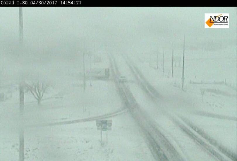
April 30th, 2017 spring storm drops snow near Cozad, NE. This is a look near I-80 and Highway 21.
A powerful spring storm is moving across Nebraska this weekend. The eastern part of the state saw mostly rain on Sunday, while west of Kearney got snow.

As of Sunday afternoon the 10/11 Weather team said over the last 48 hours Lincoln's seen 1.5 inches of rain, 3+ inches in Columbus and 2.5+ inches in York.

In Lincoln rain didn't stop the Old Cheney Farmers' Market from it's opening weekend. Although vendors told 10/11 there were notably less people who came out Sunday. Typically hundreds of people fill the market near 56th and Old Cheney, but by noon there were only a few dozen.

Nebraska 511 reported I-80 near Lexington was closed due to a jack knifed semi-truck around 2:00 Sunday afternoon. It reopened around 5:15pm. Traffic was rerouted onto the shoulder according to the Nebraska 511 Twitter account.

Nebraska 511 reported both Highway 23 and 83 were closed for several hours Sunday. Highway 23 reopened around 7:20pm in both directions south of Eustis after a semi-truck jack knifed. Highway 83 is also back between McCook to the Kansas state line, after crews cleaned up and fixed downed power lines.
Ice Cube

False melt days on Greenland showing up at NSIDC to prevent latest start record

Greenland
Greenland
April 27th it was -6C on Greenalnd where NSIDC claims there was the first day of melting on the Greenland ice cap. This I personally consider a Fake Melt Day shown on NSIDC's Greenland page to prevent a new record being set for the latest day to begin melting. That doesn't fit the global warming narrative, plus I now feel they are trying to do damage control on the new Mini Ice Age intensifying.


Sources

Snowflake

Snow storm socks New Mexico, closing highways, state museums

Snow covers the Sandias on Saturday
© Marla BroseSnow covers the Sandias on Saturday
The spring snow storm that socked New Mexico has shut down highways and state museums.

The National Weather Service on Saturday said road conditions in north and central New Mexico could be treacherous as a significant amount of snow and blowing snow has hit along Interstate 25 and Interstate 40.

State transportation officials also reported closures on I-25 and Highway 64 near Raton as of Saturday afternoon.


The Albuquerque Journal reports (http://bit.ly/2qjELvi ) that state-run museums in Santa Fe were closed due to weather, including the New Mexico History Museum, New Mexico Museum of Art, Museum of Indian Arts and Culture and the Museum of International Folk Art.

In Southern Arizona, meteorologists also issued a freeze warning near Tucson, including parts of Cochise County, from 1 a.m. to 7 a.m. Sunday.

Source: AP

Snowflake

Heavy snowfall forces postponement of People's Climate March rally in Colorado

The People’s Climate March in Denver, Colorado, on April 29, 2017. It was postponed due to snow.
© Matt Dempsey The People’s Climate March in Denver, Colorado, on April 29, 2017. It was postponed due to snow.
At least one of the People's Climate March rallies scheduled for Saturday in Colorado was cancelled as a result of a major snowstorm, providing climate skeptics with a good chuckle.

The Colorado Springs march, one of 12 slated to take place in Colorado, was canceled late Friday after heavy snow began falling across the Front Range, with more than a foot accumulating in some areas, as reported by Western Wire.

"Sometimes Mother Nature throws you a curveball!" said the Colorado Springs Council for Justice in a Friday post 350 Colorado Springs. "We know we aren't in the business of risking anyone's safety. Dangerous conditions and wet heavy snow in the forecast for tomorrow."

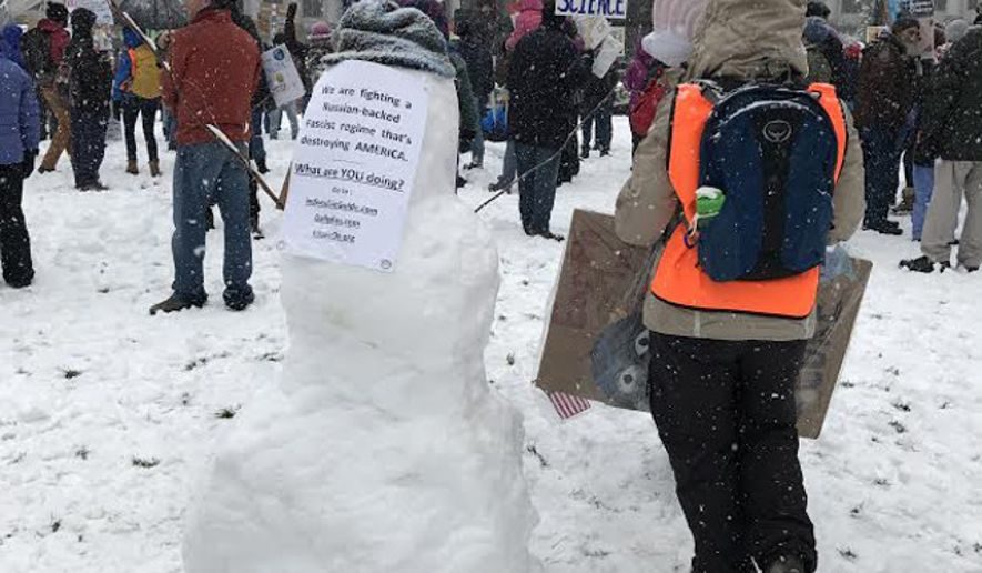
More than 100 marchers braved the cold at a rally Saturday at Civic Center Park in Denver, where the snow was so heavy that someone was able to build a snowman, as shown in photos posted online.

The website Complete Colorado ran a photo of a man on skis with the headline, "Heading to the Global Warming Rally Today."

Snowflake

8 inches of snow hits Denver, Colorado

 snow falls in the foothills outside of Denver
Snow near Denver
The Denver metro area saw 2-8 inches of snow overnight as flakes continued to fall in the morning.

Snow began falling along the Front Range Friday, hitting the Palmer Divide area in the afternoon and downtown Denver by the evening commute. The snowfall should stop across the metro area Saturday morning without much accumulation, National Weather Service meteorologist Jim Kalina said. The other side of the Palmer Divide could see snow into the evening.

Saturday's temperatures should hang in the mid-30s, dropping down to the lower to mid-20s at night. Many parts of Denver are likely to experience a hard freeze. Sunday will bring some relief with sunny skies and highs around the lower to mid-50s, Kalina said.

Comment: See also this report concerning the surrounding region: Latest Totals: Storm Dumps Over Foot Of Snow Near Denver


Snowflake

Spring snow for Colorado: 4 to 15 inches expected in Denver, Boulder

Colorado snow forecast
© CBS News - Denver
As only CBS4 told you last night, Denver would see a beautiful start to Friday - and we were greeted to a cloudless blue sky as temperatures warmed to a high of 54 degrees. Then the weather began to change as a storm system tracking across the Four Corners region and then over New Mexico began producing a strong upslope flow along the Front Range changing rain over to snow.

As a result, the Denver and Boulder areas are under a Winter Storm Warning from 6 p.m. Friday until 6 p.m. Saturday for 4-12 inches of slushy snow. The higher amounts will be over the southern suburbs in Arapahoe County and northern Douglas County.

Locations farther south and west are also under a Winter Storm Warning from 4 p.m. Friday until 6 p.m. Saturday for 8-15 inches of snow. This includes the foothills of Jefferson, Boulder, and Larimer Counties as well as the Palmer Divide in Douglas and Elbert Counties. The biggest impact in these areas may be damaged tress and power lines due to the weight of the heavy, very wet snow.

Heavy snow will also impact southern Colorado. A Winter Storm Warning is in effect for the I-25 corridor south of Pueblo including Walsenburg, Trinidad, and Raton Pass in northern New Mexico. The Sangre de Cristo Mountains will likely see 1-2 feet of snow.