Earth ChangesS


Cloud Precipitation

2 years on: Hurricane Sandy inspires storm of climate research

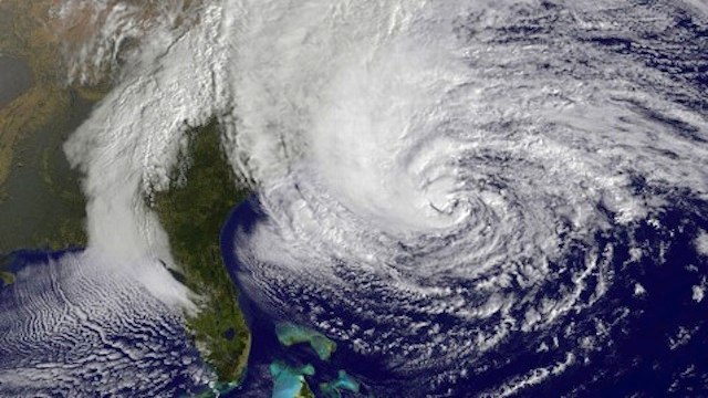
Hurricane Sandy
© www.vanityfair.comNortheast's epic storm, Hurricane Sandy
The two years that have passed since Hurricane Sandy crashed into the New Jersey shoreline have not been enough time for scientists and researchers to make much headway on the hows and whys of the Northeast's epic storm. But that's not because they aren't trying.

In fact, Sandy has spurred an unprecedented amount of research, attempting to tackle the questions about what role climate change might have played in producing or worsening the storm, how global warming might influence similar storms in the future, and why the storm caused so much damage - $19 billion in the New York City area alone. "It'll be one of the most studied storms," said Gary Lackmann, an atmospheric scientist at North Carolina State University who has looked into the role warming might have played in guiding Sandy's track and intensity.

Here, Climate Central takes a look at some of those research avenues exploring the role climate change played in Sandy and how the so-called superstorm impacted our evaluation of current and future coastal risks.
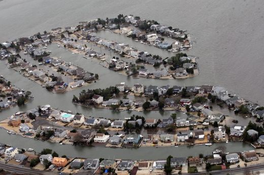
flooded
© www.pressofatlanticcity.comAtlantic City during temporary sea rise.
Of Sea Level Rise and Storm Surge

The clearest connection between climate change and Sandy's impacts is sea level rise. Warming oceans and melting land ice have contributed in large part to the nearly 12 inches of sea level rise in the New York area over the past 100 years, a rate faster than the global average of about 8 inches.

Sea level rise is contributing to coastal erosion in some places such as the Jersey Shore, but Philip Orton, an oceanographer at the Stevens Institute for Technology in Hoboken, N.J., said that how it interacted with storm surge - the wall of water that hurricanes and other storms push ashore - is what helped drive much of Sandy's damage. And the future 1-2 punch of storm surge and sea level rise could further reshape the physical and social landscape around New York and New Jersey. "Sea level rise is very uncertain so that's part of the problem for long-term planning," Orton said.
Comment: Due to a negative phase, in the constantly changing pressure gradient of the North Atlantic Oscillation (NAO), a high pressure ridge over Greenland blocked Sandy's NE trajectory. Plus, a dip in the jet stream and a surface cold front turned Sandy westward into the U.S. East Coast. How does that work?

A high pressure over Greenland creates a counterbalanced low pressure zone to the south and causes colder weather patterns in lower latitudes. Global ocean oscillations, contributing their cyclic and alternating patterns of "highs" and "lows, influence east-west wind troughs and cause or contribute to continental droughts, floods, extreme temperature fluctuations and migrations of wildlife habitats. The extreme swings of the NAO are part of the complex atmospheric/ocean dynamics of the North Atlantic, which include sea-surface temperature anomalies, the strength of the Gulf Stream, atmospheric wave structure and the distribution of sea ice and icebergs. A statistical relation between Arctic Sea ice loss and occurrences of the negative (blocked) NAO phase has been observed in recent decades. A northern high pressure zone increases temperatures causing ice melt. These interactions are poorly understood in reference to their magnitude of effect over contributing systems, vast distances and time.

Add in the following: Ocean warming due to plate tectonics, increasing methane release, a slowing earth rotation creating friction between the mantle and the crust uping earthquakes and volcanic activity, a rise in electrical phenomenon and interaction in the solar system, tropical climate zones measurably moving towards the poles* pushing more warm moisture into higher atmospheres of frigid temperatures resulting in massive winter storms...a recipe for the rapid onset of vast amounts of ice and snow. (Every drop of water creates 10 times its volume upon freezing.)

*According to NOAA, a poleward shift of mid-latitude storms (as in Sandy) is occurring. Are we on track for the next ice age? Is it only a matter of time and confluence?


Cloud Precipitation

1,500 evacuated due to flooding in Buenos Aires

Image
A cold front moving northward across Argentina, Uruguay and southern Brazil has triggered thunderstorms, strong winds and heavy rain over the last few days. Flooding in Buenos Aires province in Argentina has forced over 1,500 people to evacuate their homes. Storms have also caused power outages and damage to property.

In Buenos Aires Province, areas worst affected by the flooding so far include La Matanza (part of Greater Buenos Aires city) where over 1,000 have been evacuated, and the city of Pilar, where 200 have evacuated. For a full list of affected areas, see the list here.

Cloud Precipitation

NASA sees Tropical Cyclone Nilofar being affected by wind shear

Image
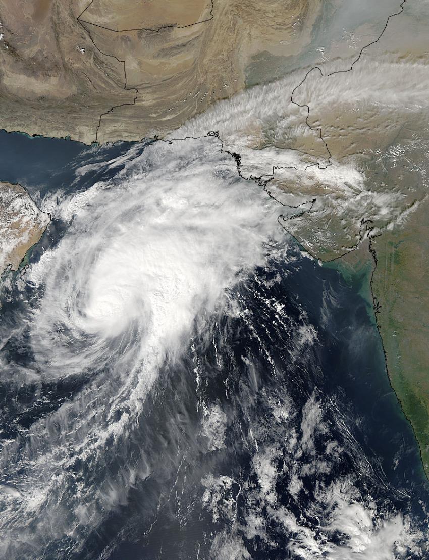
© NASA Goddard MODIS Rapid Response TeamNASA's Aqua satellite captured this image on Oct. 29 at 09:00 UTC (5 a.m. EDT) as Tropical Cyclone Nilofar moved through the Arabian Sea toward a landfall in northwestern India.
Wind shear has kicked in and has been pushing clouds and showers away from Tropical Cyclone Nilofar's center. NASA's Aqua satellite captured an image that showed the effects of the shear on Oct. 29.

The Moderate Resolution Imaging Spectroradiometer aboard NASA's Aqua satellite captured an image of Tropical Cyclone Nilofar on Oct. 29 at 09:00 UTC (5 a.m. EDT). Tropical Cyclone Nilofar is moving through the Arabian Sea. The image shows that clouds were being pushed to the northeast of the center of the storm, from strong southwesterly wind shear.

On Oct. 29 at 1500 UTC (11 a.m. EDT), Nilofar had maximum sustained winds near 90 knots (103.6 mph/166.7 kph) and slow weakening is expected over the next couple of days. Nilofar was centered near 19.5 north latitude and 62.5 east longitude, about 205 nautical miles (236 miles/380 km) east-southeast of Masirah Island. Nilofar was moving to the north-northeast at 6 knots (6.9 mph/11.1 kph).

Cloud Precipitation

Cyclone Nilofar targeting India's Gujarat State, Southern Pakistan

Image
After becoming impressively strong on Tuesday, Cyclone Nilofar has begun to weaken. Nilofar is expected to head towards southeastern Pakistan and northwestern India, with landfall likely on Saturday.

On Tuesday afternoon, Nilofar intensified to the equivalent of a hurricane with estimated wind speeds of 130 mph, according to the U.S. Joint Typhoon Warning Center, about 650 miles south-southwest of Karachi, Pakistan. Nilofar underwent rapid intensification, and became the third strongest tropical cyclone of record in the Arabian Sea.

Only Gonu in 2007 (Cat. 5; 165 mph winds) and Phet in 2010 (Cat. 4; 145 mph winds) were stronger Arabian Sea tropical cyclones in the historical record, according to Masters.

Arrow Down

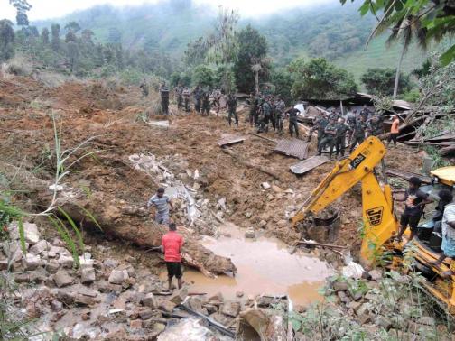
More than 100 believed dead in Sri Lanka landslide after heavy monsoon rain

Image
© REUTERS/StringerRescue teams from the Sri Lankan military engage in rescue operation work at the site of a landslide at the Koslanda tea plantation in Badulla October 29, 2014.
A landslide in hilly south-central Sri Lanka is believed to have killed more than 100 people on Wednesday as it buried scores of houses, a government minister said, and the toll is likely to rise.

The landslide hit a village in the tea-growing area of Sri Lanka after days of heavy monsoon rain, with more than 300 people listed as missing.

"More than 100 people are believed to have died," Disaster Management Minister Mahinda Amaraweera told Reuters from the disaster site in the village of Haldummulla, 190 km (120 miles) inland from the capital, Colombo.

"We have suspended the rescue operations because of darkness and inclement weather. There is also a threat of further landslides."


Attention

Dead humpback whale found on Kapiti Coast, New Zealand

Image
© David HaxtonIwi perform a karakia by the dead humpback whale on Waikanae Beach.
A 10 metre-long humpback whale has washed up dead on Waikanae Beach early this morning.

Department of Conservation spokeswoman Jane Dobson said they received reports of the stranding, south of Waikanae Boat Club, around 6.30am.

"It's been confirmed that it's a humpback whale, approximately 10 metres long and estimated to be about 25 to 30 tonne.

"Senior ranger Brent Tandy has said that its smaller size suggests it's not fully mature."

Ms Dobson said it was unknown how the whale had died, but it appeared to have been dead for some time.

Cloud Precipitation

Hundreds evacuated after major floods hit western Norway

Image
© Arne Sandvold / twitterFlam, Norway, October 2014.
After 2 days of heavy rainfall, parts of western Norway suffered major flooding after rivers overflowed in the counties of Sogn og Fjordane and Hordaland late on Tuesday 28 October 2014. Heavy rain has also continued to affect parts of Rogaland county.

Initial reports suggest that Odda and Voss in Hordaland and Flåm, Laerdal, Årdal and Stryn in Sogn og Fjordane have been the worst affected.

The heavy rainfall has also led to avalanches in some areas of western Norway.


Ice Cube

North Pole becomes covered in ice in 8 days - video

Image
North Pole
South Pole still at record levels

........................................................................................................................

8 days ago, dutchsinse put out a video showing that the North Pole Ice pack was growing rather rapidly.


After doing some mileage computations on the spread of the ice, dutchsinse made the statement that the North Pole would be covered in a couple weeks (or less).

Thanks to Marcus Adrian for this video

Nuke

Mass die offs of Sitka sea stars recorded, Alaska

Image
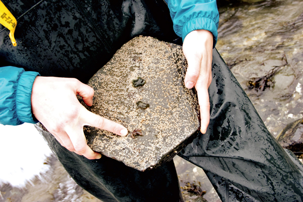
© Anne Brice/KCAWTaylor White pulls up a rock on Sage Beach to see three leptasterias, which are small, 6 legged sea stars that are common at this site. She points to the one with three legs and lesions, symptoms of sea star wasting disease.
A trip to the coast usually means you're going to see sea stars, but a mysterious disease is killing them along the West Coast. There had been a few reports of sick sea stars in Alaska, but recently in Sitka, the first mass die offs in the state were detected. Scientists in Sitka are tracking the progress.

Patty Dick lives on a boat in Thompson Harbor in Sitka. In the morning, when it's low tide and she has an extra moment, she goes out and checks on the sea stars living in the area.

"I just sit there in awe of the beauty of that animal," she said. "Everybody loves sea stars."

Dick teaches 6th grade biology at Blatchley Middle School. She often takes her students on field trips to learn about marine animals, and they usually find dozens of sea stars.

But one morning last month, Dick noticed something was wrong with the sea stars. "I just looked over and I just stopped. There were these big, huge, white spots all over them and they were just wasting away. My heart just sank."

Bizarro Earth

Idiocracy: Japan reacts to Fukishima disaster by re-opening nuclear plant right next to active volcano

D'oh!

Scientists warned that an earthquake could take out Fukushima. The Japanese ignored the warning ... and even tore down the natural seawall which protected Fukushima from tidal waves.

Fukushima is getting worse. And see this and this.

Have the Japanese learned their lesson? Are they decommissioning nuclear plants which are built in dangerous environments?

Of course not!

Instead, they're re-starting a nuclear plant near a volcano which is about to blow ...

A month ago, there was an eruption at Mt. Ontake:
Mt. Ontake
Screenshot from Youtube Video shot on September 29th of Mount Ontake erupting. 57 hikers were killed by the explosion