Earth ChangesS


Attention

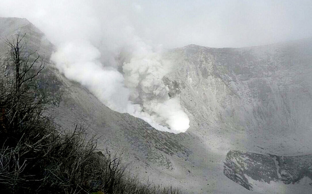
Costa Rica volcano spews ash in biggest erruption for 100 years

Turrialba volcano in Costa Rica
© OVSICORI/AFPSteam and ash spews from a vent inside the crater of the Turrialba volcano in Costa Rica.
The biggest eruption in a century at a volcano in Costa Rica has rained ash over the Central American country and prompted authorities to evacuate some communities.

Emergency services and scientists remained on high alert on Friday after the overnight explosion at the Turrialba volcano, close to the capital San Jose.

Volcanologist Gino Gonzalez said that the volcano had been rumbling and producing seismic activity since Wednesday evening.

He said the explosion caused the side of the crater to collapse, and ashfall was recorded in four provinces.

Sherlock

More GMO contamination: USDA skeptical over GMO wheat mishaps

Image
© truthstreammedia.comWhile GMO wheat is not currently on the U.S. market, that does not mean it isn't being grown here.
The discovery of another unapproved variety of genetically modified wheat in Montana has increased pressure to tighten the regulation of biotech crops, a change that could cause havoc for farmers in Iowa and across the U.S. eager to get their hands on the newest varieties.

The popular crops are staunchly defended by farmers who depend on genetically altered seeds to provide them with higher yields, better-quality products, and lower consumption of chemicals to rebuff attacks from weeds or insects. The result is a boon to their bottom line.

The United States is by far the world's largest grower of biotech crops, planting 173 million acres in 2013 - almost 4% of all biotech acreage globally. In Iowa, 95% of all corn planted this year came from genetically engineered seeds.

But food and environmental groups are skeptical about the safety of these crops in everyday foods and in the environment in which they grow. The discovery of unapproved wheat has renewed calls for regulators to adopt a slower, more stringent approval process.

Comment: "I would hope that USDA would use this as an opportunity to do some research about the efficacy of their field trail conditions that they put in place"

Wishful thinking Greg Jaffe! The whole idea behind biotechnology is to mass contaminate, it's the norm, once GMO seeds are in nature they take over, they are bred to survive toxic herbicides, and contrary to Jaffe's statement, these isolated incidences do have food safety and environmental impacts:
The greater truth is that Monsanto is itself a corporation of global sabotage that destroys agriculture, contaminates the planet with genetic pollution, threatens farmers with lawsuits for planting common seeds, and then blames activists when its own dangerous experiments go haywire.
Biotech crop supporters claim there has been plenty of research done, and so-called isolated incidents like this, cast a cloud over the benefits of biotechnology. The reality?
science-based requirements for field trials, is seriously lacking! There will be no additional oversight, mainly because federal regulators, like the USDA, are on the same team as Monsanto:

Monsanto: 'There is no need for, or value in testing the safety of GM foods in humans'
Monsanto does not actually care about science, though, and has actually made it a point to just arbitrarily deny the need for actual GMO testing in humans to prove its claims. In concluding its unsubstantiated diatribe about why human testing of GMOs is unnecessary, the agri-giant says there is simply "no need, or value" in testing the safety of GMOs - in other words, if Monsanto says they are safe, then they are safe!
The fact that anyone considers this blind, self-serving declaration to be scientifically sound is frightening in and of itself, let alone the fact that the US government openly approves of such nonsense and has used it to form food policy. To put it more simply, GMOs have never been properly safety tested in humans because Monsanto does not feel it is necessary, and most of those in control of food policy are perfectly content with this.


Wolf

Thousands treated for animal bites in Cumbria as pets turn nasty, UK

Hospital medics in north Cumbria have faced a flood of patients bitten by their pets, with more than 18,000 treated over the last five years.

Image
Ouch: Terry Bowes from Wetheriggs Animal Rescue Centre with a tarantula. ‘Spiders and reptiles can never be fully domesticated’ he warns
The staggering statistic has been revealed by the NHS trust which runs the Cumberland Infirmary in Carlisle and Whitehaven's West Cumberland Hospital.

While the benefits of pet ownership are well documented, the figures - released in response to a Freedom of Information request - show the potential dangers.

Health

Baby awaits surgery after rat attack in South Africa

Image
© WikipediaA 3-month-old awaits surgery after being attacked by rats in her Alexandra home.
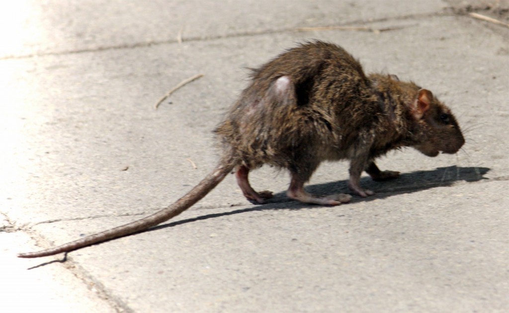
A one month-old baby whose three fingers and part of a nose were eaten by rats in Alexandra, Johannesburg is awaiting surgery as her family cannot afford it.

The rats attacked Erena Yekanyi at her home last Monday, The New Age reported on Wednesday.

"I was washing outside while Erena was sleeping inside the house. I heard her cry and when I ran into the house, I found her covered in blood," the baby's mother, Thandaza reportedly said.

The baby would continue to await reconstructive surgery at Charlotte Maxeke Academic Hospital until her mother was able to raise funds for the procedure.

The attack was not the first in the township, according to the report.

Comment: See also: Brooklyn mother says rat bit her young son while he slept


Fish

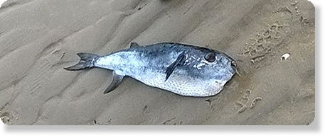
Poisonous tropical puffer fish found dead on Dutch island beach

Image
The puffer found on Hors
A dead puffer fish has been found washed up on the beach of the Wadden Sea island of Texel.

The bizarre find was made by staff of the Ecomare marine centre during a walk. The fish, 51 centimetres long, has the latin name Lagocephalus lagocephalus and is only found in tropical and sub-tropical eastern Atlantic waters.

'It was a real tropical surprise,' Ecomare workers Pierre Bonnet and Arthur Oosterbaan said on the organisation's website.

Cloud Precipitation

Flooding in Democratic Republic of Congo leaves at least 30 dead

Image
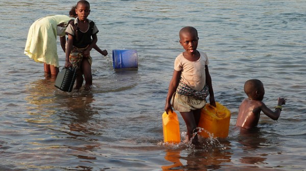
© EU/ECHO/Damien Blanc River in South Kivu.
At least 30 people have been killed by recent flooding and landslides in the Democratic Republic of Congo with many more thought to be still missing.

The disaster struck in Kalehe Territory in South Kivu province after 3 days of heavy rain. The village of Bushushu is said to be the worst hit. Local media say that other villages in the area, including Rambira, Nyambasha and Nyamukubi have also been badly affected.

With so many still missing, there are fears that the floods and landslides may have killed over 100 people. Bodies are buried under landslide rubble or have been swept away on flood torrents, possibly as far as Lake Kivu, where local fishermen are assisting with the search. Hundreds of homes and other buildings, as well as bridges and roads in and around the village have been damaged or destroyed by flood or landslides.

Cloud Precipitation

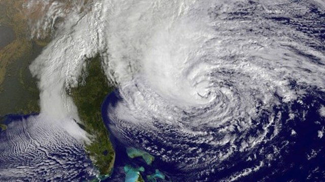
2 years on: Hurricane Sandy inspires storm of climate research

Hurricane Sandy
© www.vanityfair.comNortheast's epic storm, Hurricane Sandy
The two years that have passed since Hurricane Sandy crashed into the New Jersey shoreline have not been enough time for scientists and researchers to make much headway on the hows and whys of the Northeast's epic storm. But that's not because they aren't trying.

In fact, Sandy has spurred an unprecedented amount of research, attempting to tackle the questions about what role climate change might have played in producing or worsening the storm, how global warming might influence similar storms in the future, and why the storm caused so much damage - $19 billion in the New York City area alone. "It'll be one of the most studied storms," said Gary Lackmann, an atmospheric scientist at North Carolina State University who has looked into the role warming might have played in guiding Sandy's track and intensity.

Here, Climate Central takes a look at some of those research avenues exploring the role climate change played in Sandy and how the so-called superstorm impacted our evaluation of current and future coastal risks.
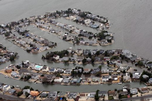
flooded
© www.pressofatlanticcity.comAtlantic City during temporary sea rise.
Of Sea Level Rise and Storm Surge

The clearest connection between climate change and Sandy's impacts is sea level rise. Warming oceans and melting land ice have contributed in large part to the nearly 12 inches of sea level rise in the New York area over the past 100 years, a rate faster than the global average of about 8 inches.

Sea level rise is contributing to coastal erosion in some places such as the Jersey Shore, but Philip Orton, an oceanographer at the Stevens Institute for Technology in Hoboken, N.J., said that how it interacted with storm surge - the wall of water that hurricanes and other storms push ashore - is what helped drive much of Sandy's damage. And the future 1-2 punch of storm surge and sea level rise could further reshape the physical and social landscape around New York and New Jersey. "Sea level rise is very uncertain so that's part of the problem for long-term planning," Orton said.
Comment: Due to a negative phase, in the constantly changing pressure gradient of the North Atlantic Oscillation (NAO), a high pressure ridge over Greenland blocked Sandy's NE trajectory. Plus, a dip in the jet stream and a surface cold front turned Sandy westward into the U.S. East Coast. How does that work?

A high pressure over Greenland creates a counterbalanced low pressure zone to the south and causes colder weather patterns in lower latitudes. Global ocean oscillations, contributing their cyclic and alternating patterns of "highs" and "lows, influence east-west wind troughs and cause or contribute to continental droughts, floods, extreme temperature fluctuations and migrations of wildlife habitats. The extreme swings of the NAO are part of the complex atmospheric/ocean dynamics of the North Atlantic, which include sea-surface temperature anomalies, the strength of the Gulf Stream, atmospheric wave structure and the distribution of sea ice and icebergs. A statistical relation between Arctic Sea ice loss and occurrences of the negative (blocked) NAO phase has been observed in recent decades. A northern high pressure zone increases temperatures causing ice melt. These interactions are poorly understood in reference to their magnitude of effect over contributing systems, vast distances and time.

Add in the following: Ocean warming due to plate tectonics, increasing methane release, a slowing earth rotation creating friction between the mantle and the crust uping earthquakes and volcanic activity, a rise in electrical phenomenon and interaction in the solar system, tropical climate zones measurably moving towards the poles* pushing more warm moisture into higher atmospheres of frigid temperatures resulting in massive winter storms...a recipe for the rapid onset of vast amounts of ice and snow. (Every drop of water creates 10 times its volume upon freezing.)

*According to NOAA, a poleward shift of mid-latitude storms (as in Sandy) is occurring. Are we on track for the next ice age? Is it only a matter of time and confluence?


Cloud Precipitation

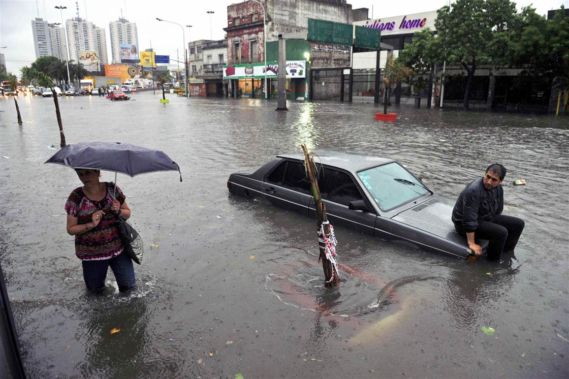
1,500 evacuated due to flooding in Buenos Aires

Image
A cold front moving northward across Argentina, Uruguay and southern Brazil has triggered thunderstorms, strong winds and heavy rain over the last few days. Flooding in Buenos Aires province in Argentina has forced over 1,500 people to evacuate their homes. Storms have also caused power outages and damage to property.

In Buenos Aires Province, areas worst affected by the flooding so far include La Matanza (part of Greater Buenos Aires city) where over 1,000 have been evacuated, and the city of Pilar, where 200 have evacuated. For a full list of affected areas, see the list here.

Cloud Precipitation

NASA sees Tropical Cyclone Nilofar being affected by wind shear

Image
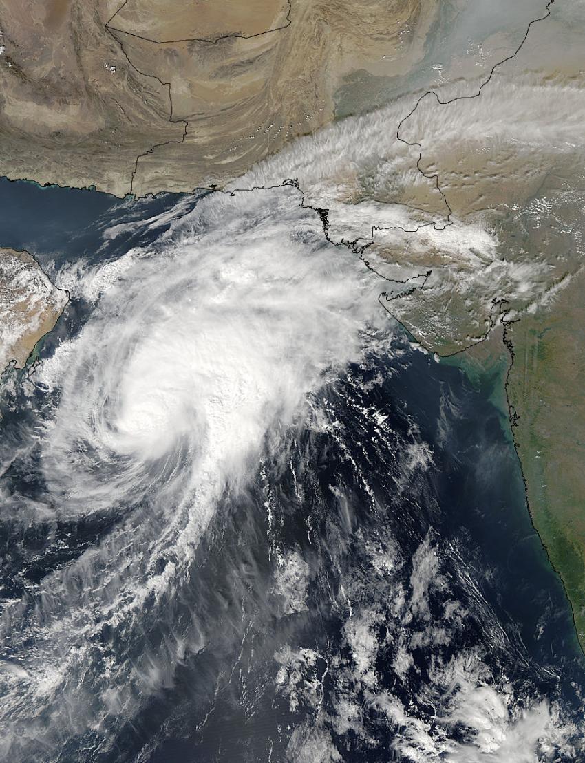
© NASA Goddard MODIS Rapid Response TeamNASA's Aqua satellite captured this image on Oct. 29 at 09:00 UTC (5 a.m. EDT) as Tropical Cyclone Nilofar moved through the Arabian Sea toward a landfall in northwestern India.
Wind shear has kicked in and has been pushing clouds and showers away from Tropical Cyclone Nilofar's center. NASA's Aqua satellite captured an image that showed the effects of the shear on Oct. 29.

The Moderate Resolution Imaging Spectroradiometer aboard NASA's Aqua satellite captured an image of Tropical Cyclone Nilofar on Oct. 29 at 09:00 UTC (5 a.m. EDT). Tropical Cyclone Nilofar is moving through the Arabian Sea. The image shows that clouds were being pushed to the northeast of the center of the storm, from strong southwesterly wind shear.

On Oct. 29 at 1500 UTC (11 a.m. EDT), Nilofar had maximum sustained winds near 90 knots (103.6 mph/166.7 kph) and slow weakening is expected over the next couple of days. Nilofar was centered near 19.5 north latitude and 62.5 east longitude, about 205 nautical miles (236 miles/380 km) east-southeast of Masirah Island. Nilofar was moving to the north-northeast at 6 knots (6.9 mph/11.1 kph).

Cloud Precipitation

Cyclone Nilofar targeting India's Gujarat State, Southern Pakistan

Image
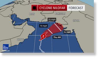
After becoming impressively strong on Tuesday, Cyclone Nilofar has begun to weaken. Nilofar is expected to head towards southeastern Pakistan and northwestern India, with landfall likely on Saturday.

On Tuesday afternoon, Nilofar intensified to the equivalent of a hurricane with estimated wind speeds of 130 mph, according to the U.S. Joint Typhoon Warning Center, about 650 miles south-southwest of Karachi, Pakistan. Nilofar underwent rapid intensification, and became the third strongest tropical cyclone of record in the Arabian Sea.

Only Gonu in 2007 (Cat. 5; 165 mph winds) and Phet in 2010 (Cat. 4; 145 mph winds) were stronger Arabian Sea tropical cyclones in the historical record, according to Masters.