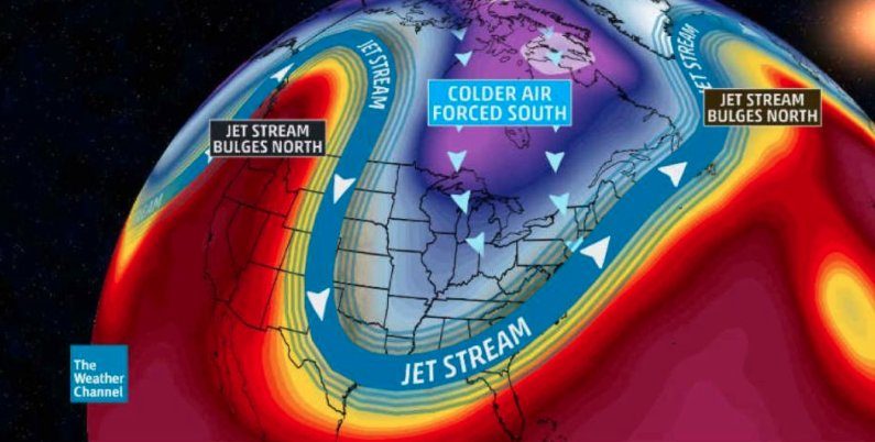
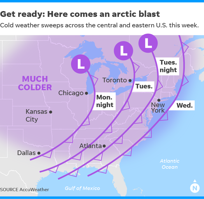
Frigid temperatures, but little snow, will hit from the Midwest to the Southeast. Even parts of Florida will see nighttime temperatures dip into the 30s.
Unlike previous cold snaps this fall, this one looks to stay around for a while, potentially until the first day of winter on Dec. 21, AccuWeather meteorologist Max Vido said.
Comment: Just a few weeks ago in the middle of November the US was blasted by Arctic cold. This weather pattern is becoming the norm: US: Polar vortex to bring 'extended period of severe winter weather', amidst already record breaking cold
The high temperatures later this week will be about 20 to 30 degrees colder than they are Monday, according to AccuWeather, with highs near 40 degrees in the Northeast and 50 degrees as far south as Atlanta.
After unusually warm temperatures in the mid-50s on Monday, Minneapolis may not rise above freezing for the next two weeks, according to weather.us meteorologist Ryan Maue.
For most areas, snow will not accompany the cold. The heaviest snow will be confined primarily to the northern Plains and around the Great Lakes over the next few days.
In the short term, blizzard warnings have been posted for parts of the eastern Dakotas and northwest Minnesota where snow and wind gusts up to 55 mph will create dangerous travel conditions into Monday evening, the National Weather Service said. The heavy snow will expand into parts of the Upper Great Lakes overnight Monday and early Tuesday.
After this storm moves away, the snow focus shifts to the lake-effect variety, which will hit the typical snow belt areas of Michigan, Ohio, Pennsylvania and New York State with significant snowfall.
"Places that will pick up the heaviest snow are the Tug Hill Plateau downwind of Lake Ontario, the south towns of Buffalo, and northern Michigan," AccuWeather meteorologist Steve Travis said. Some places could see more than two feet of snow, the weather service said.
Later in the week, a storm forecast to bring rain to the Southeast coast could turn northward and graze the Northeast coast with snow or rain.
While the central and eastern U.S. shivers, folks in southern California and the Southwest will endure hot, dry Santa Ana winds this week, which could spread wildfires.
This will be the strongest, longest-duration Santa Ana event of the season, the weather service in Los Angeles warned, with some gusts of up to 80 mph possible.
"Extremely critical fire weather conditions will be the primary concern as we've received very little rain so far and fuels are parched and primed to burn with even the slightest ignition source," the weather service said.
Comment: We're witnessing a similar weather pattern in Europe:
A few years ago 'Arctic blasts' and 'polar vortex' situations were uncommon and yet we're now seeing them happening every winter, and sometimes more than once and hanging around for weeks. This, along with many other unusual and rare events, is indicative of the changes occurring on Earth, and that our climate is entering an Ice Age:
- Ice age on the way: Gulf Stream is slowing down faster than ever, scientists say
- Siberian snow theory points to early, frigid winter in U.S.
- Temperatures in Siberia dropping to -79°F/-60°C and winter is just beginning
- Return of the Polar Vortex? Arctic Cold Setting Dozens of Daily Records in the Northeast and Midwest


Reader Comments
to our Newsletter