Storms
S

Bizarro Earth

Tropical Storm Debby Breaks Record with Early Debut

Tropical Storm Debby
© NOAAA ghostly Tropical Storm Debby is drenching Florida and surrounding regions.
An unusually early spate of tropical storms has been keeping forecasters busy this year, and now Tropical Storm Debby, the fourth named storm of the Atlantic hurricane season, has set a record - this season marks the first time in more than 150 years that so many storms have showed up so early.

"This is first time we've had four tropical storms develop in the Atlantic basin before July 1," said Dennis Feltgen, a meteorologist and spokesman for the National Hurricane Center in Miami, Florida.

U.S. records for tropical storms and hurricanes stretch back to 1851, Feltgen told OurAmazingPlanet. And although Tropical Storm Debby has broken the century-and-a-half-long record, there is certainly a chance that four storms may have formed this early in the past, yet escaped notice simply because forecasters didn't have the tools to see them.

"We figure that back in the day there could have been several storms per season that could have been missed," Feltgen said. "We didn't have satellites." Forecasters relied largely on ship reports and on firsthand observations when a storm hit land.

Cloud Lightning

Deadly British Columbia flooding continues to prompt evacuations, highway closures

Image
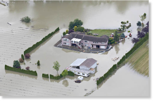
© Andy Clark, ReutersA house is surrounded by water after the Fraser River burst its banks in Chilliwack, British Columbia June 24, 2012. Authorities have issued an evacuation order for 165 homes in Fraser Valley.
Hundreds of British Columbians are away from their homes, others are without clean drinking water and one person is dead after a weekend of heavy rain flooded homes and washed away roads in several areas of the province.

Weeks of rapid snowmelt and wet weather have caused river levels to rise in the B.C. Interior, the Kootenay region and the Fraser Valley, and a weekend of heavy rain and violent thunderstorms have pushed many rivers and creeks in those areas to the brink.

Hardest hit was Sicamous, a community of about 3,100 people north of Kelowna, where about 350 people were ordered to leave their homes due to flooding along the Sicamous and Hummingbird creeks.

At least one home was swept away, and many more homes and dozens of cars were damaged after flash floods tore through Sicamous, where the local district declared a state of emergency.

"It's total devastation and disaster," said 65-year-old Judy Latosky, who saw Sicamous Creek spill its banks before fleeing her home with her twin five-year-old granddaughters.

"Parts of the bank were just falling off in chunks. We lost all of our backyard and now it's just boulders. ... I looked in this morning and the basement is half full of mud and water. It's a total loss."

More pictures

Bizarro Earth

Three villages buried in Uganda by landslide on slopes of Mt. Elgon- 100 feared dead

Image
© Unknown
Many people were feared dead after villages were buried in a landslide on Monday in eastern Uganda on the slopes of Mt. Elgon, which straddles the Kenyan border.

Some media reports said about 10 people had been killed in the landslide while the area member of parliament, David Wakikona, told Reuters that up to 100 people could have been buried. This could not be independently verified.

"Three villages have been flattened in the Bumwalukani parish on the slopes of Mt. Elgon and the initial reports I have is that more than 100 have been buried," he said.

Cloud Lightning

Sunshine State's Potential Debby Deluge

Image
© WeatheChannel.com
Last week we began discussing the potential for a depression or named storm to form over the Gulf of Mexico or western Caribbean later this week or weekend.

A enhanced pulse of thunderstorms, triggered by the Madden-Julian Oscillation, has arrived in the eastern Pacific, central America and the western Caribbean Sea from off southeast Asia and the Indian Ocean. Out of this spun up Hurricane Carlotta, which sliced into southern Mexico last week.

Now, winds aloft over the Gulf of Mexico are forecast to become more favorable for low pressure to form and consolidate at least sufficient convection to be deemed either a tropical depression or tropical storm ("Debby" is the next named storm in the list), possibly as soon as late Friday.

Cloud Lightning

Flood fear after rain forecast for North and Mid-Wales

Image
© UnknownParts of mid Wales saw the worst flooding in generations earlier in June
Parts of mid and north Wales have been warned they may be at risk of localised flooding as more heavy rain is forecast.

Downpours are expected on Friday and are likely to continue into Saturday, Environment Agency Wales said.

It added that recent rainfall in the area means rivers may rise quickly and that it may lead to flood warnings.

Agency officers are checking flood defences and that rivers and streams are clear of blockages.

Devastating floods hit parts of mid and north Wales earlier this month after extreme localised flooding.

Environment Agency Wales said that the latest rain will be heaviest in mid and north Wales.

It said that a concentrated weather system of extremely heavy rainfall is currently forecast for the north west of England, not far from the Welsh border.

"Current predictions indicate that the heaviest rainfall will largely affect English counties, however, there is a risk that the weather system may move, bringing heavier rain into parts of north east Wales," the agency added.

Bizarro Earth

Caribbean System May Spawn Floods From Florida to Caymans

Storm forecasters are tracking a potential tropical weather system that may spawn heavy rain and flooding from the Bahamas and Florida to the Cayman Islands.

The disturbance has a 30 percent chance of organizing and strengthening into a tropical depression or storm in the next two days as it moves northwest into the Gulf of Mexico, the National Hurricane Center in Miami said.

Two days of heavy rain and local flooding may occur across western Cuba, southern Florida, the central Bahamas and Yucatan peninsula, the NHC said. The center is also monitoring Tropical Storm Chris southeast of Newfoundland, the third named storm of the Atlantic hurricane season.

Chris was 630 miles (1,010 kilometers) from Cape Race, Newfoundland, moving east-northeast at 20 mph, the NHC said in its 5 a.m. Atlantic time advisory. Its top winds were 60 mph. Little change in strength is expected with the storm forecast to become post-tropical by the end of the week.

Umbrella

Duluth in State of Emergency after Torrential Rains Sweep City, North Shore

Image
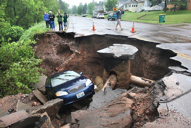
© The Associated Press/The Duluth News-Tribune/Bob KingA car fell into a huge sinkhole in Duluth, Minn. on Wednesday, June 20, 2012.
Major flooding struck in and around Duluth on Wednesday after up to 10 inches of rain fell overnight across northeastern Minnesota, leaving neighborhoods isolated, zoo animals drowned and state parks closed.

Steady, torrential rain kept up into Wednesday morning, June 20, closing Interstate 35 and a tunnel into downtown Duluth. Police said sinkholes and washouts made travel dangerous.

Residents of the far west Duluth neighborhood of Fond du Lac, near the rising St. Louis River, were asked to leave their homes. Seventy people arrived at shelters opened by the Red Cross, officials said.

State emergency management officials set up an operations center in response to the flooding across Aitkin, Carlton, Cook, Lake and St. Louis counties, including the Duluth area.

Gov. Mark Dayton declared a state of emergency and directed the Minnesota National Guard to help the region cope with the disaster.

Dayton planned to travel to Duluth on Thursday morning.

There were no immediate reports of deaths or serious injuries, though an 8-year-old boy was swept about six blocks through a culvert near Duluth. The boy suffered scrapes and bruises but was fine, St. Louis County Undersheriff Dave Phillips said, calling it a "miracle out of this whole disaster."

Minnesota Department of Public Safety officials cited Duluth police reports that half of the Fond du Lac neighborhood was under evacuation and the town of Thomson was partially evacuated.
Arrow Down

Duluth Roads Collapse, Sinkholes Swallow Cars


Minnesota, US - The damage is breathtaking. "The roads are just a disaster around here," Greg Vogt, with Expert Tire in Duluth said.

In and around Duluth, roads collapsed and sinkholes swallowed cars. On East Skyline Drive a car sits 10 feet below the surface of the road, in a massive sinkhole.

Deep water left some vehicles totaled, like a Volvo behind Expert Tire, and a Chevy Tahoe near the interstate.

"Water was all the way up to the retaining wall," Matt Kebhart said, talking about a three-foot wall in front of the interstate.

Kebhart works at an auto body shop on London Road. Behind it, a dumpster sat in a deep pool of standing water. "That dumpster, I don't even know where it came from," he said.

Cloud Lightning

People, animals flee floods in NE Minnesota city

Duluth floods
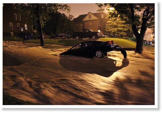
© The Duluth News-Tribune, Andrew KruegerA car is stranded in floodwaters rushing down a hillside in Duluth, Minn., early Wednesday, June 20, 2012. Hours of torrential rainfall have sparked major flooding across the city and along the North Shore of Lake Superior, with some homes being evacuated due to rising water.
Residents evacuated their homes and animals escaped from pens at a zoo as floods fed by a steady torrential downpour struck northeastern Minnesota, inundating the city of Duluth, officials said Wednesday.

Police officers helped track down a polar bear that got out of its enclosure overnight at the low-lying Lake Superior Zoo where several animals drowned.

Duluth Mayor Don Ness declared a state of emergency after the deluge of up to 9 inches of rain that he said caused extensive damage to the port city of about 86,000. Some neighboring communities did the same. Ness said the order would start the process to obtain federal aid, and Gov. Mark Dayton said he would travel to Duluth on Thursday to discuss how the state can help.

Cloud Lightning

11 killed in landslide as heavy rains pound Indonesia

Image
© Unknown
Authorities in eastern Indonesia were searching for a missing 13-year boy Wednesday still missing after a landslide in eastern Indonesia.

"We have recovered 13 people, two of them were still alive and now recovering in hospital. Eleven people are confirmed dead," the head of the regional disaster management body Broery Tjokro told dpa.

The landslide hit a residential area early Tuesday, in Ambon, the capital of Maluku province. The boy was the only person still unaccounted for.