Storms
S

Snowflake

Storm snow totals surge to 5 feet at some Lake Tahoe area ski resorts in 48 hours

Skiers enjoy the fresh powder Saturday at Sierra-at-Tahoe
© Sierra-at-TahoeSkiers enjoy the fresh powder Saturday at Sierra-at-Tahoe
With an additional 2 feet on Friday, snow totals from an ongoing winter storm have surged to 5 feet at some Lake Tahoe ski resorts.

An additional 2 feet could fall Saturday and early Sunday morning
before a winter storm warning expires at noon Sunday.

A winter storm that started Wednesday brought rain to elevations up to 8,000 feet. By Thursday morning snow levels dropped to lake level. On Friday morning resorts reported receiving nearly 3 feet of snow in 24 hours.

Info

Ice Age Farmer Report: Retail food prices pop - Meat as taboo - Hawaiian snow - Decentralized food!

Rare snowfall on low elevation area of Hawaii
"Eat your meat outside, earth-killer!" Former UN calls to banish meat eaters.

Historic snow in Hawaii.

150 homes destroyed by hail in India.

1,600 cattle lost in Yakima.

Whole Foods raising prices. Start growing your own food and forming resilient communities today.


Sources

Snowflake

Adapt 2030 Ice Age Report: Record snowfall, cold and wind speed in Hawaii

A family plays in the snow at Polipoli State Park in Hawaii
© Penny Thomas/FacebookA family plays in the snow at Polipoli State Park in Hawaii.
Hawaii state wide record coldest temperature ever and 191 mph winds highest ever on the Big Island, snow to the lowest elevation ever on Maui, rare thunderstorm warning Kauai and massive 40+foot waves on Oahu. This was a once in at least 150 year storm.


Comment: Historic winter storm hits Hawaii with record-high waves, flooding, extreme winds and rare snow


Cloud Precipitation

Mudslides, snow, and flash floods: An atmospheric river has soaked California

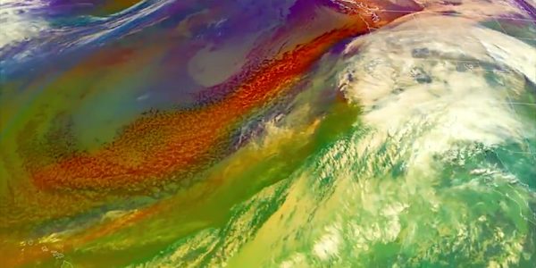
An atmospheric river is channeling moisture near Hawaii toward the West Coast, bringing immense rain and snow.
© NOAAAn atmospheric river is channeling moisture near Hawaii toward the West Coast, bringing immense rain and snow.
A massive, gushing river in the sky โ€” a mile high, more than 300 miles wide, and carrying up to 15 times the amount of water in the Mississippi River โ€” has drenched huge swaths of the West Coast.

This phenomenon, known as an atmospheric river, brought more snow to northern California in a day than parts of New England have seen all winter. Redding, a city in California's Central Valley, got more than 13 inches of snow.


Snowflake

Lake Tahoe ski resorts hit by another 3 feet of snow in 24 hours

snow
Tahoe snow covers vehicle
Mother Nature turned the snow back on Thursday, dumping nearly 3 feet of fresh powder in 24 hours at ski resorts around Lake Tahoe.

Along with dumping deep snow, this winter storm also is causing operational problems at some resorts. Heavenly Mountain Resort is on a delayed opening. Heavenly is planning on opening at 10 a.m. Mt. Rose Ski Tahoe is closed for the day.


Comment: That's another 3 feet to add to this: Lake Tahoe weather: Season snow totals near 400 inches


Cloud Lightning

Lightning strikes kill at least 12 across Uttar Pradesh, India

lightning
© Johannes Plenio
Lightning strikes killed at least 12 people, including four schoolchildren, across Uttar Pradesh on Thursday as many parts of north India were lashed by snow, thunderstorms and hail.

The bad weather left PM Narendra Modi stranded for four hours at Dehradun's Jolly Grant airport in the morning, preventing him from flying to Rudrapur, near Haldwani, for a public rally.

In Delhi, morning showers and hailstorms at isolated places led to the diversion of six flights and left many more delayed. The city saw intermittent showers till evening. Friday is expected to be cloudy with the possibility of light rain or thundershowers.

Tornado2

Impressive gustnado forms in Guatemala

gustnado forms in Guatemala
On 13th February a spectacular gustnado surprised the residents of Sololรก in Guatemala. In a matter of minutes, the phenomenon spread through social networks and the media, due to its unusual character and its large size reports tiempo.

Although widely shared as a tornado or dust devil, the Guatemalan National Institute of Seismology, Volcanology, Meteorology and Hydrology confirmed it was a gustnado.

A gustnado is a short-lived, ground-based swirling wind that can form on the leading edge of a severe thunderstorm.


Snowflake

Adapt 2030 Ice Age Report: West coast USA snow records verify jet stream shift

Two feet of snow
© YouTube/Adapt 2030 (screen capture)
Most snow in 70 year across Seattle and parts of Washington State, Record snow pack Mammoth Mnt, California, new wind record set Mauna Kea Hawaii, tornado in Guatemala mid-winter and more snow n the way to break all totals in Seattle back to 1915. More storm warnings for west coast USA and B.C.


Comment: A couple of years ago scientists reported that Northern Hemisphere jet streams crossed the equator and linked with others in the south. Last year other scientists said a fluctuating jet stream may be causing extreme weather events.

A recent study predicts the next solar cycle phase will bring on a 'Mini Ice Age' as early as 2020, as according to the models, there will be a "huge reduction" in solar activity for 33 years between 2020 and 2053. This will cause global temperatures to decrease drastically.

There is a current lull in solar activity (The sun goes blank for the second time this month in the weakest solar cycle in more than a century). Jet Stream meanderings, and much more, are explained by Pierre Lescaudron in his book Earth Changes and the Human Cosmic Connection:
So since about 1998, when the solar activity started to drop, the Arctic jet stream has shown signs of weakness (lower speed and more southerly location). Jet stream latitudinal oscillations have been acknowledged by mainstream science for years. They are allegedly due to changes in the Arctic oscillation. [561] So far, no convincing explanation has been provided for the causes of this 'oscillation'. However, if the electric nature of our solar system is taken into account, shifts in the jet stream begin to make sense...

Therefore, if solar activity is weak, the jet stream should be observed at abnormally low latitudes. This is what has happened in recent years, particularly over Europe, with the jet stream as low as 15ยฐ north in winter (above North Africa) when it should be around 60ยฐ north (above Scotland)...

In this way, a lasting decrease in solar activity would induce an overall cooling of the 'temperate' latitudes that would be increasingly less separated from Arctic air by a more frequently and abnormally south-shifting polar jet stream. This could be an aggravating factor in the quick onset of an ice age.


Cow

Blizzard kills thousands of Washington dairy cows

dead cows
Dairy farmers in multiple dairying regions of Idaho and Washington experienced significant snowfall, high winds and extreme cold over the weekend, leaving nearly 2,000 dairy cows dead.

According to Matt Gould of Rice Dairy, initial reports from their customers included words like "catastrophic" and "extreme" when it came to describing the impact the snow had on their open lot dairies.

"We heard anecdotes from farmers ranging from losses totaling 100 cows to thousands," he said. "We also heard some milk was dumped because of logistical issues during the storms."

The Yakima Valley Dairy Association says their members lost 1,600 cows in just a few days. The large snowfalls occurred in Grand and Franklin Counties.


Cloud Precipitation

Unseasonal rain damages crops, disrupts lives across Madhya Pradesh, India

crop damage
Intense rain and thundershowers accompanied with hailstorm and strong winds have started lashing several parts of West Madhya Pradesh like Mandsaur and Neemuch. These unseasonal rains have damaged the standing crops that include wheat and mustard.

The danger is not over yet as weathermen are expecting more spells of intense rain and thundershowers over the period of next 48 to 72 hours. Besides, the rain belt is likely to cover more parts of the state gradually. Threat of crop damage looms large as in several areas as the crop is ready to be harvested.

These weather activities can be attributed to the fresh Western Disturbance over Jammu and Kashmir, which has induced a cyclonic circulation over Rajasthan and adjoining areas. With this, wind pattern has also changed and humid easterly and southerly winds are blowing across the northwestern plains.