
Extreme Temperatures
S


Arrow Down

Climate scientists faking data for more funds

The government climate scientists and other academics currently attempting to extort money out of President Trump, are no longer making any effort to maintain any level of plausibility to their lies.

This is their graph.

Fake Data
© The Deplorable Climate Science Blog

Snowflake Cold

Autumn arrives in August over the US & Canada

Cold August across North America
© YouTube/Adapt 2030 (screen capture)
Chilly August begins as temperatures are forecast to be 20F below normal and even in the 35F range for N.E Canada and Rocky Mountain states. This is contrary to the Weather Channels August forecast calling far above normal temperatures through the month. Additionally NY Times article released the same day cites 2003 heat wave in Europe as proof of global warming, but their writers need to understand the Grand Solar Minimum and cosmic rays better to get the full picture.


Comment: Get ready for the Fall? Eastern US to experience unseasonably chilly August


Arrow Down

Coldest day in 19 years for Melbourne, Australia

Melbourne cold temp
Melbourne will be given a chance to thaw out today following the city's coldest day in 19 years on Thursday.

Yesterday's maximum temperature was just 9.0 degrees in Melbourne as the perfect 'cold day scenario' affected the city. The morning started out at just 3.1 degrees after clear skies allowed the mercury plummet during Wednesday night. Thick cloud then drifted over the city blanketed Melbourne throughout the day, limiting the amount of heating from the sun.

Yesterday's maximum temperature was six degrees below the average for August and came in as the city's coldest day for any month since 1998. The last time a maximum temperature that low occurred during August was in 1970, when the mercury only made it 6.8 degrees.

Daily maximum temperatures in Australia are measured as the highest temperature recorded during a 24 hour period between 9am on two consecutive days. This means the city needed to remain below nine degrees until 9am today for Thursday to go down as its coldest August day in almost 50 years.

The statistic came close to being spoilt this morning as the temperature rose to 8.6 degrees at 8:50am and 8.9 degrees at 9am.

Today is forecast to reach a more pleasant top of 13 degrees in Melbourne. While this is still two below average for this time of year, it's balmy compared to yesterday.

Arrow Up

Adriatic Sea temperature record set in Croatia

Mljet, Croatia
© Ivan BagicMljet, Croatia
Whilst heatwave 'Lucifer' has seen a number of air temperature records broken in Croatia over the past few days, record-high sea temperatures have also been set on Saturday.

With air temperatures hovering around 40°C for much of the country, there was not much cooling down going on by jumping into the Adriatic Sea.

According to data from the Croatian Meteorological and Hydrological Service, on Saturday the sea temperature on the southern Dalmatian island of Mljet measured 29.9°C at 5 pm, breaking the current record set on 21 July 2015 on the island of Rab of 29.5°C.

In Dubrovnik today the sea temperature peaked at 27.2°C, whilst it was 28°C in Split, Krk, Rab, and Pula. In Zadar, it was 26°C, whilst Hvar's sea temperature was 27°C on Saturday afternoon.

You can check out the previous highest 11 recorded Adriatic Sea temperatures in Croatia here.

Snowflake Cold

Get ready for the Fall? Eastern US to experience unseasonably chilly August

US August 2017 weather forecast
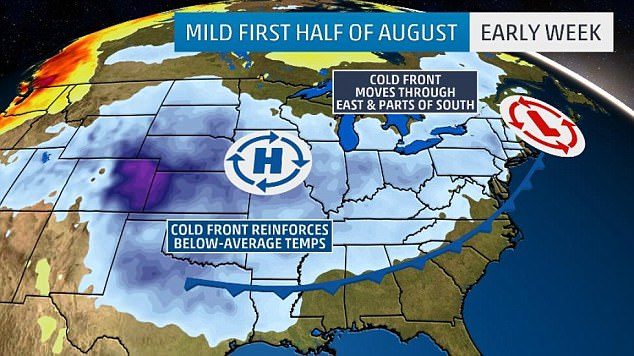
A map shows that a cold front is forecast to sweep across large parts of the country from the east during the first half of August, plunging temperatures below the month's average.
Cooler temperatures are predicted to span much of the eastern part of the United States throughout the month of August.

The first of several spells of below-average temperatures saw shorts exchanged for sweaters across the east of the country over the weekend, with lows of 60F in Chicago and Green Bay on Friday.

Those overnight lows are expected to persist in lands east of the Rockies for the next two weeks, with daytime highs ranging from the upper 70s to the low 80s, according to Weather.com.

Info

Manipulating the southern European heat wave

cloud
With the European "Heat wave" running for the last two weeks, I compared temperatures from 2003, 2006, 2007 and this latest bout of heat. The findings are in line with previous heat during the summer months stretching back to the 1950's. The media is making this to be the hottest ever in Europe, when in fact it is not. plus the media conveniently leaves out the cooler than normal temperatures all along the boundary edges of the heat in central Europe, and not even discussing the below normal temperatures in North Africa. The IPCC machine is steaming ahead full bore.


Sources

Info

Unusual hot and cold temperatures mixing across the Northern Hemisphere

Monarch Pass,  August 4, 2017
© Kim FaheyMonarch Pass, August 4, 2017
With the media focused on a central European heat wave, the conveniently left out of the same temperature map that Norway, Iceland, Sweden, Denmark, Finland and the deserts of N. Africa are below normal temperatures. Also snow in USA in August comes as a surprise, but Al Gore's ascent from $2 million to $300 million is not a surprise.


Sources

Snowflake

It's August and there was snow over Monarch Pass, Colorado

Monarch Pass,  August 4, 2017
© Kim FaheyMonarch Pass, August 4, 2017
If you're reading this, you're likely from Colorado - so you know that when it comes to weather, our beautiful state has quite a few tricks up its sleeve.

Case in point? These photos of Monarch Pass. Yup - it's kinda snowy up there! And the pics are from Aug. 3. That's in the summer.

Brad Shilling lives in Gunnison and took the photos en route to the seasonal state swim championship in Lamar. When they got to the top of the pass, Shilling says rain turned into freezing hail, and then pea-sized hail.

Other cars started to fishtail and lose control in what he described as "slush-snow-rain."

Sun

'Lucifer' heatwave bakes Europe causing scientists to predict massive numbers of deaths by 2100

kids playing in water
© Velar Grant / Reuters
Ten southern and central European countries have declared a red alert after heatwave 'Lucifer' caused temperatures to skyrocket over 40C, with scientists warning that the extreme heat could end up killing 152,000 people a year by 2100.

Italy, Switzerland, Hungary, Poland, Romania, Bosnia-Herzegovina, Montenegro, Croatia, Slovenia, and Serbia are on red alert, European forecast network Meteoalarm said on Saturday.

Florence's famous Uffizi Gallery was temporarily closed on Friday after the museum's air conditioning system broke down, ANSA news agency reported.

Greece, Spain, Bulgaria, France, Macedonia, Slovakia, and Moldova have issued orange alerts to stress the potential for worsening weather conditions.

At least two people have died from the heat, one in Romania and one in Poland, Reuters reported, adding that many more have been taken to the hospital for sunstroke.

"In two hours of my shift today I saw four people fainting on the street and complaining of heat exhaustion," a traffic warden told Reuters in Belgrade.
Arrow Up

Rare 'heat burst' event causes overnight temperature spike in Vacaville, California

Heat burst in Vacaville, California
© National Weather Service
Nightfall didn't bring much relief from the heat for residents in Vacaville thanks to a rare weather phenomenon.

Vacaville suffered through high temperatures of 108 degrees on Thursday, according to the National Weather Service. By 8 p.m., temperatures had dropped down to the low 80s - like what you'd usually expect to happen when the sun goes down.

However, after bottoming out at 80, temperatures actually started to shoot up as the night progressed.

By midnight, temperatures had spiked at 95 degrees.

NWS says the bizarre temperature spike is due to a rare event called a "heat burst."

Much like downburst, a heat burst is usually associated with decaying thunderstorms. Heat bursts are basically the inverse of a downburst - instead of cool and moist air, hot and dry air is rushed toward the surface.