Earthquakes
S


Bizarro Earth

South Sandwich Islands Region - Earthquake Magnitude 6.5

South Sandwich Isld Quake_081210
© USGSEarthquake Location
Date-Time:
Wednesday, December 08, 2010 at 05:24:33 UTC

Wednesday, December 08, 2010 at 03:24:33 AM at epicenter

Time of Earthquake in other Time Zones

Location:
56.440°S, 25.866°W

Depth:
17.3 km (10.8 miles) set by location program

Region:
SOUTH SANDWICH ISLANDS REGION

Distances:
85 km (55 miles) ENE of Visokoi Island, South Sandwich Islands

290 km (180 miles) N of Bristol Island, South Sandwich Islands

3480 km (2160 miles) SE of BUENOS AIRES, D.F., Argentina

Bizarro Earth

Papua New Guinea: Earthquake Magnitude 6.9

Image
© USGS
The U.S. Geological Survey says a powerful earthquake has shaken Papua New Guinea. The agency says the quake had a preliminary magnitude of 6.9 and struck Thursday about 20 miles (32 kilometers) beneath the ocean floor. It hit near the island province of New Britain, 295 miles (470 kilometers) northeast of the national capital Port Moresby.

From USGS:

Date-Time:
Thursday, December 02, 2010 at 03:12:10 UTC

Thursday, December 02, 2010 at 01:12:10 PM at epicenter

Time of Earthquake in other Time Zones

Location:
6.059°S, 149.851°E

Depth:
34.8 km (21.6 miles) set by location program

Region:
NEW BRITAIN REGION, PAPUA NEW GUINEA

Distances:
40 km (25 miles) ENE of Kandrian, New Britain, PNG

65 km (40 miles) SSW of Kimbe, New Britain, PNG

475 km (295 miles) NE of PORT MORESBY, Papua New Guinea

2400 km (1490 miles) N of BRISBANE, Queensland, Australia
Radar

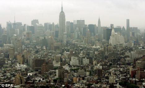
Tremors of earthquake under Atlantic Ocean felt on New York's Long Island

Image
© Environmental Protection AgencyTremors: The earthquake, which measured 3.9 Ritcher Scale, was felt as far away as New York City
An earthquake under the Atlantic Ocean was felt by thousands of U.S. east coast residents yesterday - including people as far away as New York City.

The quake, which was recorded at 10.46am local time, measured 3.9 on the Richter Scale, according to the U.S. Geological Survey.

The event occurred about 80 miles south-east of Southampton, on New York's Long Island, and about 120 miles east of Toms River, New Jersey.

Most reports of light shaking came from Long Island and Connecticut.

Bizarro Earth

Fiji Region: Earthquake Magnitude 6.1 - 1st December 2010

Fiji Quake_011210
© USGSEarthquake Location
Date-Time:
Wednesday, December 01, 2010 at 16:01:27 UTC

Thursday, December 02, 2010 at 04:01:27 AM at epicenter

Time of Earthquake in other Time Zones

Location:
15.905°S, 178.948°W

Depth:
15.2 km (9.4 miles)

Region:
FIJI REGION

Distances:
185 km (115 miles) ENE of Lambasa, Vanua Levu, Fiji

195 km (120 miles) SSW of Sigave, Ile Futuna, Wallis and Futuna

375 km (230 miles) NE of SUVA, Viti Levu, Fiji

2400 km (1490 miles) NNE of Auckland, New Zealand

Alarm Clock

Moderate quake jolts Tibet; no injuries reported

A moderate quake jolted the eastern part of Tibet on Tuesday, though no casualties were reported. The 5.5-magnitude quake, which occurred at 4:39 pm local time, was located about 45 miles (75 kilometers) west of Lhasa, the regional capital of Tibet, according to the US Geological Survey.

The China Earthquake Networks Center, which reported the quake was magnitude 5.2 on the Richter scale, said the epicenter was in Gedar township in Damxung county near the capital.

Bizarro Earth

US: Earthquake Magnitude 3.9 - Off Long Island Coast

Image
© USGS
A minor, 3.9 magnitude earthquake was confirmed Tuesday morning off the coast of Long Island.

According to the U.S. Geological Survey, the quake occurred just over 80-miles from Southampton and 122 miles southeast of New York City. A handful of East End residents, from East Hampton to Southampton have reported feeling the quake, which a dispatcher from Southampton Town Police said shook police headquarters in Hampton Bays for seven seconds.

No injuries or damages have been reported as a result of the quake.

Bizarro Earth

9 Quakes Recorded Around Mount Bulusan in the Philippines

Image
© Unknown
At least nine volcanic quakes were recorded near restive Bulusan Volcano in Bicol in the last 24 hours, national disaster management officials said Tuesday.

The National Disaster Risk Reduction and Management Council (NDRRMC) also reported weak emission of white steam from the volcano's northwest thermal vents.

"For the past 24-hour observation period, Bulusan Volcano's seismic network detected nine volcanic quakes. Measurement of sulfur dioxide emission rate yielded an average value of 36.56 tons per day. Weak emission of white steam was observed from the northwest thermal vents from 8:35 to 10:35 a.m. (Monday)," the NDRRMC said in its 8 a.m. bulletin.

Bizarro Earth

Japan - Earthquake Magnitude 6.6 - Bonin Islands

Image
© USGS
Date-Time:
Tuesday, November 30, 2010 at 03:24:41 UTC

Tuesday, November 30, 2010 at 01:24:41 PM at epicenter

Time of Earthquake in other Time Zones

Location:
28.415°N, 139.139°E

Depth:
478.3 km (297.2 miles)

Region:
BONIN ISLANDS, JAPAN REGION

Distances:
335 km (210 miles) WNW of Chichi-shima, Bonin Islands, Japan

455 km (285 miles) NNW of Iwo Jima, Volcano Islands, Japan

525 km (325 miles) S of Hachijo-jima, Izu Islands, Japan

810 km (500 miles) S of TOKYO, Japan

Bizarro Earth

US: 21 earthquakes strike Reno over 3 days

An area southwest of downtown Reno has been shaking with earthquakes.

Image
© Unknown
According to the U.S. Geological Survey, 21 temblors were reported in the area since midday Friday.

The latest measured 2.1 in magnitude and was reported at 10:22 a.m. Monday.

The largest measuring 3.0 came at 1:47 a.m. Sunday and was felt throughout the Reno area.

Ken Smith is a seismologist with the University of Nevada, Reno.

He tells the Reno Gazette-Journal that the area of quake activity is about 5 miles west of the intersection of U.S. 395 and the Mount Rose Highway.

In 2008, a cluster of more than 1,000 small earthquakes shook the region for three months before subsiding.

Bizarro Earth

Philippines: 'Explosion-type' earthquake reported at Bulusan Volcano

Bulusan Volcano
© angiedagnesBulusan Volcano
Legazpi City -- An "explosion-type" earthquake was recorded by the Philippine Institute of Volcanology and Seismology in in Sorsogon Friday night.

In its latest bulletin, Phivolcs said that the quake occurred at around 7:27 p.m. and lasted for about 11 minutes. Clouds, however, prevented state volcanologists to visually observe it.

The statement did not say what distinguished an "explosion-type" earthquake from any other volcanic tremor.

Sulfur dioxide emission rate was measured at 13 tons per day.

About 11 volcanic quakes were also recorded by the seismic network around the volcano during the past 24-hour observation period.

Phivolcs said Bulusan's status remained at alert level 1 and the public was reminded not to venture into the four-kilometer permanent danger zone as sudden steam and ash explosions may occur.